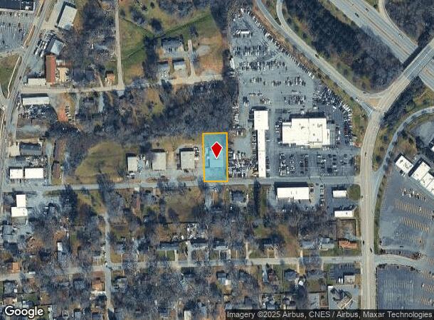
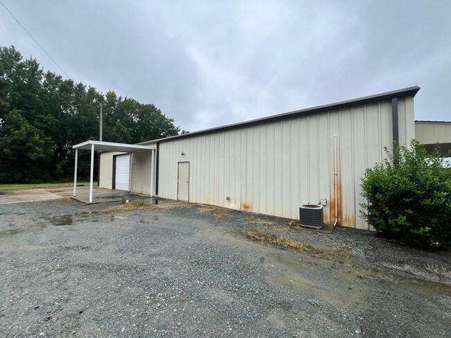
Property Record
202 Pedro St, Monroe, NC 28110

Current Lease Availabilities
NEARBY LISTINGS FOR SALE OR LEASE
Property Detail
202 Pedro St
09-226-032-C
Cyclone Auction
Publicstorage
202 PEDRO ST
X
Union
3710543500J
North Carolina
2025
0.51 AC
2025
Union County
020401
Charlotte
4,500 SF
Charlotte-Concord-Gastonia, NC-SC
DEMOGRAPHICS near 202 Pedro St
1 Mile
3 Mile
5 Mile
2024 Total Population
5,612
30,045
48,222
2029 Population
6,388
33,837
54,343
Pop Growth 2024-2029
+ 13.83%
+ 12.62%
+ 12.69%
Average Age
35
38
39
2024 Total Households
1,882
10,670
17,147
HH Growth 2024-2029
+ 14.03%
+ 12.80%
+ 12.87%
Median Household Inc
$49,301
$56,645
$66,076
Avg Household Size
2.80
2.70
2.70
2024 Avg HH Vehicles
2.00
2.00
2.00
Median Home Value
$151,388
$234,557
$259,451
Median Year Built
1986
1986
1991
Nearby Places
- Restaurants
- Banks
- Shops
- Fitness
- Groceries
PUBLIC TRANSPORTATION
AIRPORT
Charlotte/Douglas International
DRIVE
WALK
Distance
Charlotte/Douglas International
50 min
32.0 mi
Concord-Padgett Regional
DRIVE
WALK
Distance
Concord-Padgett Regional
46 min
34.5 mi
Nearby Properties
Address
Land Use
TOTAL SIZE
Lot Size
Zoning
Address
Land Use
TOTAL SIZE
Lot Size
Zoning
148,145 SF
26.68 AC
G-I MONROE
Address
Land Use
TOTAL SIZE
Lot Size
Zoning
78.48 AC
Address
Land Use
TOTAL SIZE
Lot Size
Zoning
30,708 SF
29.10 AC
R-MF MONRO
Address
Land Use
TOTAL SIZE
Lot Size
Zoning
134,187 SF
32.44 AC
R-10 MONRO
Address
Land Use
TOTAL SIZE
Lot Size
Zoning
18,208 SF
12.09 AC
R-MF MONRO
Address
Land Use
TOTAL SIZE
Lot Size
Zoning
99,235 SF
1.92 AC
CBD MONROE
Address
Land Use
TOTAL SIZE
Lot Size
Zoning
57,664 SF
45.15 AC
R-20 MONRO
Address
Land Use
TOTAL SIZE
Lot Size
Zoning
81,504 SF
30.21 AC
CD MONROE
Address
Land Use
TOTAL SIZE
Lot Size
Zoning
82.26 AC
G-I MONROE
Address
Land Use
TOTAL SIZE
Lot Size
Zoning
71,831 SF
67.94 AC
CD MONROE
Address
Land Use
TOTAL SIZE
Lot Size
Zoning
219,625 SF
36.12 AC
GB MONROE
Address
Land Use
TOTAL SIZE
Lot Size
Zoning
79,493 SF
18.97 AC
CD MONROE
Address
Land Use
TOTAL SIZE
Lot Size
Zoning
62,865 SF
4.87 AC
CD MONROE
Address
Land Use
TOTAL SIZE
Lot Size
Zoning
7,104 SF
11.99 AC
R-MF MONRO
Address
Land Use
TOTAL SIZE
Lot Size
Zoning
54,712 SF
10.01 AC
GB MONROE
Address
Land Use
TOTAL SIZE
Lot Size
Zoning
123,296 SF
9.70 AC
CD MONROE
Address
Land Use
TOTAL SIZE
Lot Size
Zoning
5.89 AC
G-I MONROE
Address
Land Use
TOTAL SIZE
Lot Size
Zoning
4,608 SF
5.08 AC
OT MONROE
Address
Land Use
TOTAL SIZE
Lot Size
Zoning
40,291 SF
3.59 AC
CD MONROE
Address
Land Use
TOTAL SIZE
Lot Size
Zoning
1,920 SF
9.99 AC
R-MF MONRO
Address
Land Use
TOTAL SIZE
Lot Size
Zoning
104,837 SF
29.15 AC
CD MONROE
Address
Land Use
TOTAL SIZE
Lot Size
Zoning
14.77 AC
Address
Land Use
TOTAL SIZE
Lot Size
Zoning
6,440 SF
2.23 AC
GB MONROE
Address
Land Use
TOTAL SIZE
Lot Size
Zoning
101,035 SF
26.11 AC
G-I MONROE
Address
Land Use
TOTAL SIZE
Lot Size
Zoning
9,072 SF
15.23 AC
R-MF MONRO
Address
Land Use
TOTAL SIZE
Lot Size
Zoning
3,276 SF
6.20 AC
R-MF MONRO
Address
Land Use
TOTAL SIZE
Lot Size
Zoning
63,813 SF
1.95 AC
GB MONROE
Address
Land Use
TOTAL SIZE
Lot Size
Zoning
121,790 SF
52.36 AC
G-I MONROE
Address
Land Use
TOTAL SIZE
Lot Size
Zoning
9.57 AC
Address
Land Use
TOTAL SIZE
Lot Size
Zoning
41,820 SF
6.23 AC
G-I MONROE
The World's #1 Commercial Real Estate Marketplace
Connect with us
© 2025 CoStar Group
The information above has been obtained from sources believed reliable. While we do not doubt its accuracy we have not verified it and make no guarantee, warranty or representation about it. It is your responsibility to independently confirm its accuracy and completeness. Any projections, opinions, assumptions, or estimates used are for example only and do not represent the current or future performance of the property. The value of this transaction to you depends on tax and other factors which should be evaluated by your tax, financial, and legal advisors. You and your advisors should conduct a careful, independent investigation of the property to determine to your satisfaction the suitability of the property for your needs.