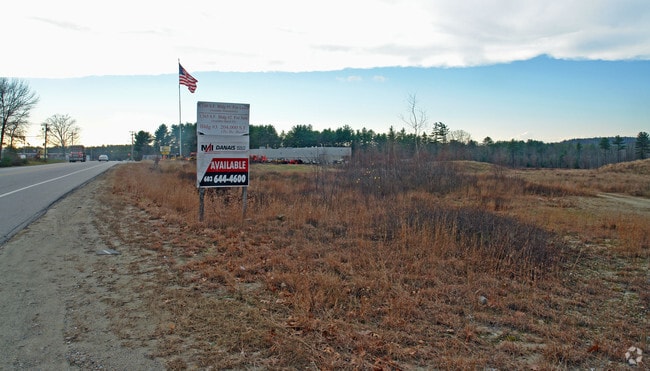
Property Record
200 Plaistow Rd, Plaistow, NH 03865
NEARBY LISTINGS FOR SALE OR LEASE
Property Detail
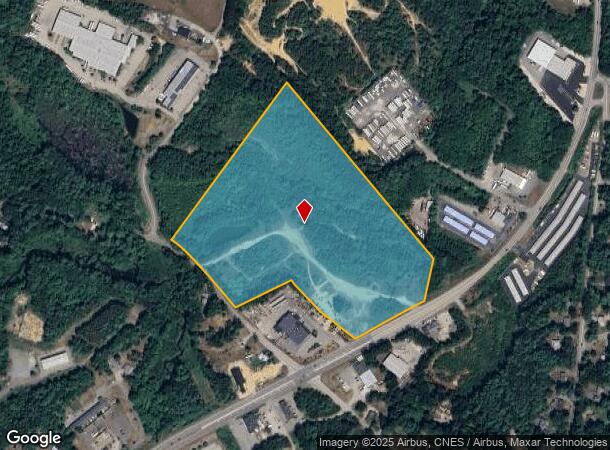
200 Plaistow Rd
PLSW-000044-000009
Rockingham
Commercialacreage
New Hampshire
X
000
25009C0080F
25 AC
2024
Rockingham
2024
Boston
101102
Boston-Cambridge-Newton, MA-NH
DEMOGRAPHICS near 200 Plaistow Rd
1 Mile
3 Mile
5 Mile
2024 Total Population
2,150
15,759
51,430
2029 Population
2,228
16,210
52,233
Pop Growth 2024-2029
+ 3.63%
+ 2.86%
+ 1.56%
Average Age
42
44
43
2024 Total Households
848
6,235
19,850
HH Growth 2024-2029
+ 3.54%
+ 2.76%
+ 1.47%
Median Household Inc
$89,189
$110,630
$109,218
Avg Household Size
2.50
2.50
2.50
2024 Avg HH Vehicles
2.00
2.00
2.00
Median Home Value
$374,680
$396,237
$408,551
Median Year Built
1977
1979
1980
Nearby Places
Map Layers
Map Styles
 Street
 Aerial
- Restaurants
- Banks
- Shops
- Fitness
- Groceries
PUBLIC TRANSPORTATION
COMMUTER RAIL
Haverhill (Haverhill Line - Massachusetts Bay Transportation Authority Commuter Rail (Purple Line))
DRIVE
WALK
Distance
Haverhill (Haverhill Line - Massachusetts Bay Transportation Authority Commuter Rail (Purple Line))
13 min
6.9 mi
Bradford (Haverhill Line - Massachusetts Bay Transportation Authority Commuter Rail (Purple Line))
DRIVE
WALK
Distance
Bradford (Haverhill Line - Massachusetts Bay Transportation Authority Commuter Rail (Purple Line))
14 min
7.4 mi
AIRPORT
Manchester Boston Regional
DRIVE
WALK
Distance
Manchester Boston Regional
52 min
30.0 mi
Portsmouth International at Pease
DRIVE
WALK
Distance
Portsmouth International at Pease
48 min
34.2 mi
Freight Ports
Port of Boston
DRIVE
WALK
Distance
Port of Boston
60 min
42.4 mi
Nearby Properties
Address
Land Use
TOTAL SIZE
Lot Size
Zoning
Address
Land Use
TOTAL SIZE
Lot Size
Zoning
8.79 AC
RRAQ R
Address
Land Use
TOTAL SIZE
Lot Size
Zoning
169,340 SF
14.95 AC
C-1
Address
Land Use
TOTAL SIZE
Lot Size
Zoning
257,286 SF
90 AC
LDR
Address
Land Use
TOTAL SIZE
Lot Size
Zoning
125,627 SF
46.02 AC
C-1
Address
Land Use
TOTAL SIZE
Lot Size
Zoning
35,633 SF
19.15 AC
C-1
Address
Land Use
TOTAL SIZE
Lot Size
Zoning
2,400 SF
4 AC
MDR
Address
Land Use
TOTAL SIZE
Lot Size
Zoning
102,352 SF
19.50 AC
Address
Land Use
TOTAL SIZE
Lot Size
Zoning
5,553 SF
44.71 AC
A-RES
Address
Land Use
TOTAL SIZE
Lot Size
Zoning
115,088 SF
27.42 AC
Address
Land Use
TOTAL SIZE
Lot Size
Zoning
2.09 AC
LDR
Address
Land Use
TOTAL SIZE
Lot Size
Zoning
127,248 SF
18.69 AC
C-1
Address
Land Use
TOTAL SIZE
Lot Size
Zoning
39,670 SF
26.55 AC
RES-A
Address
Land Use
TOTAL SIZE
Lot Size
Zoning
55,960 SF
12.42 AC
I
Address
Land Use
TOTAL SIZE
Lot Size
Zoning
184,193 SF
24.80 AC
I
Address
Land Use
TOTAL SIZE
Lot Size
Zoning
32,074 SF
6.69 AC
C-1
Address
Land Use
TOTAL SIZE
Lot Size
Zoning
67,705 SF
10.93 AC
TC- TO
Address
Land Use
TOTAL SIZE
Lot Size
Zoning
70,433 SF
30.77 AC
VC
Address
Land Use
TOTAL SIZE
Lot Size
Zoning
79,184 SF
9.96 AC
C-3
Address
Land Use
TOTAL SIZE
Lot Size
Zoning
130,422 SF
16.95 AC
LIGHT
Address
Land Use
TOTAL SIZE
Lot Size
Zoning
16,020 SF
6.68 AC
VC
Address
Land Use
TOTAL SIZE
Lot Size
Zoning
19,823 SF
2.60 AC
C-1
Address
Land Use
TOTAL SIZE
Lot Size
Zoning
19,120 SF
14.41 AC
C-1
Address
Land Use
TOTAL SIZE
Lot Size
Zoning
17,856 SF
19.80 AC
C-3
Address
Land Use
TOTAL SIZE
Lot Size
Zoning
48,400 SF
5.75 AC
I
Address
Land Use
TOTAL SIZE
Lot Size
Zoning
27,362 SF
2.51 AC
C-3
Address
Land Use
TOTAL SIZE
Lot Size
Zoning
1,577 SF
122.25 AC
RRAQ R
Address
Land Use
TOTAL SIZE
Lot Size
Zoning
14,807 SF
1.18 AC
C-1
Address
Land Use
TOTAL SIZE
Lot Size
Zoning
66,288 SF
50.31 AC
LIGHT
Address
Land Use
TOTAL SIZE
Lot Size
Zoning
18,875 SF
1.87 AC
C-1
Address
Land Use
TOTAL SIZE
Lot Size
Zoning
4,025 SF
45.06 AC
RES-A
The World's #1 Commercial Real Estate Marketplace
Connect with us
© 2025 CoStar Group
The information above has been obtained from sources believed reliable. While we do not doubt its accuracy we have not verified it and make no guarantee, warranty or representation about it. It is your responsibility to independently confirm its accuracy and completeness. Any projections, opinions, assumptions, or estimates used are for example only and do not represent the current or future performance of the property. The value of this transaction to you depends on tax and other factors which should be evaluated by your tax, financial, and legal advisors. You and your advisors should conduct a careful, independent investigation of the property to determine to your satisfaction the suitability of the property for your needs.