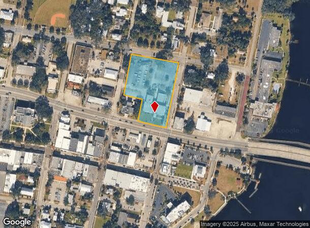
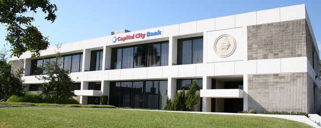
Property Record
200 Reid St, Palatka, FL 32177

NEARBY LISTINGS FOR SALE OR LEASE
Property Detail
200 Reid St
Palatka, FL
Palatka
42-10-27-6850-0100-0000
DICKS MAP OF PALATKA MB2 P46, BLK 10 LOTS 1 2 3 E 30FT OF, LOT 4 LOTS 5 6 7 8 9 10 & 11
Publicschool
Putnam
X
Florida
12107C0194C
4
0
2.94 AC
2025
Florida Central North Area
950800
Other Market Areas
13,060 SF
DEMOGRAPHICS near 200 Reid St
1 Mile
3 Mile
5 Mile
2024 Total Population
2,195
14,860
24,806
2029 Population
2,283
15,320
25,624
Pop Growth 2024-2029
+ 4.01%
+ 3.10%
+ 3.30%
Average Age
41
41
42
2024 Total Households
908
5,861
9,902
HH Growth 2024-2029
+ 4.19%
+ 2.99%
+ 3.23%
Median Household Inc
$25,688
$29,478
$32,703
Avg Household Size
2.40
2.40
2.40
2024 Avg HH Vehicles
1.00
2.00
2.00
Median Home Value
$85,858
$126,028
$140,029
Median Year Built
1949
1970
1976
Nearby Places
Map Layers
Map Styles
 Street
 Aerial
- Restaurants
- Banks
- Shops
- Fitness
- Groceries
PUBLIC TRANSPORTATION
COMMUTER RAIL
Palatka Amtrak (Silver Meteor - Amtrak, Silver Star - Amtrak)
DRIVE
WALK
Distance
Palatka Amtrak (Silver Meteor - Amtrak, Silver Star - Amtrak)
2 min
14 min
0.7 mi
Freight Ports
Jacksonville Port
DRIVE
WALK
Distance
Jacksonville Port
84 min
64.8 mi
Nearby Properties
Address
Land Use
TOTAL SIZE
Lot Size
Zoning
Address
Land Use
TOTAL SIZE
Lot Size
Zoning
174,699 SF
41.50 AC
Address
Land Use
TOTAL SIZE
Lot Size
Zoning
54,720 SF
29.19 AC
Address
Land Use
TOTAL SIZE
Lot Size
Zoning
106,319 SF
28.86 AC
Address
Land Use
TOTAL SIZE
Lot Size
Zoning
97,240 SF
12.72 AC
Address
Land Use
TOTAL SIZE
Lot Size
Zoning
33,616 SF
38.79 AC
Address
Land Use
TOTAL SIZE
Lot Size
Zoning
43,844 SF
31.63 AC
Address
Land Use
TOTAL SIZE
Lot Size
Zoning
75,330 SF
6.63 AC
Address
Land Use
TOTAL SIZE
Lot Size
Zoning
1,120 SF
12.44 AC
Address
Land Use
TOTAL SIZE
Lot Size
Zoning
45,991 SF
1.69 AC
Address
Land Use
TOTAL SIZE
Lot Size
Zoning
47,010 SF
9.43 AC
Address
Land Use
TOTAL SIZE
Lot Size
Zoning
39,660 SF
12.04 AC
Address
Land Use
TOTAL SIZE
Lot Size
Zoning
15.93 AC
Address
Land Use
TOTAL SIZE
Lot Size
Zoning
14,040 SF
14.25 AC
Address
Land Use
TOTAL SIZE
Lot Size
Zoning
10,503 SF
1.98 AC
Address
Land Use
TOTAL SIZE
Lot Size
Zoning
13,825 SF
4.13 AC
Address
Land Use
TOTAL SIZE
Lot Size
Zoning
2,444 SF
29.51 AC
Address
Land Use
TOTAL SIZE
Lot Size
Zoning
64,863 SF
18.29 AC
Address
Land Use
TOTAL SIZE
Lot Size
Zoning
75,592 SF
7.87 AC
Address
Land Use
TOTAL SIZE
Lot Size
Zoning
18,895 SF
11.20 AC
Address
Land Use
TOTAL SIZE
Lot Size
Zoning
6,892 SF
29 AC
Address
Land Use
TOTAL SIZE
Lot Size
Zoning
6,120 SF
6.32 AC
Address
Land Use
TOTAL SIZE
Lot Size
Zoning
67,425 SF
17.47 AC
Address
Land Use
TOTAL SIZE
Lot Size
Zoning
9,250 SF
96.36 AC
Address
Land Use
TOTAL SIZE
Lot Size
Zoning
4,176 SF
6.77 AC
Address
Land Use
TOTAL SIZE
Lot Size
Zoning
19,344 SF
4.74 AC
Address
Land Use
TOTAL SIZE
Lot Size
Zoning
57,141 SF
37.09 AC
Address
Land Use
TOTAL SIZE
Lot Size
Zoning
13,054 SF
2.25 AC
Address
Land Use
TOTAL SIZE
Lot Size
Zoning
32,222 SF
3.13 AC
Address
Land Use
TOTAL SIZE
Lot Size
Zoning
9,776 SF
3.87 AC
Address
Land Use
TOTAL SIZE
Lot Size
Zoning
10,015 SF
2.02 AC
The World's #1 Commercial Real Estate Marketplace
Connect with us
© 2026 CoStar Group
The information above has been obtained from sources believed reliable. While we do not doubt its accuracy we have not verified it and make no guarantee, warranty or representation about it. It is your responsibility to independently confirm its accuracy and completeness. Any projections, opinions, assumptions, or estimates used are for example only and do not represent the current or future performance of the property. The value of this transaction to you depends on tax and other factors which should be evaluated by your tax, financial, and legal advisors. You and your advisors should conduct a careful, independent investigation of the property to determine to your satisfaction the suitability of the property for your needs.