Property Record
319 Rowan St, Salem, VA 24153


Current Lease Availabilities
NEARBY LISTINGS FOR SALE OR LEASE
Property Detail
319 Rowan St
Roanoke, VA
900
232-1-1
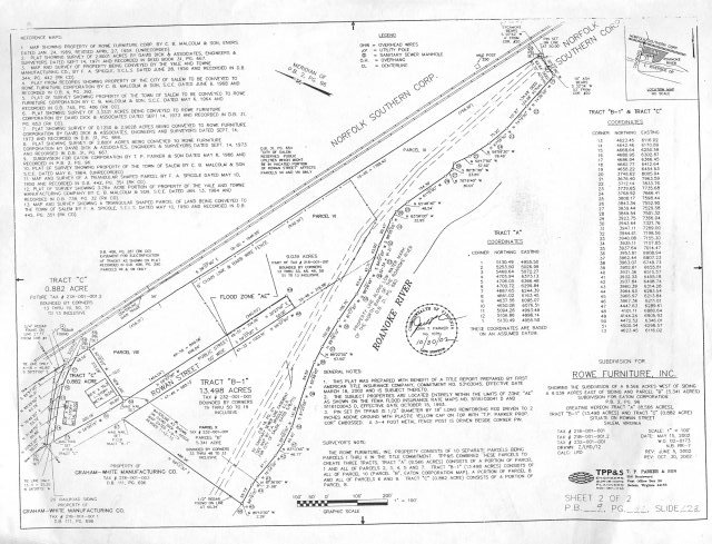
TRACT B-1 13.498 AC ROWE FURNITURE INC SUBD
Industrialacreage
Salem City
AE
Virginia
51161C0143G
13.50 AC
2025
Southwest Roanoke
2025
Roanoke
010300
DEMOGRAPHICS near 319 Rowan St
1 mile
3 mile
5 mile
2024 Total Population
5,980
44,602
105,653
2029 Population
6,162
44,920
105,292
Pop Growth 2024-2029
+ 3.04%
+ 0.71%
(0.34%)
Average Age
41
43
42
2024 Total Households
2,611
18,378
44,553
HH Growth 2024-2029
+ 3.26%
+ 0.77%
(0.38%)
Median Household Inc
$63,123
$66,138
$61,106
Avg Household Size
2.20
2.30
2.30
2024 Avg HH Vehicles
2.00
2.00
2.00
Median Home Value
$202,075
$237,673
$224,298
Median Year Built
1968
1969
1968
Nearby Places
Map Layers
Map Styles
 Street
 Aerial
Transit
 Traffic
 Biking
Places
Listings with unknown addresses are not visible on the map
- Restaurants
- Banks
- Shops
- Fitness
- Groceries
PUBLIC TRANSPORTATION
COMMUTER RAIL
Drive
Walk
Distance
17 min
7.7 mi
AIRPORT
Roanoke/Blacksburg Regional (Woodrum Field)
Drive
Walk
Distance
Roanoke/Blacksburg Regional (Woodrum Field)
20 min
8.4 mi
Nearby Properties
Address
Land Use
TOTAL SIZE
Lot Size
Zoning
Address
Land Use
TOTAL SIZE
Lot Size
Zoning
160 AC
RSF
Address
Land Use
TOTAL SIZE
Lot Size
Zoning
81,148 SF
52.04 AC
CUDRSF
Address
Land Use
TOTAL SIZE
Lot Size
Zoning
288,464 SF
40.14 AC
RSF
Address
Land Use
TOTAL SIZE
Lot Size
Zoning
421,634 SF
15.99 AC
HBD
Address
Land Use
TOTAL SIZE
Lot Size
Zoning
177,095 SF
18.55 AC
RMF
Address
Land Use
TOTAL SIZE
Lot Size
Zoning
69,831 SF
73.54 AC
HBD
Address
Land Use
TOTAL SIZE
Lot Size
Zoning
155,000 SF
3.78 AC
CUD
Address
Land Use
TOTAL SIZE
Lot Size
Zoning
181,455 SF
6.24 AC
RMF
Address
Land Use
TOTAL SIZE
Lot Size
Zoning
134,471 SF
16.39 AC
RMF
Address
Land Use
TOTAL SIZE
Lot Size
Zoning
95,349 SF
10.25 AC
RSF
Address
Land Use
TOTAL SIZE
Lot Size
Zoning
76,280 SF
9.51 AC
CUD
Address
Land Use
TOTAL SIZE
Lot Size
Zoning
138,887 SF
13.03 AC
HBD
Address
Land Use
TOTAL SIZE
Lot Size
Zoning
120,584 SF
9.41 AC
HM
Address
Land Use
TOTAL SIZE
Lot Size
Zoning
331,365 SF
61.27 AC
I-2
Address
Land Use
TOTAL SIZE
Lot Size
Zoning
565,151 SF
56.04 AC
HM
Address
Land Use
TOTAL SIZE
Lot Size
Zoning
122,462 SF
40.92 AC
INPUD
Address
Land Use
TOTAL SIZE
Lot Size
Zoning
28,221 SF
20.18 AC
RMF
Address
Land Use
TOTAL SIZE
Lot Size
Zoning
161,757 SF
13.22 AC
HBD
Address
Land Use
TOTAL SIZE
Lot Size
Zoning
10,713 SF
12.44 AC
R3
Address
Land Use
TOTAL SIZE
Lot Size
Zoning
159,727 SF
13.32 AC
C1
Address
Land Use
TOTAL SIZE
Lot Size
Zoning
442,530 SF
40.32 AC
HM
Address
Land Use
TOTAL SIZE
Lot Size
Zoning
47,451 SF
1.58 AC
RB
Address
Land Use
TOTAL SIZE
Lot Size
Zoning
32,286 SF
3.62 AC
RMF
Address
Land Use
TOTAL SIZE
Lot Size
Zoning
314,182 SF
22.87 AC
HM
Address
Land Use
TOTAL SIZE
Lot Size
Zoning
100 SF
60.09 AC
RSF
Address
Land Use
TOTAL SIZE
Lot Size
Zoning
87,526 SF
4.12 AC
RMF
Address
Land Use
TOTAL SIZE
Lot Size
Zoning
10,944 SF
18.21 AC
RMF
Address
Land Use
TOTAL SIZE
Lot Size
Zoning
11,613 SF
11.27 AC
RMF
Address
Land Use
TOTAL SIZE
Lot Size
Zoning
74,712 SF
2.13 AC
DBD
Address
Land Use
TOTAL SIZE
Lot Size
Zoning
100,915 SF
13.80 AC
HM
The World's #1 Commercial Real Estate Marketplace
Connect with us
© 2026 CoStar Group
The information above has been obtained from sources believed reliable. While we do not doubt its accuracy we have not verified it and make no guarantee, warranty or representation about it. It is your responsibility to independently confirm its accuracy and completeness. Any projections, opinions, assumptions, or estimates used are for example only and do not represent the current or future performance of the property. The value of this transaction to you depends on tax and other factors which should be evaluated by your tax, financial, and legal advisors. You and your advisors should conduct a careful, independent investigation of the property to determine to your satisfaction the suitability of the property for your needs.