Property Record
200 S 56Th St, Chandler, AZ 85226

Save to a Folder
{{folder.Name}}
{{folder.ListingIds.length}} Properties
{{folder.ListingIds.length}} Property
Create a New Folder
Property Detail
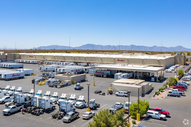
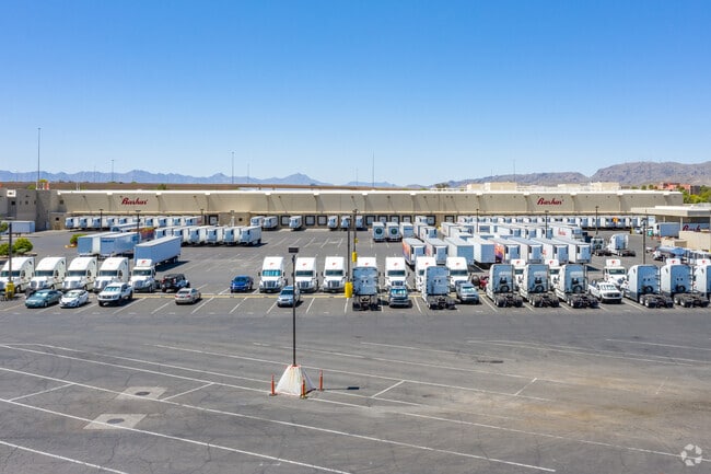
200 S 56Th St
301-85-367
PRT S2 NE4 SEC 32 DAF BEG AT E4 COR TH W 1400.85F TH N ALG MID SEC LN 1318.76F TO N LN SD S2 TH E 1389.48F TH S 1312.57F TO POB EX S & W 30F & EX E 55F RD
Truckterminal
Maricopa
I-1
Arizona
AO River or stream flood hazard areas, and areas with a 1% or greater chance of shallow flooding each year. These areas have a 26% chance of flooding over the life of a 30-year mortgage.
38.66 AC
2025
Chandler
2025
Phoenix
980400
Phoenix-Mesa-Chandler, AZ
713,461 SF
NEARBY LISTINGS FOR SALE OR LEASE
DEMOGRAPHICS near 200 S 56Th St
1 mile
3 mile
5 mile
2025 Total Population
3,487
69,706
153,321
2030 Population
3,613
71,553
157,410
Pop Growth 2025-2030
+ 3.61%
+ 2.65%
+ 2.67%
Average Age
37
40
40
2025 Total Households
1,648
28,054
61,844
HH Growth 2025-2030
+ 3.58%
+ 2.71%
+ 2.75%
Median Household Inc
$80,357
$108,942
$108,327
Avg Household Size
2.10
2.40
2.40
2025 Avg HH Vehicles
1.00
2.00
2.00
Median Home Value
$467,434
$525,434
$535,808
Median Year Built
2003
1992
1991
Nearby Places
Map Layers
Map Styles
 Street
 Aerial
Layers
 Traffic
 Biking
Places
Listings with unknown addresses are not visible on the map
- Restaurants
- Banks
- Shops
- Fitness
- Groceries
PUBLIC TRANSPORTATION
AIRPORT
Phoenix Sky Harbor International
Drive
Walk
Distance
Phoenix Sky Harbor International
20 min
12.6 mi
Phoenix-Mesa Gateway
Drive
Walk
Distance
Phoenix-Mesa Gateway
29 min
19.0 mi
Nearby Properties
Address
Land Use
TOTAL SIZE
Lot Size
Zoning
Address
Land Use
TOTAL SIZE
Lot Size
Zoning
47,945 SF
8.35 AC
C-C
Address
Land Use
TOTAL SIZE
Lot Size
Zoning
1,149,733 SF
70.56 AC
PAD
Address
Land Use
TOTAL SIZE
Lot Size
Zoning
14.98 AC
I-1
Address
Land Use
TOTAL SIZE
Lot Size
Zoning
656,241 SF
29.09 AC
PAD
Address
Land Use
TOTAL SIZE
Lot Size
Zoning
1,085,359 SF
74.95 AC
PAD
Address
Land Use
TOTAL SIZE
Lot Size
Zoning
390,410 SF
47.65 AC
R-35
Address
Land Use
TOTAL SIZE
Lot Size
Zoning
400,000 SF
51.42 AC
PAD
Address
Land Use
TOTAL SIZE
Lot Size
Zoning
442,642 SF
35.15 AC
GID
Address
Land Use
TOTAL SIZE
Lot Size
Zoning
393,258 SF
49.79 AC
AG
Address
Land Use
TOTAL SIZE
Lot Size
Zoning
412,062 SF
21.84 AC
C-C
Address
Land Use
TOTAL SIZE
Lot Size
Zoning
283,782 SF
25.29 AC
I-1
Address
Land Use
TOTAL SIZE
Lot Size
Zoning
409,148 SF
29.15 AC
I-1
Address
Land Use
TOTAL SIZE
Lot Size
Zoning
230,853 SF
23.41 AC
C-R
Address
Land Use
TOTAL SIZE
Lot Size
Zoning
244,900 SF
38.47 AC
PF
Address
Land Use
TOTAL SIZE
Lot Size
Zoning
300,965 SF
13.37 AC
PAD
Address
Land Use
TOTAL SIZE
Lot Size
Zoning
229,469 SF
23.78 AC
PAD
Address
Land Use
TOTAL SIZE
Lot Size
Zoning
240,814 SF
22.70 AC
C2
Address
Land Use
TOTAL SIZE
Lot Size
Zoning
422,759 SF
22.23 AC
M-H
Address
Land Use
TOTAL SIZE
Lot Size
Zoning
480,044 SF
20.47 AC
R-3A
Address
Land Use
TOTAL SIZE
Lot Size
Zoning
13,636 SF
32.62 AC
R-35
Address
Land Use
TOTAL SIZE
Lot Size
Zoning
306,300 SF
16.54 AC
PAD
Address
Land Use
TOTAL SIZE
Lot Size
Zoning
215,895 SF
17.49 AC
C-C
Address
Land Use
TOTAL SIZE
Lot Size
Zoning
177,459 SF
6.87 AC
PAD
Address
Land Use
TOTAL SIZE
Lot Size
Zoning
175,654 SF
12.13 AC
PAD
Address
Land Use
TOTAL SIZE
Lot Size
Zoning
225,117 SF
4.85 AC
PAD
Address
Land Use
TOTAL SIZE
Lot Size
Zoning
298,447 SF
16.30 AC
M-H
Address
Land Use
TOTAL SIZE
Lot Size
Zoning
108,932 SF
12 AC
I-1
Address
Land Use
TOTAL SIZE
Lot Size
Zoning
288,375 SF
14.47 AC
M-H
Address
Land Use
TOTAL SIZE
Lot Size
Zoning
131,171 SF
16.80 AC
PAD
The World's #1 Commercial Real Estate Marketplace
Connect with us
© 2026 CoStar Group
The information above has been obtained from sources believed reliable. While we do not doubt its accuracy we have not verified it and make no guarantee, warranty or representation about it. It is your responsibility to independently confirm its accuracy and completeness. Any projections, opinions, assumptions, or estimates used are for example only and do not represent the current or future performance of the property. The value of this transaction to you depends on tax and other factors which should be evaluated by your tax, financial, and legal advisors. You and your advisors should conduct a careful, independent investigation of the property to determine to your satisfaction the suitability of the property for your needs.