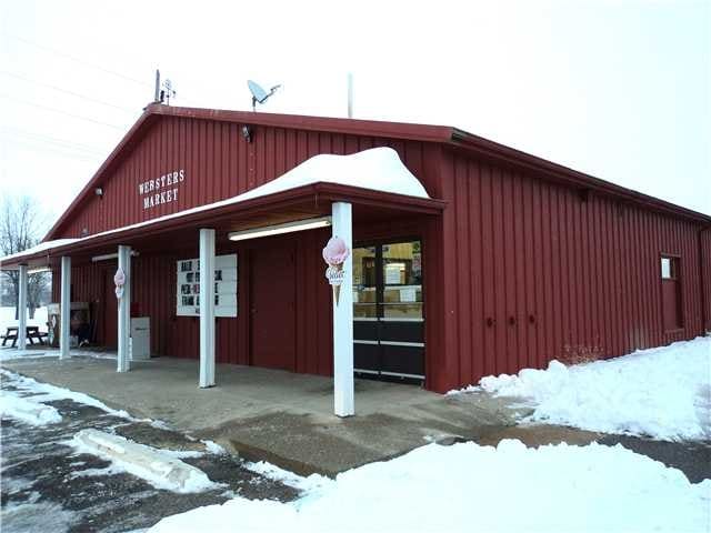
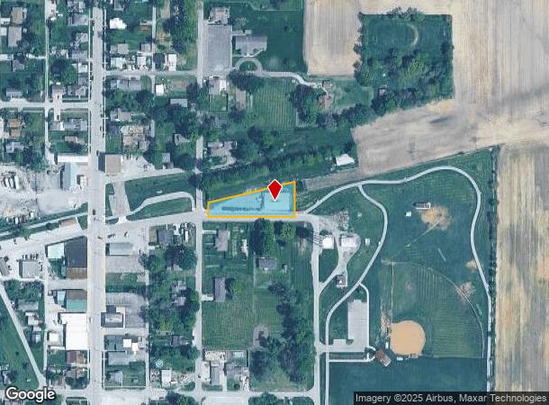
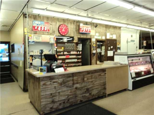
Property Record
200 S Railroad St, Shirley, IN 47384
NEARBY LISTINGS FOR SALE OR LEASE
-
-
View all Shirley listings for sale on LoopNet.com
Property Detail
200 S Railroad St
New Castle, IN
Woodlawn Addition
33-10-25-310-328.000-010
WOODLAWN ADD LOTS 13, 14 & 15 BLK 3 & VAC ALLEY
Supermarket
Henry
X
Indiana
18065C0115D
13-15
2024
0.53 AC
2024
Henry County
975700
Indianapolis
4,320 SF
DEMOGRAPHICS near 200 S Railroad St
1 Mile
3 Mile
5 Mile
2024 Total Population
1,025
2,311
4,158
2029 Population
1,078
2,403
4,305
Pop Growth 2024-2029
+ 5.17%
+ 3.98%
+ 3.54%
Average Age
41
41
42
2024 Total Households
410
930
1,633
HH Growth 2024-2029
+ 5.61%
+ 4.30%
+ 3.80%
Median Household Inc
$75,379
$69,972
$68,837
Avg Household Size
2.50
2.50
2.50
2024 Avg HH Vehicles
2.00
2.00
2.00
Median Home Value
$114,000
$131,376
$163,132
Median Year Built
1953
1954
1958
Nearby Places
Map Layers
Map Styles
 Street
 Aerial
- Restaurants
- Banks
- Shops
- Fitness
- Groceries
Nearby Properties
Address
Land Use
TOTAL SIZE
Lot Size
Zoning
Address
Land Use
TOTAL SIZE
Lot Size
Zoning
38,649 SF
9.40 AC
Address
Land Use
TOTAL SIZE
Lot Size
Zoning
26,349 SF
5.50 AC
Address
Land Use
TOTAL SIZE
Lot Size
Zoning
7,920 SF
2.38 AC
Address
Land Use
TOTAL SIZE
Lot Size
Zoning
4,276 SF
1.22 AC
Address
Land Use
TOTAL SIZE
Lot Size
Zoning
213.18 AC
Address
Land Use
TOTAL SIZE
Lot Size
Zoning
165.85 AC
Address
Land Use
TOTAL SIZE
Lot Size
Zoning
158.20 AC
Address
Land Use
TOTAL SIZE
Lot Size
Zoning
19,405 SF
1.03 AC
Address
Land Use
TOTAL SIZE
Lot Size
Zoning
158.32 AC
Address
Land Use
TOTAL SIZE
Lot Size
Zoning
120.62 AC
Address
Land Use
TOTAL SIZE
Lot Size
Zoning
139.51 AC
Address
Land Use
TOTAL SIZE
Lot Size
Zoning
156.47 AC
Address
Land Use
TOTAL SIZE
Lot Size
Zoning
68.81 AC
Address
Land Use
TOTAL SIZE
Lot Size
Zoning
131.24 AC
Address
Land Use
TOTAL SIZE
Lot Size
Zoning
16.53 AC
Address
Land Use
TOTAL SIZE
Lot Size
Zoning
82.86 AC
Address
Land Use
TOTAL SIZE
Lot Size
Zoning
105.88 AC
Address
Land Use
TOTAL SIZE
Lot Size
Zoning
72.46 AC
Address
Land Use
TOTAL SIZE
Lot Size
Zoning
7,000 SF
12 AC
Address
Land Use
TOTAL SIZE
Lot Size
Zoning
114.50 AC
Address
Land Use
TOTAL SIZE
Lot Size
Zoning
10,584 SF
0.42 AC
Address
Land Use
TOTAL SIZE
Lot Size
Zoning
104.20 AC
Address
Land Use
TOTAL SIZE
Lot Size
Zoning
33.98 AC
Address
Land Use
TOTAL SIZE
Lot Size
Zoning
81.11 AC
Address
Land Use
TOTAL SIZE
Lot Size
Zoning
9,040 SF
5 AC
Address
Land Use
TOTAL SIZE
Lot Size
Zoning
78.55 AC
Address
Land Use
TOTAL SIZE
Lot Size
Zoning
Address
Land Use
TOTAL SIZE
Lot Size
Zoning
9,035 SF
0.56 AC
Address
Land Use
TOTAL SIZE
Lot Size
Zoning
Address
Land Use
TOTAL SIZE
Lot Size
Zoning
72.05 AC
The World's #1 Commercial Real Estate Marketplace
Connect with us
© 2025 CoStar Group
The information above has been obtained from sources believed reliable. While we do not doubt its accuracy we have not verified it and make no guarantee, warranty or representation about it. It is your responsibility to independently confirm its accuracy and completeness. Any projections, opinions, assumptions, or estimates used are for example only and do not represent the current or future performance of the property. The value of this transaction to you depends on tax and other factors which should be evaluated by your tax, financial, and legal advisors. You and your advisors should conduct a careful, independent investigation of the property to determine to your satisfaction the suitability of the property for your needs.