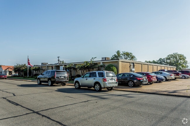
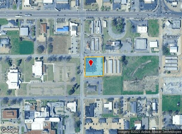
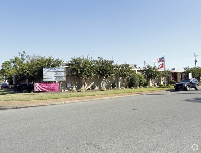
Property Record
200 S Rhodes St, West Memphis, AR 72301
NEARBY LISTINGS FOR SALE OR LEASE
-
-
View all West Memphis listings for sale on LoopNet.com
Property Detail
200 S Rhodes St
Memphis, TN-MS-AR
Eugene Woods
392-040000-000
---
Medicalbuilding
Crittenden
X
Arkansas
05035C0345E
4
2025
0.09 AC
2025
Crittenden County
030302
Memphis
14,716 SF
DEMOGRAPHICS near 200 S Rhodes St
1 Mile
3 Mile
5 Mile
2024 Total Population
7,496
25,114
36,029
2029 Population
7,257
24,532
35,007
Pop Growth 2024-2029
(3.19%)
(2.32%)
(2.84%)
Average Age
39
38
38
2024 Total Households
3,108
10,012
14,128
HH Growth 2024-2029
(3.25%)
(2.37%)
(2.85%)
Median Household Inc
$29,738
$36,255
$44,012
Avg Household Size
2.30
2.40
2.50
2024 Avg HH Vehicles
1.00
1.00
2.00
Median Home Value
$102,211
$109,568
$138,841
Median Year Built
1978
1976
1982
Nearby Places
Map Layers
Map Styles
 Street
 Aerial
- Restaurants
- Banks
- Shops
- Fitness
- Groceries
PUBLIC TRANSPORTATION
COMMUTER RAIL
Central Station (Riverfront Loop - Memphis Area Transit Authority Trolley (MataTrolley))
DRIVE
WALK
Distance
Central Station (Riverfront Loop - Memphis Area Transit Authority Trolley (MataTrolley))
13 min
8.3 mi
AIRPORT
Memphis International
DRIVE
WALK
Distance
Memphis International
30 min
17.7 mi
Nearby Properties
Address
Land Use
TOTAL SIZE
Lot Size
Zoning
Address
Land Use
TOTAL SIZE
Lot Size
Zoning
148,005 SF
134.67 AC
Address
Land Use
TOTAL SIZE
Lot Size
Zoning
847,384 SF
77.14 AC
Address
Land Use
TOTAL SIZE
Lot Size
Zoning
69,600 SF
38.09 AC
Address
Land Use
TOTAL SIZE
Lot Size
Zoning
46,927 SF
7.52 AC
Address
Land Use
TOTAL SIZE
Lot Size
Zoning
665,000 SF
46.40 AC
Address
Land Use
TOTAL SIZE
Lot Size
Zoning
209,064 SF
26.97 AC
Address
Land Use
TOTAL SIZE
Lot Size
Zoning
79,208 SF
3.98 AC
Address
Land Use
TOTAL SIZE
Lot Size
Zoning
72,051 SF
1.98 AC
Address
Land Use
TOTAL SIZE
Lot Size
Zoning
87,608 SF
10.02 AC
Address
Land Use
TOTAL SIZE
Lot Size
Zoning
28,600 SF
7 AC
Address
Land Use
TOTAL SIZE
Lot Size
Zoning
70,994 SF
3.06 AC
Address
Land Use
TOTAL SIZE
Lot Size
Zoning
7,482 SF
7.17 AC
Address
Land Use
TOTAL SIZE
Lot Size
Zoning
194,110 SF
125.33 AC
Address
Land Use
TOTAL SIZE
Lot Size
Zoning
131,846 SF
27.83 AC
Address
Land Use
TOTAL SIZE
Lot Size
Zoning
328,229 SF
20 AC
Address
Land Use
TOTAL SIZE
Lot Size
Zoning
12,088 SF
98.07 AC
Address
Land Use
TOTAL SIZE
Lot Size
Zoning
46,035 SF
2.31 AC
Address
Land Use
TOTAL SIZE
Lot Size
Zoning
148,342 SF
9.87 AC
Address
Land Use
TOTAL SIZE
Lot Size
Zoning
2,728 SF
10.54 AC
Address
Land Use
TOTAL SIZE
Lot Size
Zoning
43,781 SF
1.65 AC
Address
Land Use
TOTAL SIZE
Lot Size
Zoning
43,570 SF
1.80 AC
Address
Land Use
TOTAL SIZE
Lot Size
Zoning
64,791 SF
3.57 AC
Address
Land Use
TOTAL SIZE
Lot Size
Zoning
23,900 SF
11.23 AC
Address
Land Use
TOTAL SIZE
Lot Size
Zoning
52,902 SF
Address
Land Use
TOTAL SIZE
Lot Size
Zoning
3,456 SF
6.09 AC
Address
Land Use
TOTAL SIZE
Lot Size
Zoning
8,178 SF
6.06 AC
Address
Land Use
TOTAL SIZE
Lot Size
Zoning
8,178 SF
3.99 AC
Address
Land Use
TOTAL SIZE
Lot Size
Zoning
12,000 SF
10.35 AC
Address
Land Use
TOTAL SIZE
Lot Size
Zoning
31,630 SF
9.58 AC
Address
Land Use
TOTAL SIZE
Lot Size
Zoning
13,015 SF
11.60 AC
The World's #1 Commercial Real Estate Marketplace
Connect with us
© 2025 CoStar Group
The information above has been obtained from sources believed reliable. While we do not doubt its accuracy we have not verified it and make no guarantee, warranty or representation about it. It is your responsibility to independently confirm its accuracy and completeness. Any projections, opinions, assumptions, or estimates used are for example only and do not represent the current or future performance of the property. The value of this transaction to you depends on tax and other factors which should be evaluated by your tax, financial, and legal advisors. You and your advisors should conduct a careful, independent investigation of the property to determine to your satisfaction the suitability of the property for your needs.