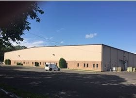
Property Record
200 S Route 73, Hammonton, NJ 08037

NEARBY LISTINGS FOR SALE OR LEASE
Property Detail
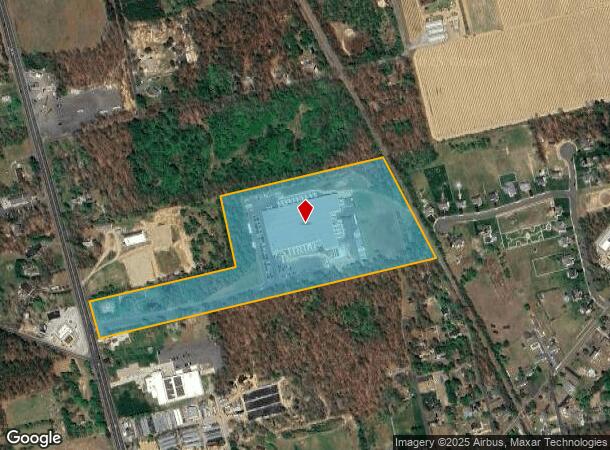
200 S Route 73
36-05806-0000-00006
202 S ROUTE 73 (H), 20% FOR 2000
Commercialnec
Camden
X
New Jersey
34007C0209E
6
2024
21.47 AC
2025
Camden County
609205
Philadelphia
2,264 SF
Philadelphia-Camden-Wilmington, PA-NJ-DE-MD
DEMOGRAPHICS near 200 S Route 73
1 Mile
3 Mile
5 Mile
2024 Total Population
1,293
11,136
36,739
2029 Population
1,277
11,089
37,057
Pop Growth 2024-2029
(1.24%)
(0.42%)
+ 0.87%
Average Age
44
44
42
2024 Total Households
470
3,977
13,466
HH Growth 2024-2029
(1.49%)
(0.45%)
+ 0.88%
Median Household Inc
$80,787
$93,274
$83,956
Avg Household Size
2.70
2.60
2.60
2024 Avg HH Vehicles
3.00
2.00
2.00
Median Home Value
$249,238
$257,776
$244,459
Median Year Built
1958
1976
1978
Nearby Places
Map Layers
Map Styles
 Street
 Aerial
- Restaurants
- Banks
- Shops
- Fitness
- Groceries
PUBLIC TRANSPORTATION
COMMUTER RAIL
Atco (Atlantic City Line - NJ Transit Commuter Rail (NJ Transit))
DRIVE
WALK
Distance
Atco (Atlantic City Line - NJ Transit Commuter Rail (NJ Transit))
11 min
8.1 mi
Hammonton (Atlantic City Line - NJ Transit Commuter Rail (NJ Transit))
DRIVE
WALK
Distance
Hammonton (Atlantic City Line - NJ Transit Commuter Rail (NJ Transit))
14 min
8.9 mi
AIRPORT
Atlantic City International
DRIVE
WALK
Distance
Atlantic City International
57 min
29.8 mi
Philadelphia International
DRIVE
WALK
Distance
Philadelphia International
49 min
33.1 mi
Freight Ports
Broadway Terminal - Pier 5
DRIVE
WALK
Distance
Broadway Terminal - Pier 5
33 min
24.6 mi
SALE & LEASE HISTORY
LISTING DATE
SALE/LEASE

Jul 28, 2017
For Sale
Jan 12, 2018
For Lease
Jan 12, 2018
For Sale
Nearby Properties
Address
Land Use
TOTAL SIZE
Lot Size
Zoning
Address
Land Use
TOTAL SIZE
Lot Size
Zoning
605.38 AC
ANC
Address
Land Use
TOTAL SIZE
Lot Size
Zoning
30.01 AC
PR2
Address
Land Use
TOTAL SIZE
Lot Size
Zoning
11.87 AC
RM
Address
Land Use
TOTAL SIZE
Lot Size
Zoning
26.68 AC
PI2
Address
Land Use
TOTAL SIZE
Lot Size
Zoning
30 AC
PR2
Address
Land Use
TOTAL SIZE
Lot Size
Zoning
4,200 SF
13.22 AC
PC1
Address
Land Use
TOTAL SIZE
Lot Size
Zoning
1,718 SF
68.48 AC
PR2
Address
Land Use
TOTAL SIZE
Lot Size
Zoning
45.89 AC
PR1
Address
Land Use
TOTAL SIZE
Lot Size
Zoning
6.20 AC
Address
Land Use
TOTAL SIZE
Lot Size
Zoning
1.50 AC
PR4
Address
Land Use
TOTAL SIZE
Lot Size
Zoning
720.84 AC
PRC
Address
Land Use
TOTAL SIZE
Lot Size
Zoning
20.41 AC
Address
Land Use
TOTAL SIZE
Lot Size
Zoning
56.37 AC
C
Address
Land Use
TOTAL SIZE
Lot Size
Zoning
109.70 AC
PA
Address
Land Use
TOTAL SIZE
Lot Size
Zoning
3,100 SF
1 AC
PA
Address
Land Use
TOTAL SIZE
Lot Size
Zoning
80.95 AC
PR3
Address
Land Use
TOTAL SIZE
Lot Size
Zoning
47,784 SF
6.22 AC
PC1
Address
Land Use
TOTAL SIZE
Lot Size
Zoning
21,689 SF
20.09 AC
PR1
Address
Land Use
TOTAL SIZE
Lot Size
Zoning
57,854 SF
13.89 AC
PC1
Address
Land Use
TOTAL SIZE
Lot Size
Zoning
12,320 SF
23.25 AC
PI1
Address
Land Use
TOTAL SIZE
Lot Size
Zoning
Address
Land Use
TOTAL SIZE
Lot Size
Zoning
27,193 SF
10.26 AC
PI2
Address
Land Use
TOTAL SIZE
Lot Size
Zoning
228 AC
PRC
Address
Land Use
TOTAL SIZE
Lot Size
Zoning
20.05 AC
Address
Land Use
TOTAL SIZE
Lot Size
Zoning
2.69 AC
PC1
Address
Land Use
TOTAL SIZE
Lot Size
Zoning
2,240 SF
1.50 AC
PA
Address
Land Use
TOTAL SIZE
Lot Size
Zoning
Address
Land Use
TOTAL SIZE
Lot Size
Zoning
588 SF
10.64 AC
PI1
Address
Land Use
TOTAL SIZE
Lot Size
Zoning
1,288 SF
7.91 AC
PR2
The World's #1 Commercial Real Estate Marketplace
Connect with us
© 2026 CoStar Group
The information above has been obtained from sources believed reliable. While we do not doubt its accuracy we have not verified it and make no guarantee, warranty or representation about it. It is your responsibility to independently confirm its accuracy and completeness. Any projections, opinions, assumptions, or estimates used are for example only and do not represent the current or future performance of the property. The value of this transaction to you depends on tax and other factors which should be evaluated by your tax, financial, and legal advisors. You and your advisors should conduct a careful, independent investigation of the property to determine to your satisfaction the suitability of the property for your needs.