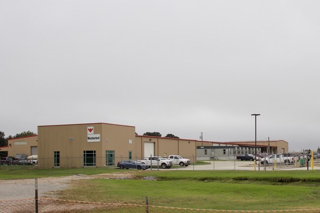
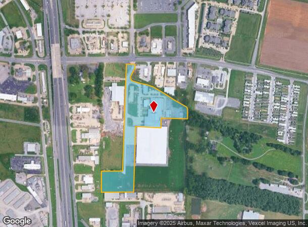
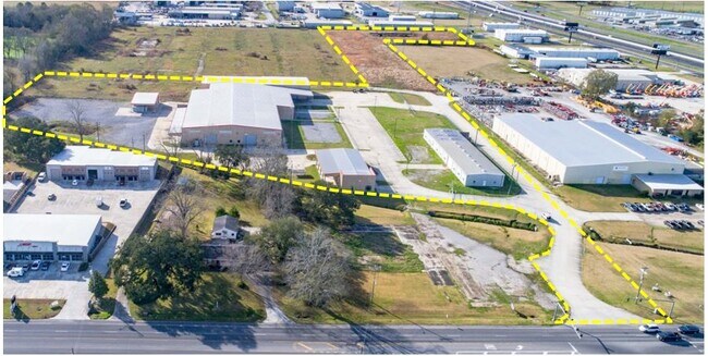
Property Record
200 Saint Nazaire Rd, Broussard, LA 70518
NEARBY LISTINGS FOR SALE OR LEASE
Property Detail
200 Saint Nazaire Rd
Lafayette, LA
LOT 2 SECS 27/34 T10S R5E (13.870 AC) (2021-25236 PLAT)
6170247
Lafayette
Warehouse
Louisiana
X
2
22055C0200J
13.87 AC
2024
Outlying Lafayette Parish
2024
Lafayette
001425
DEMOGRAPHICS near 200 Saint Nazaire Rd
1 Mile
3 Mile
5 Mile
2024 Total Population
1,400
17,071
49,106
2029 Population
1,489
18,015
51,817
Pop Growth 2024-2029
+ 6.36%
+ 5.53%
+ 5.52%
Average Age
39
38
37
2024 Total Households
603
6,561
18,858
HH Growth 2024-2029
+ 6.30%
+ 5.55%
+ 5.58%
Median Household Inc
$51,739
$77,654
$78,595
Avg Household Size
2.30
2.50
2.50
2024 Avg HH Vehicles
1.00
2.00
2.00
Median Home Value
$85,506
$241,962
$243,886
Median Year Built
2010
2001
2001
Nearby Places
Map Layers
Map Styles
 Street
 Aerial
- Restaurants
- Banks
- Shops
- Fitness
- Groceries
PUBLIC TRANSPORTATION
COMMUTER RAIL
Lafayette Amtrak Station (Sunset Limited - Amtrak)
DRIVE
WALK
Distance
Lafayette Amtrak Station (Sunset Limited - Amtrak)
12 min
8.2 mi
AIRPORT
Lafayette Regional/Paul Fournet Field
DRIVE
WALK
Distance
Lafayette Regional/Paul Fournet Field
11 min
7.2 mi
Freight Ports
Port of Iberia
DRIVE
WALK
Distance
Port of Iberia
23 min
16.5 mi
SALE & LEASE HISTORY
LISTING DATE
SALE/LEASE

Oct 29, 2018
For Sale
Mar 05, 2020
For Lease
Nearby Properties
Address
Land Use
TOTAL SIZE
Lot Size
Zoning
Address
Land Use
TOTAL SIZE
Lot Size
Zoning
426,080 SF
35.76 AC
Address
Land Use
TOTAL SIZE
Lot Size
Zoning
200,194 SF
30.80 AC
Address
Land Use
TOTAL SIZE
Lot Size
Zoning
9.02 AC
Address
Land Use
TOTAL SIZE
Lot Size
Zoning
5,625 SF
25.86 AC
Address
Land Use
TOTAL SIZE
Lot Size
Zoning
141,600 SF
24.31 AC
Address
Land Use
TOTAL SIZE
Lot Size
Zoning
5,000 SF
13.09 AC
Address
Land Use
TOTAL SIZE
Lot Size
Zoning
25,886 SF
8.39 AC
Address
Land Use
TOTAL SIZE
Lot Size
Zoning
22,489 SF
6.52 AC
Address
Land Use
TOTAL SIZE
Lot Size
Zoning
1.87 AC
Address
Land Use
TOTAL SIZE
Lot Size
Zoning
283,435 SF
39.25 AC
Address
Land Use
TOTAL SIZE
Lot Size
Zoning
4,800 SF
17.84 AC
Address
Land Use
TOTAL SIZE
Lot Size
Zoning
106,776 SF
17.43 AC
Address
Land Use
TOTAL SIZE
Lot Size
Zoning
84,500 SF
15 AC
Address
Land Use
TOTAL SIZE
Lot Size
Zoning
63,154 SF
6.20 AC
Address
Land Use
TOTAL SIZE
Lot Size
Zoning
Address
Land Use
TOTAL SIZE
Lot Size
Zoning
81,000 SF
20.01 AC
Address
Land Use
TOTAL SIZE
Lot Size
Zoning
23,450 SF
9.30 AC
Address
Land Use
TOTAL SIZE
Lot Size
Zoning
14.66 AC
Address
Land Use
TOTAL SIZE
Lot Size
Zoning
52,080 SF
1.78 AC
Address
Land Use
TOTAL SIZE
Lot Size
Zoning
18,592 SF
12.53 AC
Address
Land Use
TOTAL SIZE
Lot Size
Zoning
20,800 SF
7.10 AC
Address
Land Use
TOTAL SIZE
Lot Size
Zoning
6.64 AC
Address
Land Use
TOTAL SIZE
Lot Size
Zoning
75,393 SF
20.03 AC
Address
Land Use
TOTAL SIZE
Lot Size
Zoning
90,030 SF
16.63 AC
Address
Land Use
TOTAL SIZE
Lot Size
Zoning
55,500 SF
10 AC
Address
Land Use
TOTAL SIZE
Lot Size
Zoning
Address
Land Use
TOTAL SIZE
Lot Size
Zoning
57,585 SF
10.39 AC
Address
Land Use
TOTAL SIZE
Lot Size
Zoning
40,703 SF
4.31 AC
Address
Land Use
TOTAL SIZE
Lot Size
Zoning
49,945 SF
2.29 AC
The World's #1 Commercial Real Estate Marketplace
Connect with us
© 2026 CoStar Group
The information above has been obtained from sources believed reliable. While we do not doubt its accuracy we have not verified it and make no guarantee, warranty or representation about it. It is your responsibility to independently confirm its accuracy and completeness. Any projections, opinions, assumptions, or estimates used are for example only and do not represent the current or future performance of the property. The value of this transaction to you depends on tax and other factors which should be evaluated by your tax, financial, and legal advisors. You and your advisors should conduct a careful, independent investigation of the property to determine to your satisfaction the suitability of the property for your needs.