Property Record
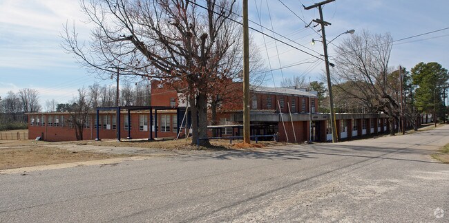
200 School St, Gaston, NC 27832


Property Detail
200 School St
01-09967
GASTON HIGH SCHOOL
Commercialnec
NORTHAMPTON
AR
North Carolina
B and X Area of moderate flood hazard, usually the area between the limits of the 100-year and 500-year floods.
11.32 AC
2025
North Carolina Northeast Area
2025
Other Market Areas
920401
Roanoke Rapids, NC
1,625 SF
NEARBY LISTINGS FOR SALE OR LEASE
-
-
View all Gaston listings for sale on LoopNet.com
DEMOGRAPHICS near 200 School St
1 mile
3 mile
5 mile
2025 Total Population
1,073
9,542
20,890
2030 Population
1,041
9,174
20,105
Pop Growth 2025-2030
(2.98%)
(3.86%)
(3.76%)
Average Age
45
41
42
2025 Total Households
464
3,892
8,905
HH Growth 2025-2030
(3.23%)
(4.01%)
(3.85%)
Median Household Inc
$41,724
$55,132
$50,398
Avg Household Size
2.20
2.40
2.30
2025 Avg HH Vehicles
2.00
2.00
2.00
Median Home Value
$107,558
$137,515
$131,640
Median Year Built
1982
1967
1975
Nearby Places
Map Layers
Map Styles
 Street
 Aerial
Transit
 Traffic
 Biking
Places
Listings with unknown addresses are not visible on the map
- Restaurants
- Banks
- Shops
- Fitness
- Groceries
Nearby Properties
Address
Land Use
TOTAL SIZE
Lot Size
Zoning
Address
Land Use
TOTAL SIZE
Lot Size
Zoning
3,600 SF
120.17 AC
LI
Address
Land Use
TOTAL SIZE
Lot Size
Zoning
94,328 SF
26.40 AC
RRR8
Address
Land Use
TOTAL SIZE
Lot Size
Zoning
26,530 SF
196.49 AC
RRI2
Address
Land Use
TOTAL SIZE
Lot Size
Zoning
122,670 SF
56.57 AC
AR
Address
Land Use
TOTAL SIZE
Lot Size
Zoning
60,043 SF
1.58 AC
RRR6
Address
Land Use
TOTAL SIZE
Lot Size
Zoning
69,793 SF
23.96 AC
Address
Land Use
TOTAL SIZE
Lot Size
Zoning
6,655 SF
10.02 AC
Address
Land Use
TOTAL SIZE
Lot Size
Zoning
38,176 SF
6.20 AC
RRR6
Address
Land Use
TOTAL SIZE
Lot Size
Zoning
10,114 SF
4.45 AC
RRR6
Address
Land Use
TOTAL SIZE
Lot Size
Zoning
6,840 SF
1.82 AC
RRR20
Address
Land Use
TOTAL SIZE
Lot Size
Zoning
10,920 SF
1.92 AC
RRR8
Address
Land Use
TOTAL SIZE
Lot Size
Zoning
25,074 SF
0.32 AC
RRB2
Address
Land Use
TOTAL SIZE
Lot Size
Zoning
6,324 SF
15.60 AC
AR
Address
Land Use
TOTAL SIZE
Lot Size
Zoning
2,760 SF
6.17 AC
RRR6
Address
Land Use
TOTAL SIZE
Lot Size
Zoning
1,728 SF
15.13 AC
Address
Land Use
TOTAL SIZE
Lot Size
Zoning
16,281 SF
16.56 AC
RRR8
Address
Land Use
TOTAL SIZE
Lot Size
Zoning
2,729 SF
21.46 AC
Address
Land Use
TOTAL SIZE
Lot Size
Zoning
24,783 SF
1.03 AC
RRR6
Address
Land Use
TOTAL SIZE
Lot Size
Zoning
3,960 SF
Address
Land Use
TOTAL SIZE
Lot Size
Zoning
21,982 SF
0.72 AC
RRB1
Address
Land Use
TOTAL SIZE
Lot Size
Zoning
23,312 SF
9.73 AC
HB
Address
Land Use
TOTAL SIZE
Lot Size
Zoning
16,180 SF
4.13 AC
RRR8
Address
Land Use
TOTAL SIZE
Lot Size
Zoning
1,760 SF
1.40 AC
RRR6
Address
Land Use
TOTAL SIZE
Lot Size
Zoning
24,780 SF
0.64 AC
RRB1
Address
Land Use
TOTAL SIZE
Lot Size
Zoning
1,172 SF
5.56 AC
Address
Land Use
TOTAL SIZE
Lot Size
Zoning
35,128 SF
3.33 AC
Address
Land Use
TOTAL SIZE
Lot Size
Zoning
17,915 SF
4.13 AC
RRR8
Address
Land Use
TOTAL SIZE
Lot Size
Zoning
22,900 SF
10.60 AC
Address
Land Use
TOTAL SIZE
Lot Size
Zoning
16,811 SF
0.24 AC
RRB1
Address
Land Use
TOTAL SIZE
Lot Size
Zoning
16,568 SF
14.44 AC
RRI2
The World's #1 Commercial Real Estate Marketplace
Connect with us
© 2026 CoStar Group
The information above has been obtained from sources believed reliable. While we do not doubt its accuracy we have not verified it and make no guarantee, warranty or representation about it. It is your responsibility to independently confirm its accuracy and completeness. Any projections, opinions, assumptions, or estimates used are for example only and do not represent the current or future performance of the property. The value of this transaction to you depends on tax and other factors which should be evaluated by your tax, financial, and legal advisors. You and your advisors should conduct a careful, independent investigation of the property to determine to your satisfaction the suitability of the property for your needs.