Property Record
200 Singleton Rd, Waxahachie, TX 75165
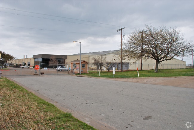

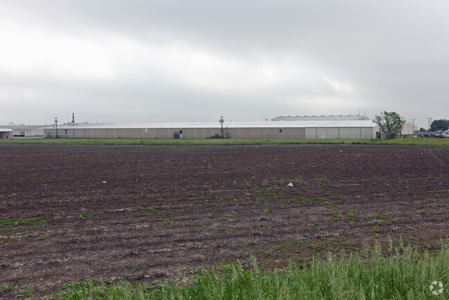
Property Detail
200 Singleton Rd
Dallas-Fort Worth-Arlington, TX
LOT 1R BLK A INTERNATIONAL ALUMINUM CORP 33.175 AC
174466
ELLIS
Agriculturalland
Texas
B and X Area of moderate flood hazard, usually the area between the limits of the 100-year and 500-year floods.
1r
2024
33.17 AC
2025
SW Dallas/US 67
060212
Dallas/Ft Worth
112,365 SF
NEARBY LISTINGS FOR SALE OR LEASE
DEMOGRAPHICS near 200 Singleton Rd
1 mile
3 mile
5 mile
2025 Total Population
3,182
40,252
65,225
2030 Population
3,655
47,150
76,323
Pop Growth 2025-2030
+ 14.86%
+ 17.14%
+ 17.01%
Average Age
36
37
37
2025 Total Households
1,435
14,296
22,708
HH Growth 2025-2030
+ 14.91%
+ 17.09%
+ 17.04%
Median Household Inc
$63,302
$85,989
$85,610
Avg Household Size
2.20
2.70
2.80
2025 Avg HH Vehicles
2.00
2.00
2.00
Median Home Value
$307,143
$356,924
$371,002
Median Year Built
1998
2003
2002
Nearby Places
Map Layers
Map Styles
 Street
 Aerial
Transit
 Traffic
 Biking
Places
Listings with unknown addresses are not visible on the map
- Restaurants
- Banks
- Shops
- Fitness
- Groceries
PUBLIC TRANSPORTATION
AIRPORT
Dallas Love Field
Drive
Walk
Distance
Dallas Love Field
44 min
31.4 mi
Freight Ports
Port of Shreveport
Drive
Walk
Distance
Port of Shreveport
230 min
212.6 mi
Nearby Properties
Address
Land Use
TOTAL SIZE
Lot Size
Zoning
Address
Land Use
TOTAL SIZE
Lot Size
Zoning
488,705 SF
43.76 AC
Address
Land Use
TOTAL SIZE
Lot Size
Zoning
413,618 SF
94.72 AC
Address
Land Use
TOTAL SIZE
Lot Size
Zoning
630,460 SF
71.82 AC
Address
Land Use
TOTAL SIZE
Lot Size
Zoning
146,074 SF
42.83 AC
Address
Land Use
TOTAL SIZE
Lot Size
Zoning
448,643 SF
8.93 AC
Address
Land Use
TOTAL SIZE
Lot Size
Zoning
643,064 SF
42.15 AC
Address
Land Use
TOTAL SIZE
Lot Size
Zoning
408,068 SF
7.42 AC
Address
Land Use
TOTAL SIZE
Lot Size
Zoning
259,166 SF
11.07 AC
Address
Land Use
TOTAL SIZE
Lot Size
Zoning
675,375 SF
59.26 AC
Address
Land Use
TOTAL SIZE
Lot Size
Zoning
424,436 SF
11.87 AC
Address
Land Use
TOTAL SIZE
Lot Size
Zoning
285,936 SF
12.66 AC
Address
Land Use
TOTAL SIZE
Lot Size
Zoning
193,837 SF
10.41 AC
Address
Land Use
TOTAL SIZE
Lot Size
Zoning
258,147 SF
12.40 AC
Address
Land Use
TOTAL SIZE
Lot Size
Zoning
177,000 SF
20.25 AC
Address
Land Use
TOTAL SIZE
Lot Size
Zoning
708,800 SF
149.18 AC
Address
Land Use
TOTAL SIZE
Lot Size
Zoning
198,180 SF
11.48 AC
Address
Land Use
TOTAL SIZE
Lot Size
Zoning
1,123,347 SF
74.97 AC
Address
Land Use
TOTAL SIZE
Lot Size
Zoning
182,574 SF
7.79 AC
Address
Land Use
TOTAL SIZE
Lot Size
Zoning
413,050 SF
54.30 AC
Address
Land Use
TOTAL SIZE
Lot Size
Zoning
134,530 SF
12.11 AC
Address
Land Use
TOTAL SIZE
Lot Size
Zoning
107,800 SF
18.46 AC
Address
Land Use
TOTAL SIZE
Lot Size
Zoning
178,880 SF
5.51 AC
Address
Land Use
TOTAL SIZE
Lot Size
Zoning
150,886 SF
11.02 AC
Address
Land Use
TOTAL SIZE
Lot Size
Zoning
63,720 SF
17.38 AC
Address
Land Use
TOTAL SIZE
Lot Size
Zoning
85,823 SF
56.24 AC
Address
Land Use
TOTAL SIZE
Lot Size
Zoning
118,782 SF
5.11 AC
Address
Land Use
TOTAL SIZE
Lot Size
Zoning
326,740 SF
23.01 AC
Address
Land Use
TOTAL SIZE
Lot Size
Zoning
352,350 SF
18.78 AC
Address
Land Use
TOTAL SIZE
Lot Size
Zoning
568,234 SF
65.79 AC
Address
Land Use
TOTAL SIZE
Lot Size
Zoning
886,858 SF
8.60 AC
The World's #1 Commercial Real Estate Marketplace
Connect with us
© 2026 CoStar Group
The information above has been obtained from sources believed reliable. While we do not doubt its accuracy we have not verified it and make no guarantee, warranty or representation about it. It is your responsibility to independently confirm its accuracy and completeness. Any projections, opinions, assumptions, or estimates used are for example only and do not represent the current or future performance of the property. The value of this transaction to you depends on tax and other factors which should be evaluated by your tax, financial, and legal advisors. You and your advisors should conduct a careful, independent investigation of the property to determine to your satisfaction the suitability of the property for your needs.