Property Record
200 Smith St, Waltham, MA 02451
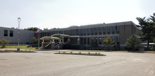


Property Detail
200 Smith St
WALT-000006-000002-000002
Middlesex
Officebuilding
Massachusetts
A Areas with a 1% annual chance of flooding and a 26% chance of flooding over the life of a 30-year mortgage.
2
2025
36.56 AC
2025
Waltham/Watertown
368101
Boston
484,464 SF
Boston-Cambridge-Newton, MA-NH
NEARBY LISTINGS FOR SALE OR LEASE
DEMOGRAPHICS near 200 Smith St
1 mile
3 mile
5 mile
2025 Total Population
5,616
61,481
215,889
2030 Population
5,913
64,033
223,948
Pop Growth 2025-2030
+ 5.29%
+ 4.15%
+ 3.73%
Average Age
44
41
42
2025 Total Households
2,013
22,155
83,203
HH Growth 2025-2030
+ 5.41%
+ 4.36%
+ 3.84%
Median Household Inc
$172,589
$151,131
$146,472
Avg Household Size
2.60
2.50
2.50
2025 Avg HH Vehicles
2.00
2.00
2.00
Median Home Value
$840,579
$927,598
$929,529
Median Year Built
1968
1967
1956
Nearby Places
Map Layers
Map Styles
 Street
 Aerial
Layers
 Traffic
 Biking
Places
Listings with unknown addresses are not visible on the map
- Restaurants
- Banks
- Shops
- Fitness
- Groceries
PUBLIC TRANSPORTATION
COMMUTER RAIL
Kendal Green (Fitchburg/South Acton Line - Massachusetts Bay Transportation Authority Commuter Rail (Purple Line))
Drive
Walk
Distance
Kendal Green (Fitchburg/South Acton Line - Massachusetts Bay Transportation Authority Commuter Rail (Purple Line))
12 min
5.7 mi
Hastings (Fitchburg/South Acton Line - Massachusetts Bay Transportation Authority Commuter Rail (Purple Line))
Drive
Walk
Distance
Hastings (Fitchburg/South Acton Line - Massachusetts Bay Transportation Authority Commuter Rail (Purple Line))
14 min
6.4 mi
AIRPORT
General Edward Lawrence Logan International
Drive
Walk
Distance
General Edward Lawrence Logan International
30 min
17.2 mi
Manchester Boston Regional
Drive
Walk
Distance
Manchester Boston Regional
55 min
46.0 mi
Nearby Properties
Address
Land Use
TOTAL SIZE
Lot Size
Zoning
Address
Land Use
TOTAL SIZE
Lot Size
Zoning
776,099 SF
35.70 AC
Address
Land Use
TOTAL SIZE
Lot Size
Zoning
447,312 SF
62.01 AC
Address
Land Use
TOTAL SIZE
Lot Size
Zoning
561,437 SF
33.53 AC
Address
Land Use
TOTAL SIZE
Lot Size
Zoning
472,329 SF
22.11 AC
CD
Address
Land Use
TOTAL SIZE
Lot Size
Zoning
190,308 SF
17.46 AC
CD
Address
Land Use
TOTAL SIZE
Lot Size
Zoning
198,051 SF
11.56 AC
CR
Address
Land Use
TOTAL SIZE
Lot Size
Zoning
336,306 SF
7.54 AC
Address
Land Use
TOTAL SIZE
Lot Size
Zoning
25,000 SF
25.73 AC
RD
Address
Land Use
TOTAL SIZE
Lot Size
Zoning
79.60 AC
SD
Address
Land Use
TOTAL SIZE
Lot Size
Zoning
293,084 SF
5.01 AC
1
Address
Land Use
TOTAL SIZE
Lot Size
Zoning
238,065 SF
1.79 AC
Address
Land Use
TOTAL SIZE
Lot Size
Zoning
272,445 SF
6.40 AC
Address
Land Use
TOTAL SIZE
Lot Size
Zoning
282,014 SF
15.57 AC
Address
Land Use
TOTAL SIZE
Lot Size
Zoning
269,692 SF
15.37 AC
Address
Land Use
TOTAL SIZE
Lot Size
Zoning
344,469 SF
54.49 AC
Address
Land Use
TOTAL SIZE
Lot Size
Zoning
442,743 SF
27.11 AC
Address
Land Use
TOTAL SIZE
Lot Size
Zoning
164,072 SF
43.80 AC
Address
Land Use
TOTAL SIZE
Lot Size
Zoning
212,684 SF
54.49 AC
Address
Land Use
TOTAL SIZE
Lot Size
Zoning
30.69 AC
Address
Land Use
TOTAL SIZE
Lot Size
Zoning
342,677 SF
56.46 AC
ND
Address
Land Use
TOTAL SIZE
Lot Size
Zoning
21.99 AC
Address
Land Use
TOTAL SIZE
Lot Size
Zoning
11.25 AC
PD-6
Address
Land Use
TOTAL SIZE
Lot Size
Zoning
124,950 SF
1.69 AC
Address
Land Use
TOTAL SIZE
Lot Size
Zoning
224,892 SF
20.52 AC
Address
Land Use
TOTAL SIZE
Lot Size
Zoning
286,462 SF
15.94 AC
Address
Land Use
TOTAL SIZE
Lot Size
Zoning
210,423 SF
26.39 AC
Address
Land Use
TOTAL SIZE
Lot Size
Zoning
197,400 SF
4.29 AC
Address
Land Use
TOTAL SIZE
Lot Size
Zoning
288,975 SF
5 AC
Address
Land Use
TOTAL SIZE
Lot Size
Zoning
64.56 AC
Address
Land Use
TOTAL SIZE
Lot Size
Zoning
618.53 AC
The World's #1 Commercial Real Estate Marketplace
Connect with us
© 2026 CoStar Group
The information above has been obtained from sources believed reliable. While we do not doubt its accuracy we have not verified it and make no guarantee, warranty or representation about it. It is your responsibility to independently confirm its accuracy and completeness. Any projections, opinions, assumptions, or estimates used are for example only and do not represent the current or future performance of the property. The value of this transaction to you depends on tax and other factors which should be evaluated by your tax, financial, and legal advisors. You and your advisors should conduct a careful, independent investigation of the property to determine to your satisfaction the suitability of the property for your needs.