Property Record
200 Speer St, Azle, TX 76020
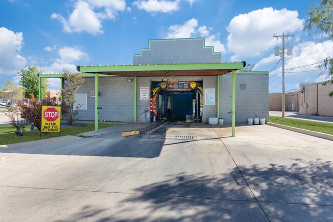

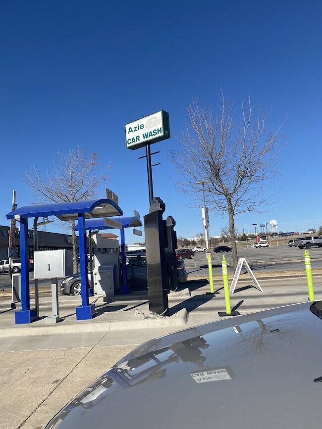
Property Detail
200 Speer St
Dallas-Fort Worth-Arlington, TX
ACRES: 0.700 LOT: 8 SUBD: LEAH SEE ADDITION
14500-001-008-00
Parker
Commercialnec
Texas
B and X Area of moderate flood hazard, usually the area between the limits of the 100-year and 500-year floods.
8
2024
0.70 AC
2025
Parker County
140408
Dallas/Ft Worth
4,610 SF
NEARBY LISTINGS FOR SALE OR LEASE
-
-
View all Azle listings for sale on LoopNet.com
DEMOGRAPHICS near 200 Speer St
1 mile
3 mile
5 mile
2024 Total Population
5,333
23,678
41,190
2029 Population
5,991
26,971
47,912
Pop Growth 2024-2029
+ 12.34%
+ 13.91%
+ 16.32%
Average Age
39
40
41
2024 Total Households
2,021
8,876
15,353
HH Growth 2024-2029
+ 12.22%
+ 13.84%
+ 16.09%
Median Household Inc
$71,311
$75,626
$81,003
Avg Household Size
2.60
2.60
2.60
2024 Avg HH Vehicles
2.00
2.00
2.00
Median Home Value
$220,095
$252,085
$301,282
Median Year Built
1985
1987
1992
Nearby Places
Map Layers
Map Styles
 Street
 Aerial
Transit
 Traffic
 Biking
Places
Listings with unknown addresses are not visible on the map
- Restaurants
- Banks
- Shops
- Fitness
- Groceries
PUBLIC TRANSPORTATION
AIRPORT
Dallas-Fort Worth International
Drive
Walk
Distance
Dallas-Fort Worth International
50 min
38.5 mi
SALE & LEASE HISTORY
LISTING DATE
SALE/LEASE

Oct 13, 2023
For Sale
Feb 14, 2018
For Sale
Nearby Properties
Address
Land Use
TOTAL SIZE
Lot Size
Zoning
Address
Land Use
TOTAL SIZE
Lot Size
Zoning
504.76 AC
Address
Land Use
TOTAL SIZE
Lot Size
Zoning
281,946 SF
16.01 AC
Address
Land Use
TOTAL SIZE
Lot Size
Zoning
228,201 SF
9.96 AC
Address
Land Use
TOTAL SIZE
Lot Size
Zoning
208,984 SF
14.42 AC
Address
Land Use
TOTAL SIZE
Lot Size
Zoning
262,793 SF
67.85 AC
Address
Land Use
TOTAL SIZE
Lot Size
Zoning
185,807 SF
14.03 AC
Address
Land Use
TOTAL SIZE
Lot Size
Zoning
43,610 SF
15.02 AC
Address
Land Use
TOTAL SIZE
Lot Size
Zoning
28,901 SF
14.03 AC
Address
Land Use
TOTAL SIZE
Lot Size
Zoning
62,068 SF
18.93 AC
Address
Land Use
TOTAL SIZE
Lot Size
Zoning
119.88 AC
Address
Land Use
TOTAL SIZE
Lot Size
Zoning
36,452 SF
10 AC
Address
Land Use
TOTAL SIZE
Lot Size
Zoning
221.50 AC
Address
Land Use
TOTAL SIZE
Lot Size
Zoning
105,385 SF
20 AC
Address
Land Use
TOTAL SIZE
Lot Size
Zoning
50,103 SF
11.48 AC
Address
Land Use
TOTAL SIZE
Lot Size
Zoning
62,536 SF
30.53 AC
Address
Land Use
TOTAL SIZE
Lot Size
Zoning
268.17 AC
Address
Land Use
TOTAL SIZE
Lot Size
Zoning
32,091 SF
117.44 AC
Address
Land Use
TOTAL SIZE
Lot Size
Zoning
1,728 SF
17.73 AC
Address
Land Use
TOTAL SIZE
Lot Size
Zoning
90,949 SF
5.32 AC
Address
Land Use
TOTAL SIZE
Lot Size
Zoning
87.74 AC
Address
Land Use
TOTAL SIZE
Lot Size
Zoning
32,334 SF
3.52 AC
Address
Land Use
TOTAL SIZE
Lot Size
Zoning
69,227 SF
19.02 AC
Address
Land Use
TOTAL SIZE
Lot Size
Zoning
62,538 SF
9.19 AC
Address
Land Use
TOTAL SIZE
Lot Size
Zoning
82.25 AC
Address
Land Use
TOTAL SIZE
Lot Size
Zoning
21,141 SF
4.14 AC
Address
Land Use
TOTAL SIZE
Lot Size
Zoning
33,930 SF
18.70 AC
Address
Land Use
TOTAL SIZE
Lot Size
Zoning
71,740 SF
1.75 AC
Address
Land Use
TOTAL SIZE
Lot Size
Zoning
148.37 AC
Address
Land Use
TOTAL SIZE
Lot Size
Zoning
44,264 SF
2.57 AC
Address
Land Use
TOTAL SIZE
Lot Size
Zoning
42,206 SF
2.67 AC
The World's #1 Commercial Real Estate Marketplace
Connect with us
© 2026 CoStar Group
The information above has been obtained from sources believed reliable. While we do not doubt its accuracy we have not verified it and make no guarantee, warranty or representation about it. It is your responsibility to independently confirm its accuracy and completeness. Any projections, opinions, assumptions, or estimates used are for example only and do not represent the current or future performance of the property. The value of this transaction to you depends on tax and other factors which should be evaluated by your tax, financial, and legal advisors. You and your advisors should conduct a careful, independent investigation of the property to determine to your satisfaction the suitability of the property for your needs.