Property Record
200 Sr, Yulee, FL 32097
Property Detail
200 Sr
Jacksonville, FL
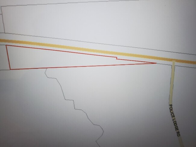
PT SE1/4 OF SW1/4, PT S1/2 OF SE1/4 BEING PAR 3 IN OR 2522/1033 LYING SOUTH OF SR 200 (EX R/W CASE# 2001-CA-467, OR 2576/1044)
04-2N-26-0000-0005-0010
NASSAU
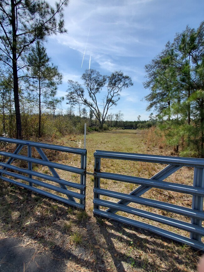
Vacantlandnec
Florida
OR
5
A Areas with a 1% annual chance of flooding and a 26% chance of flooding over the life of a 30-year mortgage.
5.54 AC
2025
Nassau County
2025
Jacksonville (Florida)
050304
NEARBY LISTINGS FOR SALE OR LEASE
-
-
View all Yulee listings for sale on LoopNet.com
DEMOGRAPHICS near 200 Sr
1 mile
3 mile
5 mile
2025 Total Population
349
4,239
11,244
2030 Population
400
4,881
13,163
Pop Growth 2025-2030
+ 14.61%
+ 15.15%
+ 17.07%
Average Age
36
35
37
2025 Total Households
109
1,331
3,481
HH Growth 2025-2030
+ 15.60%
+ 15.25%
+ 16.83%
Median Household Inc
$115,908
$112,773
$111,907
Avg Household Size
3.10
3.20
2.90
2025 Avg HH Vehicles
2.00
2.00
2.00
Median Home Value
$410,294
$416,631
$350,409
Median Year Built
2010
2011
2011
Nearby Places
Map Layers
Map Styles
 Street
 Aerial
Transit
 Traffic
 Biking
Places
Listings with unknown addresses are not visible on the map
- Restaurants
- Banks
- Shops
- Fitness
- Groceries
PUBLIC TRANSPORTATION
AIRPORT
Jacksonville International
Drive
Walk
Distance
Jacksonville International
22 min
15.9 mi
Freight Ports
Jacksonville Port
Drive
Walk
Distance
Jacksonville Port
32 min
25.3 mi
SALE & LEASE HISTORY
LISTING DATE
SALE/LEASE

Jan 31, 2021
For Sale
Nearby Properties
Address
Land Use
TOTAL SIZE
Lot Size
Zoning
Address
Land Use
TOTAL SIZE
Lot Size
Zoning
104,064 SF
5.27 AC
CHT
Address
Land Use
TOTAL SIZE
Lot Size
Zoning
529.22 AC
PUD
Address
Land Use
TOTAL SIZE
Lot Size
Zoning
558 AC
OR
Address
Land Use
TOTAL SIZE
Lot Size
Zoning
616 AC
OR
Address
Land Use
TOTAL SIZE
Lot Size
Zoning
471 AC
OR
Address
Land Use
TOTAL SIZE
Lot Size
Zoning
528.64 AC
OR
Address
Land Use
TOTAL SIZE
Lot Size
Zoning
392.52 AC
OR
Address
Land Use
TOTAL SIZE
Lot Size
Zoning
389.09 AC
OR
Address
Land Use
TOTAL SIZE
Lot Size
Zoning
58.15 AC
PUD
Address
Land Use
TOTAL SIZE
Lot Size
Zoning
8,486 SF
4.20 AC
OR
Address
Land Use
TOTAL SIZE
Lot Size
Zoning
27.56 AC
PUD
Address
Land Use
TOTAL SIZE
Lot Size
Zoning
1,260 SF
43 AC
OR
Address
Land Use
TOTAL SIZE
Lot Size
Zoning
281 AC
OR
Address
Land Use
TOTAL SIZE
Lot Size
Zoning
271 AC
OR
Address
Land Use
TOTAL SIZE
Lot Size
Zoning
250 AC
OR
Address
Land Use
TOTAL SIZE
Lot Size
Zoning
6,528 SF
3.50 AC
CG
Address
Land Use
TOTAL SIZE
Lot Size
Zoning
241 AC
OR
Address
Land Use
TOTAL SIZE
Lot Size
Zoning
131.13 AC
OR
Address
Land Use
TOTAL SIZE
Lot Size
Zoning
4,800 SF
2.54 AC
CG
Address
Land Use
TOTAL SIZE
Lot Size
Zoning
169.91 AC
OR
Address
Land Use
TOTAL SIZE
Lot Size
Zoning
202.18 AC
OR
Address
Land Use
TOTAL SIZE
Lot Size
Zoning
13 AC
PUD
Address
Land Use
TOTAL SIZE
Lot Size
Zoning
176.43 AC
OR
Address
Land Use
TOTAL SIZE
Lot Size
Zoning
160 AC
OR
Address
Land Use
TOTAL SIZE
Lot Size
Zoning
151.70 AC
OR
Address
Land Use
TOTAL SIZE
Lot Size
Zoning
2,995 SF
1 AC
RS-E
Address
Land Use
TOTAL SIZE
Lot Size
Zoning
440 SF
3.99 AC
CG
Address
Land Use
TOTAL SIZE
Lot Size
Zoning
2,878 SF
0.13 AC
PUD
Address
Land Use
TOTAL SIZE
Lot Size
Zoning
3,034 SF
0.17 AC
PUD
Address
Land Use
TOTAL SIZE
Lot Size
Zoning
3,108 SF
0.19 AC
PUD
The World's #1 Commercial Real Estate Marketplace
Connect with us
© 2026 CoStar Group
The information above has been obtained from sources believed reliable. While we do not doubt its accuracy we have not verified it and make no guarantee, warranty or representation about it. It is your responsibility to independently confirm its accuracy and completeness. Any projections, opinions, assumptions, or estimates used are for example only and do not represent the current or future performance of the property. The value of this transaction to you depends on tax and other factors which should be evaluated by your tax, financial, and legal advisors. You and your advisors should conduct a careful, independent investigation of the property to determine to your satisfaction the suitability of the property for your needs.