Property Record
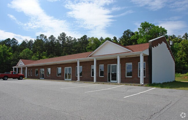
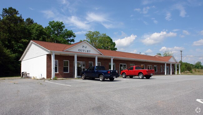
200 Us Highway 70 E, Hildebran, NC 28637


Property Detail
200 Us Highway 70 E
27933
200 US HWY 70 E HILDEBRAN, NC 28637
Realpropertynec
Burke
HIGHWAY BU
North Carolina
B and X Area of moderate flood hazard, usually the area between the limits of the 100-year and 500-year floods.
1.81 AC
2025
Burke County
2025
Charlotte
021100
Hickory-Lenoir-Morganton, NC
4,800 SF
NEARBY LISTINGS FOR SALE OR LEASE
-
-
View all Hildebran listings for sale on LoopNet.com
DEMOGRAPHICS near 200 Us Highway 70 E
1 mile
3 mile
5 mile
2025 Total Population
2,277
15,911
47,800
2030 Population
2,323
16,278
48,971
Pop Growth 2025-2030
+ 2.02%
+ 2.31%
+ 2.45%
Average Age
42
41
42
2025 Total Households
934
6,552
19,243
HH Growth 2025-2030
+ 2.03%
+ 2.40%
+ 2.57%
Median Household Inc
$52,357
$48,666
$57,821
Avg Household Size
2.40
2.40
2.40
2025 Avg HH Vehicles
2.00
2.00
2.00
Median Home Value
$169,399
$188,616
$230,510
Median Year Built
1969
1974
1976
Nearby Places
Map Layers
Map Styles
 Street
 Aerial
Transit
 Traffic
 Biking
Places
Listings with unknown addresses are not visible on the map
- Restaurants
- Banks
- Shops
- Fitness
- Groceries
Nearby Properties
Address
Land Use
TOTAL SIZE
Lot Size
Zoning
Address
Land Use
TOTAL SIZE
Lot Size
Zoning
311,263 SF
37.58 AC
IND
Address
Land Use
TOTAL SIZE
Lot Size
Zoning
7,240 SF
INDUSTRIAL
Address
Land Use
TOTAL SIZE
Lot Size
Zoning
90,440 SF
5.17 AC
OI
Address
Land Use
TOTAL SIZE
Lot Size
Zoning
73,872 SF
NO ZONING
Address
Land Use
TOTAL SIZE
Lot Size
Zoning
301,264 SF
19.88 AC
I
Address
Land Use
TOTAL SIZE
Lot Size
Zoning
73,702 SF
13.37 AC
C-2
Address
Land Use
TOTAL SIZE
Lot Size
Zoning
20,503 SF
16.55 AC
INDUSTRIAL
Address
Land Use
TOTAL SIZE
Lot Size
Zoning
173,730 SF
16.80 AC
IND
Address
Land Use
TOTAL SIZE
Lot Size
Zoning
272,735 SF
21.83 AC
IND
Address
Land Use
TOTAL SIZE
Lot Size
Zoning
59,716 SF
30.60 AC
IND
Address
Land Use
TOTAL SIZE
Lot Size
Zoning
52,540 SF
6.27 AC
C-3
Address
Land Use
TOTAL SIZE
Lot Size
Zoning
95,509 SF
C-3
Address
Land Use
TOTAL SIZE
Lot Size
Zoning
85,988 SF
9.67 AC
ED
Address
Land Use
TOTAL SIZE
Lot Size
Zoning
10,086 SF
8.61 AC
R-5
Address
Land Use
TOTAL SIZE
Lot Size
Zoning
240,210 SF
11.64 AC
I
Address
Land Use
TOTAL SIZE
Lot Size
Zoning
129,280 SF
20.19 AC
IND
Address
Land Use
TOTAL SIZE
Lot Size
Zoning
29.21 AC
R-2
Address
Land Use
TOTAL SIZE
Lot Size
Zoning
51,668 SF
CENTRAL BU
Address
Land Use
TOTAL SIZE
Lot Size
Zoning
17,248 SF
INDUSTRIAL
Address
Land Use
TOTAL SIZE
Lot Size
Zoning
151,117 SF
26.59 AC
GENERAL MA
Address
Land Use
TOTAL SIZE
Lot Size
Zoning
19,107 SF
R-3 DIST -
Address
Land Use
TOTAL SIZE
Lot Size
Zoning
94,782 SF
64.41 AC
IND
Address
Land Use
TOTAL SIZE
Lot Size
Zoning
335,352 SF
55.48 AC
INDUSTRIAL
Address
Land Use
TOTAL SIZE
Lot Size
Zoning
7,860 SF
5.56 AC
R-4
Address
Land Use
TOTAL SIZE
Lot Size
Zoning
56,240 SF
15.07 AC
IND
Address
Land Use
TOTAL SIZE
Lot Size
Zoning
44,046 SF
4.61 AC
R-4
Address
Land Use
TOTAL SIZE
Lot Size
Zoning
6,310 SF
CENTRAL BU
Address
Land Use
TOTAL SIZE
Lot Size
Zoning
64,928 SF
24.49 AC
ED
Address
Land Use
TOTAL SIZE
Lot Size
Zoning
12,472 SF
RESIDENTIA
Address
Land Use
TOTAL SIZE
Lot Size
Zoning
57,342 SF
2.35 AC
C-2
The World's #1 Commercial Real Estate Marketplace
Connect with us
© 2026 CoStar Group
The information above has been obtained from sources believed reliable. While we do not doubt its accuracy we have not verified it and make no guarantee, warranty or representation about it. It is your responsibility to independently confirm its accuracy and completeness. Any projections, opinions, assumptions, or estimates used are for example only and do not represent the current or future performance of the property. The value of this transaction to you depends on tax and other factors which should be evaluated by your tax, financial, and legal advisors. You and your advisors should conduct a careful, independent investigation of the property to determine to your satisfaction the suitability of the property for your needs.