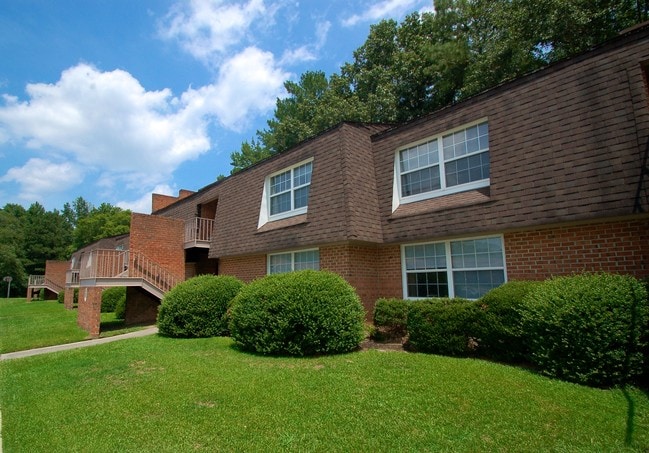
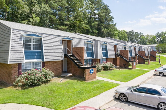
Property Record
200 Verdant Dr, Greenville, NC 27858

NEARBY LISTINGS FOR SALE OR LEASE
Property Detail
200 Verdant Dr
Greenville, NC
General Bldg & Masonry Contrac
008620
RIVERS EDGE WEST
Gardenaptcourtapt5plusunits
Pitt
AE
North Carolina
3720469700K
1,2
2025
5.76 AC
2025
Southeast Greenville
000201
Other Market Areas
24,508 SF
DEMOGRAPHICS near 200 Verdant Dr
1 Mile
3 Mile
5 Mile
2024 Total Population
8,854
49,250
96,520
2029 Population
9,429
52,227
101,522
Pop Growth 2024-2029
+ 6.49%
+ 6.04%
+ 5.18%
Average Age
33
34
36
2024 Total Households
4,339
21,087
41,453
HH Growth 2024-2029
+ 6.89%
+ 6.76%
+ 5.71%
Median Household Inc
$32,151
$38,037
$41,446
Avg Household Size
2.00
2.10
2.20
2024 Avg HH Vehicles
2.00
2.00
2.00
Median Home Value
$172,466
$191,487
$186,369
Median Year Built
1983
1986
1991
Nearby Places
Map Layers
Map Styles
 Street
 Aerial
- Restaurants
- Banks
- Shops
- Fitness
- Groceries
PUBLIC TRANSPORTATION
AIRPORT
Pitt-Greenville
DRIVE
WALK
Distance
Pitt-Greenville
14 min
8.2 mi
Freight Ports
Port of Morehead City
DRIVE
WALK
Distance
Port of Morehead City
127 min
84.2 mi
Nearby Properties
Address
Land Use
TOTAL SIZE
Lot Size
Zoning
Address
Land Use
TOTAL SIZE
Lot Size
Zoning
1,555,005 SF
61.20 AC
OR
Address
Land Use
TOTAL SIZE
Lot Size
Zoning
207,166 SF
36.57 AC
OR
Address
Land Use
TOTAL SIZE
Lot Size
Zoning
780,261 SF
36.60 AC
OR
Address
Land Use
TOTAL SIZE
Lot Size
Zoning
1,002,223 SF
39.45 AC
OR
Address
Land Use
TOTAL SIZE
Lot Size
Zoning
473,026 SF
0.69 AC
OR
Address
Land Use
TOTAL SIZE
Lot Size
Zoning
275,664 SF
93.97 AC
R6
Address
Land Use
TOTAL SIZE
Lot Size
Zoning
339,992 SF
115.67 AC
CH
Address
Land Use
TOTAL SIZE
Lot Size
Zoning
682,180 SF
4.57 AC
CDF-UC
Address
Land Use
TOTAL SIZE
Lot Size
Zoning
512,349 SF
39.27 AC
CG
Address
Land Use
TOTAL SIZE
Lot Size
Zoning
282,000 SF
0.94 AC
OR
Address
Land Use
TOTAL SIZE
Lot Size
Zoning
180,500 SF
2.17 AC
CD
Address
Land Use
TOTAL SIZE
Lot Size
Zoning
33,791 SF
21.01 AC
OR
Address
Land Use
TOTAL SIZE
Lot Size
Zoning
24,993 SF
15.81 AC
OR
Address
Land Use
TOTAL SIZE
Lot Size
Zoning
348,438 SF
3.89 AC
CD
Address
Land Use
TOTAL SIZE
Lot Size
Zoning
328,680 SF
2.04 AC
CD
Address
Land Use
TOTAL SIZE
Lot Size
Zoning
356,216 SF
4.08 AC
CDF-UC
Address
Land Use
TOTAL SIZE
Lot Size
Zoning
38,214 SF
40.39 AC
OR
Address
Land Use
TOTAL SIZE
Lot Size
Zoning
24,161 SF
53.66 AC
R6A
Address
Land Use
TOTAL SIZE
Lot Size
Zoning
138,115 SF
13.60 AC
OR
Address
Land Use
TOTAL SIZE
Lot Size
Zoning
109,461 SF
1.89 AC
CD
Address
Land Use
TOTAL SIZE
Lot Size
Zoning
16,462 SF
30.51 AC
OR
Address
Land Use
TOTAL SIZE
Lot Size
Zoning
25,290 SF
18.26 AC
OR
Address
Land Use
TOTAL SIZE
Lot Size
Zoning
152,055 SF
1.77 AC
OR
Address
Land Use
TOTAL SIZE
Lot Size
Zoning
103,256 SF
8.80 AC
OR
Address
Land Use
TOTAL SIZE
Lot Size
Zoning
251,265 SF
30.17 AC
0&I
Address
Land Use
TOTAL SIZE
Lot Size
Zoning
20,138 SF
26.90 AC
R6A
Address
Land Use
TOTAL SIZE
Lot Size
Zoning
849,820 SF
77.56 AC
I
Address
Land Use
TOTAL SIZE
Lot Size
Zoning
31.04 AC
R6S
Address
Land Use
TOTAL SIZE
Lot Size
Zoning
20,742 SF
12.83 AC
R6
Address
Land Use
TOTAL SIZE
Lot Size
Zoning
121,384 SF
17.80 AC
CG
The World's #1 Commercial Real Estate Marketplace
Connect with us
© 2025 CoStar Group
The information above has been obtained from sources believed reliable. While we do not doubt its accuracy we have not verified it and make no guarantee, warranty or representation about it. It is your responsibility to independently confirm its accuracy and completeness. Any projections, opinions, assumptions, or estimates used are for example only and do not represent the current or future performance of the property. The value of this transaction to you depends on tax and other factors which should be evaluated by your tax, financial, and legal advisors. You and your advisors should conduct a careful, independent investigation of the property to determine to your satisfaction the suitability of the property for your needs.