Property Record
200 W 1St St, Roswell, NM 88203
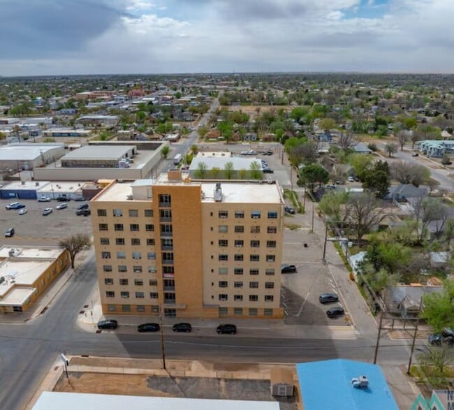

Property Detail
200 W 1St St
R001718
SUBD: THURBERS BLOCK: 2 LOT: 1 THRU:- LOT: 3 , , S: 5 T: 11S R: 24E DOC# 202403934 WD (REC)
Realpropertynec
CHAVES
CENTRAL BU
New Mexico
C and X Area of minimal flood hazard, usually depicted on FIRMs as above the 500-year flood level.
1,3
2024
0.68 AC
2025
New Mexico South Area
000201
Other Market Areas
69,984 SF
Roswell, NM
NEARBY LISTINGS FOR SALE OR LEASE
DEMOGRAPHICS near 200 W 1St St
1 mile
3 mile
5 mile
2024 Total Population
9,200
42,002
50,657
2029 Population
9,248
41,632
50,173
Pop Growth 2024-2029
+ 0.52%
(0.88%)
(0.96%)
Average Age
37
38
38
2024 Total Households
3,431
15,801
18,948
HH Growth 2024-2029
+ 0.35%
(0.98%)
(1.05%)
Median Household Inc
$34,366
$48,983
$51,622
Avg Household Size
2.50
2.60
2.60
2024 Avg HH Vehicles
2.00
2.00
2.00
Median Home Value
$104,694
$154,074
$163,116
Median Year Built
1957
1967
1969
Nearby Places
Map Layers
Map Styles
 Street
 Aerial
Transit
 Traffic
 Biking
Places
Listings with unknown addresses are not visible on the map
- Restaurants
- Banks
- Shops
- Fitness
- Groceries
PUBLIC TRANSPORTATION
AIRPORT
Roswell Air Center
Drive
Walk
Distance
Roswell Air Center
14 min
6.7 mi
Freight Ports
Tulsa Port Of Catoosa
Drive
Walk
Distance
Tulsa Port Of Catoosa
642 min
589.3 mi
SALE & LEASE HISTORY
LISTING DATE
SALE/LEASE

May 07, 2025
For Sale
Nearby Properties
Address
Land Use
TOTAL SIZE
Lot Size
Zoning
Address
Land Use
TOTAL SIZE
Lot Size
Zoning
1,829,640 SF
3.68 AC
CENTRAL BU
Address
Land Use
TOTAL SIZE
Lot Size
Zoning
10,644 SF
5.81 AC
COMMUNITY
Address
Land Use
TOTAL SIZE
Lot Size
Zoning
42.76 AC
RESIDENTIA
Address
Land Use
TOTAL SIZE
Lot Size
Zoning
16.12 AC
LIGHT INDU
Address
Land Use
TOTAL SIZE
Lot Size
Zoning
23.93 AC
RESIDENTIA
Address
Land Use
TOTAL SIZE
Lot Size
Zoning
18.18 AC
COMMUNITY
Address
Land Use
TOTAL SIZE
Lot Size
Zoning
230,872 SF
9.40 AC
COMMUNITY
Address
Land Use
TOTAL SIZE
Lot Size
Zoning
10 AC
RESIDENTIA
Address
Land Use
TOTAL SIZE
Lot Size
Zoning
2.54 AC
RESIDENTIA
Address
Land Use
TOTAL SIZE
Lot Size
Zoning
2.58 AC
COMMUNITY
Address
Land Use
TOTAL SIZE
Lot Size
Zoning
150.96 AC
RESIDENTIA
Address
Land Use
TOTAL SIZE
Lot Size
Zoning
1.59 AC
CENTRAL BU
Address
Land Use
TOTAL SIZE
Lot Size
Zoning
56.23 AC
Address
Land Use
TOTAL SIZE
Lot Size
Zoning
11.02 AC
RESIDENTIA
Address
Land Use
TOTAL SIZE
Lot Size
Zoning
18,630 SF
9.10 AC
COMMUNITY
Address
Land Use
TOTAL SIZE
Lot Size
Zoning
12,000 SF
1.28 AC
COMMUNITY
Address
Land Use
TOTAL SIZE
Lot Size
Zoning
17,567 SF
1.24 AC
RESIDENTIA
Address
Land Use
TOTAL SIZE
Lot Size
Zoning
6.47 AC
RESIDENTIA
Address
Land Use
TOTAL SIZE
Lot Size
Zoning
2.36 AC
RESIDENTIA
Address
Land Use
TOTAL SIZE
Lot Size
Zoning
9.52 AC
RESIDENTIA
Address
Land Use
TOTAL SIZE
Lot Size
Zoning
3.58 AC
RESIDENTIA
Address
Land Use
TOTAL SIZE
Lot Size
Zoning
2.10 AC
CENTRAL BU
Address
Land Use
TOTAL SIZE
Lot Size
Zoning
5 AC
RESIDENTIA
Address
Land Use
TOTAL SIZE
Lot Size
Zoning
Address
Land Use
TOTAL SIZE
Lot Size
Zoning
4.91 AC
RESIDENTIA
Address
Land Use
TOTAL SIZE
Lot Size
Zoning
38,671 SF
6.59 AC
COMMUNITY
Address
Land Use
TOTAL SIZE
Lot Size
Zoning
21,500 SF
4.78 AC
COMMUNITY
Address
Land Use
TOTAL SIZE
Lot Size
Zoning
2.61 AC
RESIDENTIA
Address
Land Use
TOTAL SIZE
Lot Size
Zoning
44,153 SF
1.29 AC
CENTRAL BU
Address
Land Use
TOTAL SIZE
Lot Size
Zoning
20.23 AC
RESIDENTIA
The World's #1 Commercial Real Estate Marketplace
Connect with us
© 2026 CoStar Group
The information above has been obtained from sources believed reliable. While we do not doubt its accuracy we have not verified it and make no guarantee, warranty or representation about it. It is your responsibility to independently confirm its accuracy and completeness. Any projections, opinions, assumptions, or estimates used are for example only and do not represent the current or future performance of the property. The value of this transaction to you depends on tax and other factors which should be evaluated by your tax, financial, and legal advisors. You and your advisors should conduct a careful, independent investigation of the property to determine to your satisfaction the suitability of the property for your needs.