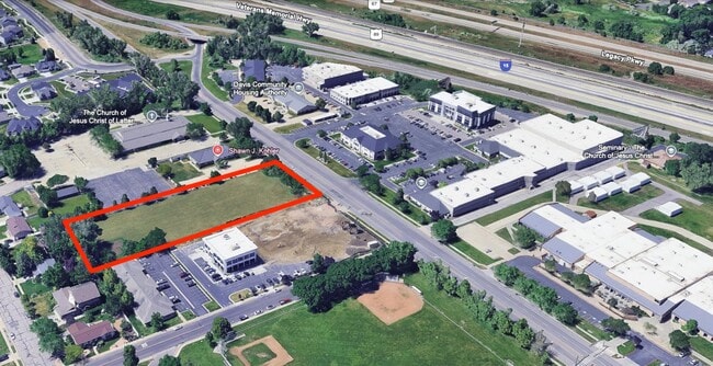
Property Record
200 W 250 S, Kaysville, UT 84037

This Property Is For Sale
NEARBY LISTINGS FOR SALE OR LEASE
-
-
View all Kaysville listings for sale on LoopNet.com
Property Detail
200 W 250 S
Ogden-Clearfield, UT
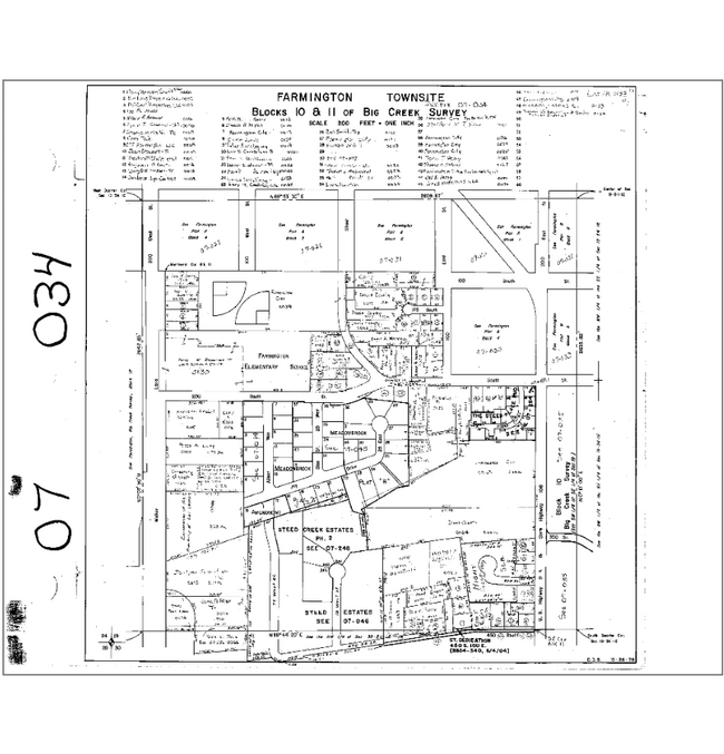
BEG AT A PT WH IS N 89^31'33" W 480.00 FT & S 0^21'44" E 226.88 FT FR THE NW COR OF LOT 1, MEADOWBROOK SUB PLAT A, A SUB OF PART OF SEC 19-T3N-R1E, SLM, SD POB IS ALSO GIVEN AS S 0^21'44" E 1025.88 FT
07-034-0100
Davis
Miscellaneous
Utah
X
1
49011C0382F
1.79 AC
2025
Davis/Weber Counties
2025
Salt Lake City
127100
DEMOGRAPHICS near 200 W 250 S
1 Mile
3 Mile
5 Mile
2024 Total Population
7,031
34,195
75,008
2029 Population
7,589
37,098
81,345
Pop Growth 2024-2029
+ 7.94%
+ 8.49%
+ 8.45%
Average Age
36
35
36
2024 Total Households
2,084
9,868
22,417
HH Growth 2024-2029
+ 8.21%
+ 8.84%
+ 8.72%
Median Household Inc
$117,329
$129,227
$122,486
Avg Household Size
3.30
3.40
3.30
2024 Avg HH Vehicles
2.00
2.00
2.00
Median Home Value
$728,960
$727,123
$692,079
Median Year Built
1990
2001
1994
Nearby Places
Map Layers
Map Styles
 Street
 Aerial
- Restaurants
- Banks
- Shops
- Fitness
- Groceries
PUBLIC TRANSPORTATION
COMMUTER RAIL
Farmington (FrontRunner North - Utah Transit Authority (UTA))
DRIVE
WALK
Distance
Farmington (FrontRunner North - Utah Transit Authority (UTA))
4 min
2.1 mi
Woods Cross (FrontRunner North - Utah Transit Authority (UTA))
DRIVE
WALK
Distance
Woods Cross (FrontRunner North - Utah Transit Authority (UTA))
10 min
7.0 mi
AIRPORT
Salt Lake City International
DRIVE
WALK
Distance
Salt Lake City International
25 min
19.2 mi
Freight Ports
Port of Stockton
DRIVE
WALK
Distance
Port of Stockton
725 min
709.6 mi
Nearby Properties
Address
Land Use
TOTAL SIZE
Lot Size
Zoning
Address
Land Use
TOTAL SIZE
Lot Size
Zoning
371,611 SF
1.38 AC
BP
Address
Land Use
TOTAL SIZE
Lot Size
Zoning
311,349 SF
22.14 AC
BP
Address
Land Use
TOTAL SIZE
Lot Size
Zoning
198,936 SF
8.85 AC
TMU
Address
Land Use
TOTAL SIZE
Lot Size
Zoning
252,789 SF
4.56 AC
Address
Land Use
TOTAL SIZE
Lot Size
Zoning
8,538 SF
71.92 AC
CR
Address
Land Use
TOTAL SIZE
Lot Size
Zoning
5,173 SF
13.16 AC
Address
Land Use
TOTAL SIZE
Lot Size
Zoning
71,398 SF
6.38 AC
TMU
Address
Land Use
TOTAL SIZE
Lot Size
Zoning
79,159 SF
6.33 AC
Address
Land Use
TOTAL SIZE
Lot Size
Zoning
116,632 SF
25.93 AC
TMU
Address
Land Use
TOTAL SIZE
Lot Size
Zoning
136,666 SF
13.69 AC
Address
Land Use
TOTAL SIZE
Lot Size
Zoning
92,038 SF
0.62 AC
BR
Address
Land Use
TOTAL SIZE
Lot Size
Zoning
111,724 SF
10.54 AC
AE
Address
Land Use
TOTAL SIZE
Lot Size
Zoning
101,016 SF
4.83 AC
BP
Address
Land Use
TOTAL SIZE
Lot Size
Zoning
314,943 SF
3.47 AC
TMU
Address
Land Use
TOTAL SIZE
Lot Size
Zoning
22,071 SF
4.39 AC
TMU
Address
Land Use
TOTAL SIZE
Lot Size
Zoning
54,137 SF
5.36 AC
TMU
Address
Land Use
TOTAL SIZE
Lot Size
Zoning
47,666 SF
9.41 AC
Address
Land Use
TOTAL SIZE
Lot Size
Zoning
73,158 SF
12.49 AC
AE
Address
Land Use
TOTAL SIZE
Lot Size
Zoning
34,429 SF
3.51 AC
Address
Land Use
TOTAL SIZE
Lot Size
Zoning
62,912 SF
11.71 AC
CMU
Address
Land Use
TOTAL SIZE
Lot Size
Zoning
5,000 SF
48.64 AC
A
Address
Land Use
TOTAL SIZE
Lot Size
Zoning
49,447 SF
1.83 AC
OTRF
Address
Land Use
TOTAL SIZE
Lot Size
Zoning
127,480 SF
4.34 AC
A
Address
Land Use
TOTAL SIZE
Lot Size
Zoning
67,980 SF
6.34 AC
TMU
Address
Land Use
TOTAL SIZE
Lot Size
Zoning
69,423 SF
3.92 AC
Address
Land Use
TOTAL SIZE
Lot Size
Zoning
68,982 SF
8.91 AC
Address
Land Use
TOTAL SIZE
Lot Size
Zoning
31,830 SF
16.08 AC
C-R
Address
Land Use
TOTAL SIZE
Lot Size
Zoning
44,679 SF
5 AC
AE
Address
Land Use
TOTAL SIZE
Lot Size
Zoning
22,626 SF
5.20 AC
Address
Land Use
TOTAL SIZE
Lot Size
Zoning
17,922 SF
4 AC
BP
The World's #1 Commercial Real Estate Marketplace
Connect with us
© 2026 CoStar Group
The information above has been obtained from sources believed reliable. While we do not doubt its accuracy we have not verified it and make no guarantee, warranty or representation about it. It is your responsibility to independently confirm its accuracy and completeness. Any projections, opinions, assumptions, or estimates used are for example only and do not represent the current or future performance of the property. The value of this transaction to you depends on tax and other factors which should be evaluated by your tax, financial, and legal advisors. You and your advisors should conduct a careful, independent investigation of the property to determine to your satisfaction the suitability of the property for your needs.