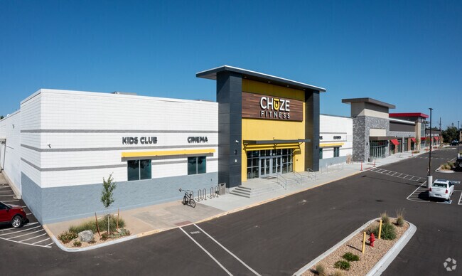
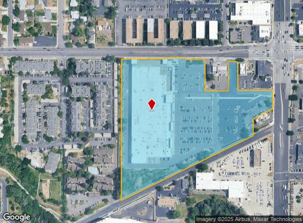
Property Record
200 W Belleview Ave, Englewood, CO 80110

NEARBY LISTINGS FOR SALE OR LEASE
Property Detail
200 W Belleview Ave
Denver-Aurora-Lakewood, CO
Sarum Englewood Investors Llc
2077-15-2-29-001
TOWNSHIP T5S MAPPLATB 549 MAPPLATP 28 SUBDIVISIONCD 054120 SUBDIVISIONNAME SARUM ENGLEWOOD INVESTORS LLC LOT 001 LOT 1 SARUM ENGLEWOOD INVESTORS LLC
Storebuilding
Arapahoe
X
Colorado
08005C0451M
1
2023
11.52 AC
2024
South
006601
Denver
146,877 SF
DEMOGRAPHICS near 200 W Belleview Ave
1 Mile
3 Mile
5 Mile
2024 Total Population
16,880
97,485
291,921
2029 Population
17,085
97,944
294,995
Pop Growth 2024-2029
+ 1.21%
+ 0.47%
+ 1.05%
Average Age
39
41
41
2024 Total Households
7,364
42,504
122,912
HH Growth 2024-2029
+ 1.39%
+ 0.53%
+ 1.23%
Median Household Inc
$64,031
$81,220
$93,312
Avg Household Size
2.20
2.20
2.30
2024 Avg HH Vehicles
2.00
2.00
2.00
Median Home Value
$474,729
$561,617
$625,319
Median Year Built
1963
1970
1975
Nearby Places
Map Layers
Map Styles
 Street
 Aerial
- Restaurants
- Banks
- Shops
- Fitness
- Groceries
PUBLIC TRANSPORTATION
AIRPORT
Denver International
DRIVE
WALK
Distance
Denver International
41 min
30.9 mi
Freight Ports
Tulsa Port Of Catoosa
DRIVE
WALK
Distance
Tulsa Port Of Catoosa
737 min
713.6 mi
SALE & LEASE HISTORY
LISTING DATE
SALE/LEASE

Dec 18, 2017
For Lease
Nearby Properties
Address
Land Use
TOTAL SIZE
Lot Size
Zoning
Address
Land Use
TOTAL SIZE
Lot Size
Zoning
248,291 SF
128.77 AC
CMP-H2
Address
Land Use
TOTAL SIZE
Lot Size
Zoning
330,776 SF
48.11 AC
CMP-H2
Address
Land Use
TOTAL SIZE
Lot Size
Zoning
214,192 SF
0.03 AC
Address
Land Use
TOTAL SIZE
Lot Size
Zoning
251,583 SF
38.03 AC
Address
Land Use
TOTAL SIZE
Lot Size
Zoning
33,500 SF
53.33 AC
Address
Land Use
TOTAL SIZE
Lot Size
Zoning
167,287 SF
13.65 AC
Address
Land Use
TOTAL SIZE
Lot Size
Zoning
458,000 SF
5.85 AC
Address
Land Use
TOTAL SIZE
Lot Size
Zoning
139,858 SF
2.36 AC
Address
Land Use
TOTAL SIZE
Lot Size
Zoning
572,657 SF
0.21 AC
LPD-C
Address
Land Use
TOTAL SIZE
Lot Size
Zoning
221,025 SF
8.45 AC
PUD
Address
Land Use
TOTAL SIZE
Lot Size
Zoning
118,881 SF
107.83 AC
Address
Land Use
TOTAL SIZE
Lot Size
Zoning
107,159 SF
26.40 AC
Address
Land Use
TOTAL SIZE
Lot Size
Zoning
47.24 AC
Address
Land Use
TOTAL SIZE
Lot Size
Zoning
7,035 SF
12.90 AC
LPD-R
Address
Land Use
TOTAL SIZE
Lot Size
Zoning
110,016 SF
1.29 AC
Address
Land Use
TOTAL SIZE
Lot Size
Zoning
250,402 SF
21 AC
Address
Land Use
TOTAL SIZE
Lot Size
Zoning
229,830 SF
11.33 AC
Address
Land Use
TOTAL SIZE
Lot Size
Zoning
206,632 SF
33.68 AC
Address
Land Use
TOTAL SIZE
Lot Size
Zoning
299,772 SF
14.19 AC
Address
Land Use
TOTAL SIZE
Lot Size
Zoning
39.44 AC
Address
Land Use
TOTAL SIZE
Lot Size
Zoning
157,145 SF
15.70 AC
Address
Land Use
TOTAL SIZE
Lot Size
Zoning
133,594 SF
25.03 AC
Address
Land Use
TOTAL SIZE
Lot Size
Zoning
146,156 SF
4.61 AC
Address
Land Use
TOTAL SIZE
Lot Size
Zoning
227,359 SF
11.31 AC
Address
Land Use
TOTAL SIZE
Lot Size
Zoning
248,058 SF
12.24 AC
Address
Land Use
TOTAL SIZE
Lot Size
Zoning
677,688 SF
2.97 AC
Address
Land Use
TOTAL SIZE
Lot Size
Zoning
280,912 SF
10.98 AC
Address
Land Use
TOTAL SIZE
Lot Size
Zoning
205,534 SF
10.12 AC
Address
Land Use
TOTAL SIZE
Lot Size
Zoning
2.67 AC
EB2
The World's #1 Commercial Real Estate Marketplace
Connect with us
© 2025 CoStar Group
The information above has been obtained from sources believed reliable. While we do not doubt its accuracy we have not verified it and make no guarantee, warranty or representation about it. It is your responsibility to independently confirm its accuracy and completeness. Any projections, opinions, assumptions, or estimates used are for example only and do not represent the current or future performance of the property. The value of this transaction to you depends on tax and other factors which should be evaluated by your tax, financial, and legal advisors. You and your advisors should conduct a careful, independent investigation of the property to determine to your satisfaction the suitability of the property for your needs.