Property Record
200 W Green St, Rockingham, NC 28379


NEARBY LISTINGS FOR SALE OR LEASE
-
-
View all Rockingham listings for sale on LoopNet.com
Property Detail
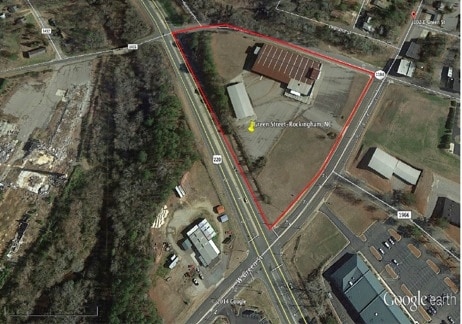
200 W Green St
746315742326
As Delineated On That Plat
Realpropertynec
LT & DOLLAR GENERAL
X
Richmond
3710746300J
North Carolina
2025
1.26 AC
2025
North Carolina Southeast Area
970500
Other Market Areas
9,301 SF
Rockingham, NC
DEMOGRAPHICS near 200 W Green St
1 Mile
3 Mile
5 Mile
2024 Total Population
2,969
16,357
24,571
2029 Population
2,980
16,245
24,374
Pop Growth 2024-2029
+ 0.37%
(0.68%)
(0.80%)
Average Age
40
40
41
2024 Total Households
1,192
6,740
10,064
HH Growth 2024-2029
+ 0.50%
(0.65%)
(0.78%)
Median Household Inc
$30,814
$34,441
$36,754
Avg Household Size
2.30
2.30
2.40
2024 Avg HH Vehicles
2.00
2.00
2.00
Median Home Value
$107,843
$94,211
$99,318
Median Year Built
1965
1971
1975
Nearby Places
Map Layers
Map Styles
 Street
 Aerial
- Restaurants
- Banks
- Shops
- Fitness
- Groceries
PUBLIC TRANSPORTATION
COMMUTER RAIL
Hamlet Amtrak Station (Silver Star - Amtrak)
DRIVE
WALK
Distance
Hamlet Amtrak Station (Silver Star - Amtrak)
11 min
6.5 mi
Freight Ports
Port of Wilmington
DRIVE
WALK
Distance
Port of Wilmington
159 min
129.2 mi
SALE & LEASE HISTORY
LISTING DATE
SALE/LEASE

Sep 24, 2016
For Sale
Nearby Properties
Address
Land Use
TOTAL SIZE
Lot Size
Zoning
Address
Land Use
TOTAL SIZE
Lot Size
Zoning
187,379 SF
43.43 AC
Address
Land Use
TOTAL SIZE
Lot Size
Zoning
131,657 SF
18.83 AC
Address
Land Use
TOTAL SIZE
Lot Size
Zoning
5,120 SF
15.36 AC
Address
Land Use
TOTAL SIZE
Lot Size
Zoning
66,923 SF
26.15 AC
Address
Land Use
TOTAL SIZE
Lot Size
Zoning
25,854 SF
12.76 AC
I2
Address
Land Use
TOTAL SIZE
Lot Size
Zoning
20,240 SF
2.85 AC
Address
Land Use
TOTAL SIZE
Lot Size
Zoning
13,057 SF
1.78 AC
Address
Land Use
TOTAL SIZE
Lot Size
Zoning
156,574 SF
27.74 AC
B3
Address
Land Use
TOTAL SIZE
Lot Size
Zoning
20,280 SF
5.49 AC
Address
Land Use
TOTAL SIZE
Lot Size
Zoning
74,881 SF
11.40 AC
Address
Land Use
TOTAL SIZE
Lot Size
Zoning
32,284 SF
7.82 AC
B3
Address
Land Use
TOTAL SIZE
Lot Size
Zoning
42,140 SF
5.69 AC
Address
Land Use
TOTAL SIZE
Lot Size
Zoning
17,086 SF
4.92 AC
Address
Land Use
TOTAL SIZE
Lot Size
Zoning
15,903 SF
1.25 AC
Address
Land Use
TOTAL SIZE
Lot Size
Zoning
5.03 AC
B3
Address
Land Use
TOTAL SIZE
Lot Size
Zoning
361,307 SF
122.08 AC
Address
Land Use
TOTAL SIZE
Lot Size
Zoning
30,360 SF
21.22 AC
Address
Land Use
TOTAL SIZE
Lot Size
Zoning
4,810 SF
9 AC
Address
Land Use
TOTAL SIZE
Lot Size
Zoning
62,360 SF
10.16 AC
Address
Land Use
TOTAL SIZE
Lot Size
Zoning
11,572 SF
1.67 AC
Address
Land Use
TOTAL SIZE
Lot Size
Zoning
40,000 SF
9.32 AC
Address
Land Use
TOTAL SIZE
Lot Size
Zoning
13,200 SF
7.59 AC
Address
Land Use
TOTAL SIZE
Lot Size
Zoning
17,061 SF
3.13 AC
R12
Address
Land Use
TOTAL SIZE
Lot Size
Zoning
7,566 SF
9.40 AC
Address
Land Use
TOTAL SIZE
Lot Size
Zoning
15,000 SF
2.49 AC
B3
Address
Land Use
TOTAL SIZE
Lot Size
Zoning
7,325 SF
1.78 AC
Address
Land Use
TOTAL SIZE
Lot Size
Zoning
40,000 SF
20.44 AC
Address
Land Use
TOTAL SIZE
Lot Size
Zoning
10.11 AC
Address
Land Use
TOTAL SIZE
Lot Size
Zoning
34,529 SF
4.15 AC
R9
Address
Land Use
TOTAL SIZE
Lot Size
Zoning
4,800 SF
10 AC
The World's #1 Commercial Real Estate Marketplace
Connect with us
© 2026 CoStar Group
The information above has been obtained from sources believed reliable. While we do not doubt its accuracy we have not verified it and make no guarantee, warranty or representation about it. It is your responsibility to independently confirm its accuracy and completeness. Any projections, opinions, assumptions, or estimates used are for example only and do not represent the current or future performance of the property. The value of this transaction to you depends on tax and other factors which should be evaluated by your tax, financial, and legal advisors. You and your advisors should conduct a careful, independent investigation of the property to determine to your satisfaction the suitability of the property for your needs.