Property Record
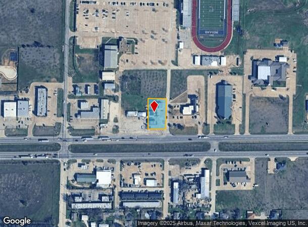
200 W Highway 67, Alvarado, TX 76009
NEARBY LISTINGS FOR SALE OR LEASE
Property Detail
200 W Highway 67
126-0737-00141
Alvarado Junior High Addition
Commercialnec
ABST 737 TR 18 PT J M ROSS 126.5523.10010,99206,99572
X
Johnson
48251C0215J
Texas
2024
0.62 AC
2025
Johnson County
130417
Dallas/Ft Worth
1,263 SF
Dallas-Fort Worth-Arlington, TX
DEMOGRAPHICS near 200 W Highway 67
1 Mile
3 Mile
5 Mile
2024 Total Population
2,660
10,041
22,633
2029 Population
3,227
12,101
27,083
Pop Growth 2024-2029
+ 21.32%
+ 20.52%
+ 19.66%
Average Age
36
36
37
2024 Total Households
872
3,230
7,178
HH Growth 2024-2029
+ 21.90%
+ 21.05%
+ 20.16%
Median Household Inc
$67,247
$80,845
$76,199
Avg Household Size
3.00
2.90
3.00
2024 Avg HH Vehicles
2.00
2.00
2.00
Median Home Value
$139,433
$169,549
$169,675
Median Year Built
1989
1993
1993
Nearby Places
Map Layers
Map Styles
 Street
 Aerial
- Restaurants
- Banks
- Shops
- Fitness
- Groceries
Nearby Properties
Address
Land Use
TOTAL SIZE
Lot Size
Zoning
Address
Land Use
TOTAL SIZE
Lot Size
Zoning
157,850 SF
85.56 AC
Address
Land Use
TOTAL SIZE
Lot Size
Zoning
209,318 SF
69.85 AC
Address
Land Use
TOTAL SIZE
Lot Size
Zoning
Address
Land Use
TOTAL SIZE
Lot Size
Zoning
234,338 SF
5.89 AC
Address
Land Use
TOTAL SIZE
Lot Size
Zoning
9.84 AC
Address
Land Use
TOTAL SIZE
Lot Size
Zoning
104,650 SF
38.63 AC
Address
Land Use
TOTAL SIZE
Lot Size
Zoning
54,000 SF
13.76 AC
Address
Land Use
TOTAL SIZE
Lot Size
Zoning
106,926 SF
16.28 AC
Address
Land Use
TOTAL SIZE
Lot Size
Zoning
63,911 SF
15 AC
Address
Land Use
TOTAL SIZE
Lot Size
Zoning
70,125 SF
19.02 AC
Address
Land Use
TOTAL SIZE
Lot Size
Zoning
60,900 SF
59.93 AC
Address
Land Use
TOTAL SIZE
Lot Size
Zoning
6,000 SF
89.84 AC
Address
Land Use
TOTAL SIZE
Lot Size
Zoning
33,000 SF
10.05 AC
Address
Land Use
TOTAL SIZE
Lot Size
Zoning
70,920 SF
9.88 AC
Address
Land Use
TOTAL SIZE
Lot Size
Zoning
31,005 SF
9.19 AC
Address
Land Use
TOTAL SIZE
Lot Size
Zoning
33.03 AC
Address
Land Use
TOTAL SIZE
Lot Size
Zoning
17,000 SF
12.49 AC
Address
Land Use
TOTAL SIZE
Lot Size
Zoning
55,300 SF
8.72 AC
Address
Land Use
TOTAL SIZE
Lot Size
Zoning
10.40 AC
Address
Land Use
TOTAL SIZE
Lot Size
Zoning
48,263 SF
10 AC
Address
Land Use
TOTAL SIZE
Lot Size
Zoning
300.17 AC
Address
Land Use
TOTAL SIZE
Lot Size
Zoning
10,510 SF
12 AC
Address
Land Use
TOTAL SIZE
Lot Size
Zoning
18.12 AC
Address
Land Use
TOTAL SIZE
Lot Size
Zoning
236.05 AC
Address
Land Use
TOTAL SIZE
Lot Size
Zoning
29,840 SF
7 AC
Address
Land Use
TOTAL SIZE
Lot Size
Zoning
41,772 SF
1.74 AC
Address
Land Use
TOTAL SIZE
Lot Size
Zoning
24,695 SF
17.88 AC
Address
Land Use
TOTAL SIZE
Lot Size
Zoning
213.12 AC
Address
Land Use
TOTAL SIZE
Lot Size
Zoning
17,863 SF
17.50 AC
Address
Land Use
TOTAL SIZE
Lot Size
Zoning
798 SF
10 AC
The World's #1 Commercial Real Estate Marketplace
Connect with us
© 2025 CoStar Group
The information above has been obtained from sources believed reliable. While we do not doubt its accuracy we have not verified it and make no guarantee, warranty or representation about it. It is your responsibility to independently confirm its accuracy and completeness. Any projections, opinions, assumptions, or estimates used are for example only and do not represent the current or future performance of the property. The value of this transaction to you depends on tax and other factors which should be evaluated by your tax, financial, and legal advisors. You and your advisors should conduct a careful, independent investigation of the property to determine to your satisfaction the suitability of the property for your needs.