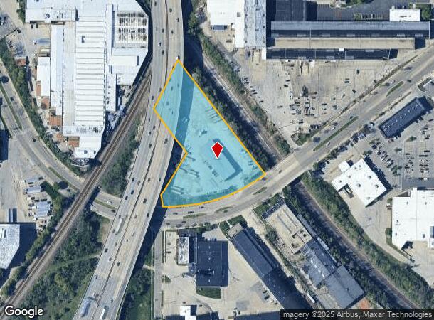
Property Record
200 W Oklahoma Ave, Milwaukee, WI 53207

NEARBY LISTINGS FOR SALE OR LEASE
Property Detail
200 W Oklahoma Ave
537-9997-100-X
LANDS IN NE 1/4 SEC 17-6-22 COM INTER NLY LI W OKLAHOMA AVE & SWLY LI C & NW RY ROW-TH NWLY ALG SD ROW 579.35'-TH SWLY ALG SELY LI C M ST P & P ROW 223.16'-TH SELY 221.05'-TH SWLY 195'-TH SLY 43.8'-TH ELY ALG NLY CRVD LI SD AVE 440.7' TO BEG SUBJECT
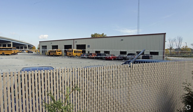
Warehouse
Milwaukee
X
Wisconsin
55079C0156E
3 AC
2024
Milwaukee SE
2024
Milwaukee/Madison
018500
Milwaukee-Waukesha-West Allis, WI
9,720 SF
DEMOGRAPHICS near 200 W Oklahoma Ave
1 Mile
3 Mile
5 Mile
2024 Total Population
22,665
153,834
336,902
2029 Population
22,040
149,976
329,416
Pop Growth 2024-2029
(2.76%)
(2.51%)
(2.22%)
Average Age
36
36
37
2024 Total Households
8,686
59,252
145,027
HH Growth 2024-2029
(2.89%)
(2.54%)
(2.14%)
Median Household Inc
$61,407
$50,904
$53,481
Avg Household Size
2.50
2.50
2.20
2024 Avg HH Vehicles
2.00
2.00
1.00
Median Home Value
$172,079
$170,097
$182,667
Median Year Built
1946
1948
1953
Nearby Places
Map Layers
Map Styles
 Street
 Aerial
- Restaurants
- Banks
- Shops
- Fitness
- Groceries
PUBLIC TRANSPORTATION
COMMUTER RAIL
DRIVE
WALK
Distance
10 min
3.6 mi
DRIVE
WALK
Distance
9 min
4.8 mi
AIRPORT
General Mitchell International
DRIVE
WALK
Distance
General Mitchell International
9 min
3.4 mi
Freight Ports
Port Milwaukee
DRIVE
WALK
Distance
Port Milwaukee
5 min
1.6 mi
Nearby Properties
Address
Land Use
TOTAL SIZE
Lot Size
Zoning
Address
Land Use
TOTAL SIZE
Lot Size
Zoning
41.05 AC
IO2
Address
Land Use
TOTAL SIZE
Lot Size
Zoning
173,610 SF
1.70 AC
IM
Address
Land Use
TOTAL SIZE
Lot Size
Zoning
319,559 SF
6.29 AC
PD
Address
Land Use
TOTAL SIZE
Lot Size
Zoning
179 AC
IH
Address
Land Use
TOTAL SIZE
Lot Size
Zoning
204,809 SF
1.04 AC
IM
Address
Land Use
TOTAL SIZE
Lot Size
Zoning
245,485 SF
6.30 AC
IM
Address
Land Use
TOTAL SIZE
Lot Size
Zoning
12.02 AC
IO2
Address
Land Use
TOTAL SIZE
Lot Size
Zoning
48.34 AC
IO1
Address
Land Use
TOTAL SIZE
Lot Size
Zoning
110,000 SF
7.59 AC
TL
Address
Land Use
TOTAL SIZE
Lot Size
Zoning
2,610 SF
1.04 AC
IM
Address
Land Use
TOTAL SIZE
Lot Size
Zoning
86.13 AC
IH
Address
Land Use
TOTAL SIZE
Lot Size
Zoning
11.38 AC
TL
Address
Land Use
TOTAL SIZE
Lot Size
Zoning
120,000 SF
1.10 AC
IM
Address
Land Use
TOTAL SIZE
Lot Size
Zoning
222,100 SF
1.29 AC
PD
Address
Land Use
TOTAL SIZE
Lot Size
Zoning
197,354 SF
18 AC
CS
Address
Land Use
TOTAL SIZE
Lot Size
Zoning
0.43 AC
RT3
Address
Land Use
TOTAL SIZE
Lot Size
Zoning
183,291 SF
11.48 AC
IM
Address
Land Use
TOTAL SIZE
Lot Size
Zoning
95,788 SF
1.04 AC
IM
Address
Land Use
TOTAL SIZE
Lot Size
Zoning
Address
Land Use
TOTAL SIZE
Lot Size
Zoning
188,328 SF
22.41 AC
PD
Address
Land Use
TOTAL SIZE
Lot Size
Zoning
17.47 AC
R2
Address
Land Use
TOTAL SIZE
Lot Size
Zoning
39.81 AC
Address
Land Use
TOTAL SIZE
Lot Size
Zoning
122,602 SF
0.89 AC
IM
Address
Land Use
TOTAL SIZE
Lot Size
Zoning
216,289 SF
1.06 AC
IM
Address
Land Use
TOTAL SIZE
Lot Size
Zoning
238,201 SF
17.96 AC
PUDR5
Address
Land Use
TOTAL SIZE
Lot Size
Zoning
162,138 SF
9.15 AC
PD
Address
Land Use
TOTAL SIZE
Lot Size
Zoning
132,289 SF
5.34 AC
PD
Address
Land Use
TOTAL SIZE
Lot Size
Zoning
83,827 SF
2.07 AC
PD
Address
Land Use
TOTAL SIZE
Lot Size
Zoning
76.97 AC
IH
Address
Land Use
TOTAL SIZE
Lot Size
Zoning
360,000 SF
14.60 AC
IL1
The World's #1 Commercial Real Estate Marketplace
Connect with us
© 2025 CoStar Group
The information above has been obtained from sources believed reliable. While we do not doubt its accuracy we have not verified it and make no guarantee, warranty or representation about it. It is your responsibility to independently confirm its accuracy and completeness. Any projections, opinions, assumptions, or estimates used are for example only and do not represent the current or future performance of the property. The value of this transaction to you depends on tax and other factors which should be evaluated by your tax, financial, and legal advisors. You and your advisors should conduct a careful, independent investigation of the property to determine to your satisfaction the suitability of the property for your needs.