Property Record
200 W Paramount St, Azusa, CA 91702


Save to a Folder
{{folder.Name}}
{{folder.ListingIds.length}} Properties
{{folder.ListingIds.length}} Property
Create a New Folder
Property Detail
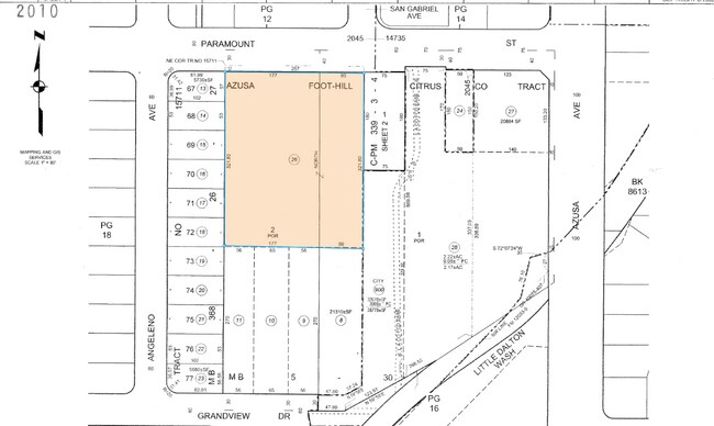
200 W Paramount St
8614-015-026
AZUSA FOOT-HILL CITRUS COMPANY TRACT 1.78 MORE OR LESS ACS COM AT NE COR OF LOT 67 TR NO 15711 TH E ON S LINE OF PARAMOUNT AVE 257 FT WITH A UNIFORM DEPTH OF 321.8 FT S PART OF LOTS 1 AND LOT 2
Hospitalpublic
Los Angeles
AZR1C*
California
B and X Area of moderate flood hazard, usually the area between the limits of the 100-year and 500-year floods.
67
2025
1.89 AC
2025
Eastern SGV
404301
Los Angeles
24,331 SF
Los Angeles-Long Beach-Glendale, CA
NEARBY LISTINGS FOR SALE OR LEASE
-
-
View all Azusa listings for sale on LoopNet.com
DEMOGRAPHICS near 200 W Paramount St
1 mile
3 mile
5 mile
2025 Total Population
28,463
163,821
358,496
2030 Population
28,032
162,242
354,514
Pop Growth 2025-2030
(1.51%)
(0.96%)
(1.11%)
Average Age
38
40
41
2025 Total Households
7,492
49,584
108,075
HH Growth 2025-2030
(1.67%)
(1.17%)
(1.28%)
Median Household Inc
$85,849
$92,452
$95,462
Avg Household Size
3.70
3.20
3.20
2025 Avg HH Vehicles
2.00
2.00
2.00
Median Home Value
$684,710
$716,203
$741,182
Median Year Built
1958
1961
1962
Nearby Places
Map Layers
Map Styles
 Street
 Aerial
Layers
 Traffic
 Biking
Places
Listings with unknown addresses are not visible on the map
- Restaurants
- Banks
- Shops
- Fitness
- Groceries
PUBLIC TRANSPORTATION
COMMUTER RAIL
Covina Metrolink Station (Metrolink San Bernardino Line - Metrolink Trains)
Drive
Walk
Distance
Covina Metrolink Station (Metrolink San Bernardino Line - Metrolink Trains)
5 min
3.0 mi
Baldwin Park Metrolink Station (Metrolink San Bernardino Line - Metrolink Trains)
Drive
Walk
Distance
Baldwin Park Metrolink Station (Metrolink San Bernardino Line - Metrolink Trains)
9 min
5.2 mi
AIRPORT
Ontario International
Drive
Walk
Distance
Ontario International
29 min
22.4 mi
Bob Hope
Drive
Walk
Distance
Bob Hope
40 min
31.4 mi
Long Beach (Daugherty Field)
Drive
Walk
Distance
Long Beach (Daugherty Field)
42 min
32.7 mi
Freight Ports
Port of Long Beach
Drive
Walk
Distance
Port of Long Beach
48 min
38.4 mi
SALE & LEASE HISTORY
LISTING DATE
SALE/LEASE

May 18, 2022
For Sale
Nearby Properties
Address
Land Use
TOTAL SIZE
Lot Size
Zoning
Address
Land Use
TOTAL SIZE
Lot Size
Zoning
836,910 SF
75.03 AC
IRM25*
Address
Land Use
TOTAL SIZE
Lot Size
Zoning
533,650 SF
5.27 AC
GDCM
Address
Land Use
TOTAL SIZE
Lot Size
Zoning
1,104,998 SF
28 AC
IRM2*
Address
Land Use
TOTAL SIZE
Lot Size
Zoning
250,688 SF
13.90 AC
LCRA8000*
Address
Land Use
TOTAL SIZE
Lot Size
Zoning
221,911 SF
2.24 AC
AZCBD*
Address
Land Use
TOTAL SIZE
Lot Size
Zoning
184,820 SF
IRM1*
Address
Land Use
TOTAL SIZE
Lot Size
Zoning
862,213 SF
21.22 AC
WCSP
Address
Land Use
TOTAL SIZE
Lot Size
Zoning
627,908 SF
23.08 AC
IRM1*
Address
Land Use
TOTAL SIZE
Lot Size
Zoning
270,111 SF
12.79 AC
IRM2*
Address
Land Use
TOTAL SIZE
Lot Size
Zoning
200,000 SF
11.41 AC
AZM2*
Address
Land Use
TOTAL SIZE
Lot Size
Zoning
822,602 SF
20.93 AC
AZM1
Address
Land Use
TOTAL SIZE
Lot Size
Zoning
160,000 SF
6.74 AC
AZM2*
Address
Land Use
TOTAL SIZE
Lot Size
Zoning
110,640 SF
2.94 AC
GDMS
Address
Land Use
TOTAL SIZE
Lot Size
Zoning
63,919 SF
2.97 AC
CVCP*
Address
Land Use
TOTAL SIZE
Lot Size
Zoning
294,391 SF
16.90 AC
WCC5*
Address
Land Use
TOTAL SIZE
Lot Size
Zoning
73,908 SF
7.70 AC
IRM1*
Address
Land Use
TOTAL SIZE
Lot Size
Zoning
145,468 SF
21.59 AC
AZC2*
Address
Land Use
TOTAL SIZE
Lot Size
Zoning
108,544 SF
6.24 AC
LCC4*
Address
Land Use
TOTAL SIZE
Lot Size
Zoning
717,472 SF
16.11 AC
AZC3*
Address
Land Use
TOTAL SIZE
Lot Size
Zoning
104,253 SF
2.88 AC
CVRD2000*
Address
Land Use
TOTAL SIZE
Lot Size
Zoning
120,588 SF
4.50 AC
WCR3-MF20*
Address
Land Use
TOTAL SIZE
Lot Size
Zoning
184,800 SF
4.73 AC
CVTCP*
Address
Land Use
TOTAL SIZE
Lot Size
Zoning
155,884 SF
7.50 AC
AZA171/2
Address
Land Use
TOTAL SIZE
Lot Size
Zoning
213,749 SF
4.99 AC
IRM2
Address
Land Use
TOTAL SIZE
Lot Size
Zoning
329,324 SF
21.84 AC
AZM2
Address
Land Use
TOTAL SIZE
Lot Size
Zoning
66,831 SF
6.01 AC
GDC_RT66SP
Address
Land Use
TOTAL SIZE
Lot Size
Zoning
155,907 SF
4.38 AC
CVR3-RD150
Address
Land Use
TOTAL SIZE
Lot Size
Zoning
163,472 SF
8.40 AC
WCR3-MF20*
The World's #1 Commercial Real Estate Marketplace
Connect with us
© 2026 CoStar Group
The information above has been obtained from sources believed reliable. While we do not doubt its accuracy we have not verified it and make no guarantee, warranty or representation about it. It is your responsibility to independently confirm its accuracy and completeness. Any projections, opinions, assumptions, or estimates used are for example only and do not represent the current or future performance of the property. The value of this transaction to you depends on tax and other factors which should be evaluated by your tax, financial, and legal advisors. You and your advisors should conduct a careful, independent investigation of the property to determine to your satisfaction the suitability of the property for your needs.