Property Record
200 Waring Rd, Syracuse, NY 13224
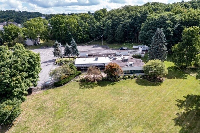
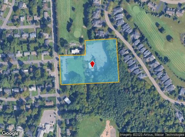

This Property Is For Sale
NEARBY LISTINGS FOR SALE OR LEASE
Property Detail
200 Waring Rd
312689-071-004-0001-004-000-0000
Onondaga
Restaurantbuilding
New York
X
4.000
36067C0238F
4.43 AC
2025
SE Outer Onondaga County
2024
Syracuse
014700
Syracuse, NY
7,024 SF
DEMOGRAPHICS near 200 Waring Rd
1 Mile
3 Mile
5 Mile
2024 Total Population
5,767
90,407
195,998
2029 Population
5,640
88,851
191,735
Pop Growth 2024-2029
(2.20%)
(1.72%)
(2.18%)
Average Age
40
37
38
2024 Total Households
1,930
33,900
79,339
HH Growth 2024-2029
(2.80%)
(1.75%)
(2.23%)
Median Household Inc
$98,704
$46,658
$49,297
Avg Household Size
2.30
2.20
2.20
2024 Avg HH Vehicles
2.00
1.00
1.00
Median Home Value
$266,326
$165,775
$151,721
Median Year Built
1968
1955
1953
Nearby Places
- Restaurants
- Banks
- Shops
- Fitness
- Groceries
PUBLIC TRANSPORTATION
COMMUTER RAIL
DRIVE
WALK
Distance
14 min
6.3 mi
DRIVE
WALK
Distance
14 min
6.3 mi
AIRPORT
Syracuse Hancock International
DRIVE
WALK
Distance
Syracuse Hancock International
20 min
11.0 mi
Nearby Properties
Address
Land Use
TOTAL SIZE
Lot Size
Zoning
Address
Land Use
TOTAL SIZE
Lot Size
Zoning
70,284 SF
74.57 AC
25
Address
Land Use
TOTAL SIZE
Lot Size
Zoning
459,040 SF
4.71 AC
06 - INDUS
Address
Land Use
TOTAL SIZE
Lot Size
Zoning
12.08 AC
Address
Land Use
TOTAL SIZE
Lot Size
Zoning
826,528 SF
2.28 AC
06 - INDUS
Address
Land Use
TOTAL SIZE
Lot Size
Zoning
269,030 SF
11.90 AC
05 - COMME
Address
Land Use
TOTAL SIZE
Lot Size
Zoning
348,998 SF
65.59 AC
25
Address
Land Use
TOTAL SIZE
Lot Size
Zoning
72,200 SF
12.39 AC
06 - INDUS
Address
Land Use
TOTAL SIZE
Lot Size
Zoning
354,492 SF
6.90 AC
25
Address
Land Use
TOTAL SIZE
Lot Size
Zoning
72,800 SF
1.89 AC
06 - INDUS
Address
Land Use
TOTAL SIZE
Lot Size
Zoning
409,062 SF
10
Address
Land Use
TOTAL SIZE
Lot Size
Zoning
522,469 SF
1.87 AC
14
Address
Land Use
TOTAL SIZE
Lot Size
Zoning
218,051 SF
2.32 AC
25
Address
Land Use
TOTAL SIZE
Lot Size
Zoning
6,598 SF
4.09 AC
14
Address
Land Use
TOTAL SIZE
Lot Size
Zoning
38,693 SF
102.34 AC
05 - COMME
Address
Land Use
TOTAL SIZE
Lot Size
Zoning
24,360 SF
3.99 AC
10
Address
Land Use
TOTAL SIZE
Lot Size
Zoning
108,368 SF
3.36 AC
14
Address
Land Use
TOTAL SIZE
Lot Size
Zoning
414,700 SF
1.94 AC
07 - MIXED
Address
Land Use
TOTAL SIZE
Lot Size
Zoning
2,709 SF
39.74 AC
06 - INDUS
Address
Land Use
TOTAL SIZE
Lot Size
Zoning
1.67 AC
06 - INDUS
Address
Land Use
TOTAL SIZE
Lot Size
Zoning
653,177 SF
1.94 AC
13
Address
Land Use
TOTAL SIZE
Lot Size
Zoning
224,736 SF
2.48 AC
10
Address
Land Use
TOTAL SIZE
Lot Size
Zoning
165,800 SF
1.27 AC
25
Address
Land Use
TOTAL SIZE
Lot Size
Zoning
164,837 SF
0.66 AC
10
Address
Land Use
TOTAL SIZE
Lot Size
Zoning
105,004 SF
2.81 AC
25
Address
Land Use
TOTAL SIZE
Lot Size
Zoning
168,000 SF
2.18 AC
06 - INDUS
Address
Land Use
TOTAL SIZE
Lot Size
Zoning
307,860 SF
1.17 AC
25
Address
Land Use
TOTAL SIZE
Lot Size
Zoning
6,400 SF
86.36 AC
06 - INDUS
Address
Land Use
TOTAL SIZE
Lot Size
Zoning
50,472 SF
4.89 AC
10
Address
Land Use
TOTAL SIZE
Lot Size
Zoning
31,947 SF
1.23 AC
Address
Land Use
TOTAL SIZE
Lot Size
Zoning
278,208 SF
1.92 AC
25
The World's #1 Commercial Real Estate Marketplace
Connect with us
© 2025 CoStar Group
The information above has been obtained from sources believed reliable. While we do not doubt its accuracy we have not verified it and make no guarantee, warranty or representation about it. It is your responsibility to independently confirm its accuracy and completeness. Any projections, opinions, assumptions, or estimates used are for example only and do not represent the current or future performance of the property. The value of this transaction to you depends on tax and other factors which should be evaluated by your tax, financial, and legal advisors. You and your advisors should conduct a careful, independent investigation of the property to determine to your satisfaction the suitability of the property for your needs.