Property Record
200 Westerly Rd, Bellingham, WA 98226

Current Lease Availabilities
NEARBY LISTINGS FOR SALE OR LEASE
Property Detail
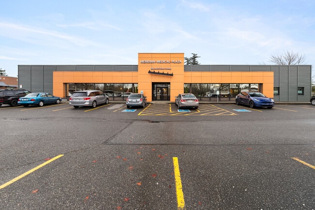
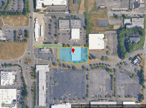
200 Westerly Rd
Bellingham, WA
Am Cordata Place Short Plat
380212-485093-0000
LOT 4 AM CORDATA PLACE SHORT PLAT AS REC BOOK 27 SHORT PLATS PG 69-EXC THAT PTN LY WITHIN FORMER LOT C CORDATA PLACE SHORT PLAT-EXC PTN TO CITY OF BELLINGHAM FOR STREET DESC AF 2041102125
Medicalbuilding
Whatcom
X
Washington
53073C1211E
4
2025
1.42 AC
2025
Bellingham/Northwest
000203
Other Market Areas
15,000 SF
DEMOGRAPHICS near 200 Westerly Rd
1 Mile
3 Mile
5 Mile
2024 Total Population
10,264
46,910
101,798
2029 Population
10,893
49,092
106,285
Pop Growth 2024-2029
+ 6.13%
+ 4.65%
+ 4.41%
Average Age
41
40
38
2024 Total Households
4,959
20,846
42,408
HH Growth 2024-2029
+ 6.27%
+ 4.74%
+ 4.62%
Median Household Inc
$50,400
$59,498
$63,368
Avg Household Size
2.00
2.20
2.20
2024 Avg HH Vehicles
1.00
2.00
2.00
Median Home Value
$382,283
$481,144
$570,249
Median Year Built
1999
1989
1987
Nearby Places
Map Layers
Map Styles
 Street
 Aerial
- Restaurants
- Banks
- Shops
- Fitness
- Groceries
PUBLIC TRANSPORTATION
AIRPORT
Bellingham International
DRIVE
WALK
Distance
Bellingham International
7 min
2.6 mi
Abbotsford International
DRIVE
WALK
Distance
Abbotsford International
43 min
24.0 mi
Vancouver International
DRIVE
WALK
Distance
Vancouver International
74 min
49.6 mi
Freight Ports
Port of Bellingham, WA
DRIVE
WALK
Distance
Port of Bellingham, WA
9 min
4.0 mi
Nearby Properties
Address
Land Use
TOTAL SIZE
Lot Size
Zoning
Address
Land Use
TOTAL SIZE
Lot Size
Zoning
507,750 SF
15.05 AC
IN
Address
Land Use
TOTAL SIZE
Lot Size
Zoning
203,749 SF
162.97 AC
CWF
Address
Land Use
TOTAL SIZE
Lot Size
Zoning
111,507 SF
845.26 AC
AO
Address
Land Use
TOTAL SIZE
Lot Size
Zoning
259,312 SF
2.76 AC
P
Address
Land Use
TOTAL SIZE
Lot Size
Zoning
330,497 SF
30.17 AC
P
Address
Land Use
TOTAL SIZE
Lot Size
Zoning
46,850 SF
129.61 AC
RMPLAN
Address
Land Use
TOTAL SIZE
Lot Size
Zoning
151,677 SF
12.84 AC
PCM
Address
Land Use
TOTAL SIZE
Lot Size
Zoning
256,155 SF
36.63 AC
PCW
Address
Land Use
TOTAL SIZE
Lot Size
Zoning
662,133 SF
118.82 AC
I
Address
Land Use
TOTAL SIZE
Lot Size
Zoning
177,740 SF
7.42 AC
PC
Address
Land Use
TOTAL SIZE
Lot Size
Zoning
239,925 SF
17.46 AC
PC
Address
Land Use
TOTAL SIZE
Lot Size
Zoning
112,423 SF
3.23 AC
RS
Address
Land Use
TOTAL SIZE
Lot Size
Zoning
89,174 SF
3.74 AC
PCLI
Address
Land Use
TOTAL SIZE
Lot Size
Zoning
201,508 SF
13.73 AC
P
Address
Land Use
TOTAL SIZE
Lot Size
Zoning
218,295 SF
13.22 AC
PRM2.5
Address
Land Use
TOTAL SIZE
Lot Size
Zoning
148,945 SF
1.51 AC
PCM
Address
Land Use
TOTAL SIZE
Lot Size
Zoning
239,299 SF
7.73 AC
PRM2.5
Address
Land Use
TOTAL SIZE
Lot Size
Zoning
104,251 SF
14.10 AC
PU
Address
Land Use
TOTAL SIZE
Lot Size
Zoning
215,766 SF
6.09 AC
PRM2.5
Address
Land Use
TOTAL SIZE
Lot Size
Zoning
459,793 SF
25.47 AC
PREC
Address
Land Use
TOTAL SIZE
Lot Size
Zoning
159,238 SF
1.54 AC
PICR
Address
Land Use
TOTAL SIZE
Lot Size
Zoning
152,381 SF
6.05 AC
PC
Address
Land Use
TOTAL SIZE
Lot Size
Zoning
84,006 SF
16.20 AC
PICR4
Address
Land Use
TOTAL SIZE
Lot Size
Zoning
95,263 SF
2.84 AC
PIN
Address
Land Use
TOTAL SIZE
Lot Size
Zoning
146,187 SF
6.44 AC
PC
Address
Land Use
TOTAL SIZE
Lot Size
Zoning
162,443 SF
8.01 AC
PI
Address
Land Use
TOTAL SIZE
Lot Size
Zoning
158,200 SF
1.34 AC
PICR
Address
Land Use
TOTAL SIZE
Lot Size
Zoning
178,131 SF
7.42 AC
URM18
Address
Land Use
TOTAL SIZE
Lot Size
Zoning
168,279 SF
2.50 AC
PCM2.5
Address
Land Use
TOTAL SIZE
Lot Size
Zoning
143,818 SF
6.75 AC
RM2.0
The World's #1 Commercial Real Estate Marketplace
Connect with us
© 2026 CoStar Group
The information above has been obtained from sources believed reliable. While we do not doubt its accuracy we have not verified it and make no guarantee, warranty or representation about it. It is your responsibility to independently confirm its accuracy and completeness. Any projections, opinions, assumptions, or estimates used are for example only and do not represent the current or future performance of the property. The value of this transaction to you depends on tax and other factors which should be evaluated by your tax, financial, and legal advisors. You and your advisors should conduct a careful, independent investigation of the property to determine to your satisfaction the suitability of the property for your needs.