Property Record
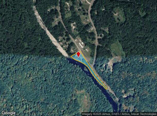
200 Worthington Rd, Huntington, MA 01050

This Property Is For Sale
NEARBY LISTINGS FOR SALE OR LEASE
-
-
View all Huntington listings for sale on LoopNet.com
Property Detail
200 Worthington Rd
Springfield, MA
Hampshire
HUNT-000326-000001-A000000
Massachusetts
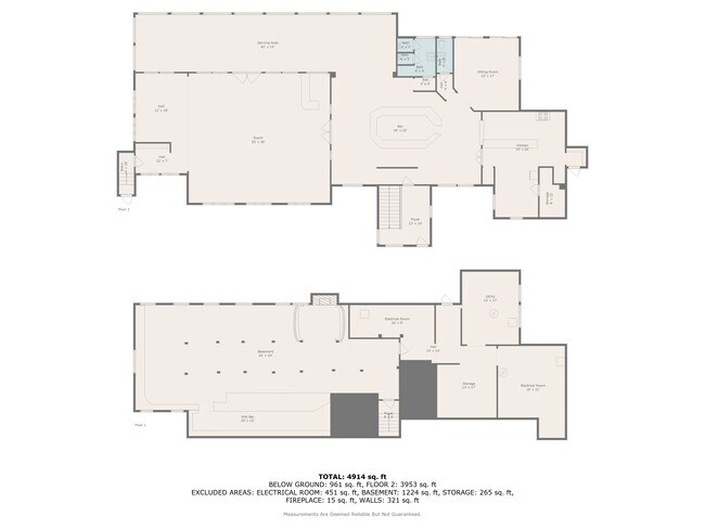
Restaurantbuilding
a
2025
1.87 AC
2025
Hampshire County
822601
Hartford
4,088 SF
DEMOGRAPHICS near 200 Worthington Rd
1 Mile
3 Mile
5 Mile
2024 Total Population
364
1,906
3,173
2029 Population
293
1,540
2,637
Pop Growth 2024-2029
(19.51%)
(19.20%)
(16.89%)
Average Age
44
44
45
2024 Total Households
146
788
1,322
HH Growth 2024-2029
(19.86%)
(19.29%)
(16.94%)
Median Household Inc
$87,500
$73,399
$77,371
Avg Household Size
2.50
2.40
2.40
2024 Avg HH Vehicles
2.00
2.00
2.00
Median Home Value
$273,404
$274,383
$298,407
Median Year Built
1960
1955
1957
Nearby Places
Map Layers
Map Styles
 Street
 Aerial
- Restaurants
- Banks
- Shops
- Fitness
- Groceries
PUBLIC TRANSPORTATION
AIRPORT
Bradley International
DRIVE
WALK
Distance
Bradley International
65 min
32.8 mi
Freight Ports
Albany, NY Port
DRIVE
WALK
Distance
Albany, NY Port
98 min
70.6 mi
Nearby Properties
Address
Land Use
TOTAL SIZE
Lot Size
Zoning
Address
Land Use
TOTAL SIZE
Lot Size
Zoning
1,152 SF
1,261 AC
Address
Land Use
TOTAL SIZE
Lot Size
Zoning
192,443 SF
39.50 AC
Address
Land Use
TOTAL SIZE
Lot Size
Zoning
912 SF
147 AC
Address
Land Use
TOTAL SIZE
Lot Size
Zoning
17,520 SF
1.20 AC
Address
Land Use
TOTAL SIZE
Lot Size
Zoning
13,645 SF
120.80 AC
R135
Address
Land Use
TOTAL SIZE
Lot Size
Zoning
1,460 AC
AR
Address
Land Use
TOTAL SIZE
Lot Size
Zoning
673 AC
Address
Land Use
TOTAL SIZE
Lot Size
Zoning
5,288 SF
66.40 AC
R45
Address
Land Use
TOTAL SIZE
Lot Size
Zoning
32.40 AC
Address
Land Use
TOTAL SIZE
Lot Size
Zoning
2,721 SF
4.60 AC
R45
Address
Land Use
TOTAL SIZE
Lot Size
Zoning
5,734 SF
138.95 AC
Address
Land Use
TOTAL SIZE
Lot Size
Zoning
2,665 SF
1.30 AC
Address
Land Use
TOTAL SIZE
Lot Size
Zoning
286.50 AC
R1
Address
Land Use
TOTAL SIZE
Lot Size
Zoning
6,536 SF
2.38 AC
Address
Land Use
TOTAL SIZE
Lot Size
Zoning
2,029 SF
3.84 AC
Address
Land Use
TOTAL SIZE
Lot Size
Zoning
3,129 SF
30.33 AC
Address
Land Use
TOTAL SIZE
Lot Size
Zoning
27.50 AC
Address
Land Use
TOTAL SIZE
Lot Size
Zoning
4,034 SF
1.50 AC
R25
Address
Land Use
TOTAL SIZE
Lot Size
Zoning
5,320 SF
1.03 AC
Address
Land Use
TOTAL SIZE
Lot Size
Zoning
2,091 SF
0.30 AC
Address
Land Use
TOTAL SIZE
Lot Size
Zoning
2,436 SF
2.30 AC
R45
Address
Land Use
TOTAL SIZE
Lot Size
Zoning
10.50 AC
AR
Address
Land Use
TOTAL SIZE
Lot Size
Zoning
32.34 AC
Address
Land Use
TOTAL SIZE
Lot Size
Zoning
806 SF
37.70 AC
Address
Land Use
TOTAL SIZE
Lot Size
Zoning
4,959 SF
6 AC
AR
Address
Land Use
TOTAL SIZE
Lot Size
Zoning
5,293 SF
0.22 AC
Address
Land Use
TOTAL SIZE
Lot Size
Zoning
5,260 SF
0.50 AC
Address
Land Use
TOTAL SIZE
Lot Size
Zoning
3,320 SF
2.31 AC
Address
Land Use
TOTAL SIZE
Lot Size
Zoning
266 AC
Address
Land Use
TOTAL SIZE
Lot Size
Zoning
2,712 SF
0.50 AC
The World's #1 Commercial Real Estate Marketplace
Connect with us
© 2026 CoStar Group
The information above has been obtained from sources believed reliable. While we do not doubt its accuracy we have not verified it and make no guarantee, warranty or representation about it. It is your responsibility to independently confirm its accuracy and completeness. Any projections, opinions, assumptions, or estimates used are for example only and do not represent the current or future performance of the property. The value of this transaction to you depends on tax and other factors which should be evaluated by your tax, financial, and legal advisors. You and your advisors should conduct a careful, independent investigation of the property to determine to your satisfaction the suitability of the property for your needs.