Property Record
2000 Carter Ave, Ashland, KY 41101

Save to a Folder
{{folder.Name}}
{{folder.ListingIds.length}} Properties
{{folder.ListingIds.length}} Property
Create a New Folder
Property Detail
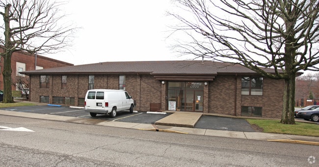
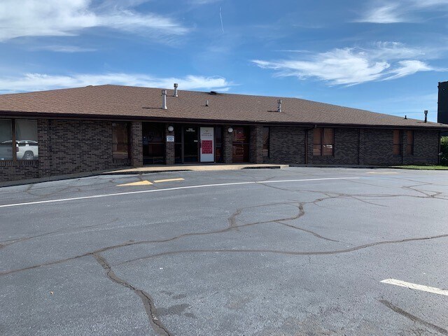
2000 Carter Ave
Huntington-Ashland, WV-KY-OH
LOTS 59-60-61 RANGE 4 EAST
038-09-12-002.00
Boyd
Officebuilding
Kentucky
COMMERCIAL
59-60-6
B and X Area of moderate flood hazard, usually the area between the limits of the 100-year and 500-year floods.
0.30 AC
2025
Downtown Ashland
2025
Huntington/Ashland
030200
NEARBY LISTINGS FOR SALE OR LEASE
DEMOGRAPHICS near 2000 Carter Ave
1 mile
3 mile
5 mile
2025 Total Population
5,618
29,883
54,299
2030 Population
5,634
29,405
53,324
Pop Growth 2025-2030
+ 0.28%
(1.60%)
(1.80%)
Average Age
41
41
42
2025 Total Households
2,465
12,527
21,927
HH Growth 2025-2030
+ 0.24%
(1.54%)
(1.81%)
Median Household Inc
$42,217
$53,210
$54,741
Avg Household Size
2.10
2.30
2.30
2025 Avg HH Vehicles
2.00
2.00
2.00
Median Home Value
$92,219
$130,502
$142,655
Median Year Built
1955
1964
1965
Nearby Places
Map Layers
Map Styles
 Street
 Aerial
Layers
 Traffic
 Biking
Places
Listings with unknown addresses are not visible on the map
- Restaurants
- Banks
- Shops
- Fitness
- Groceries
PUBLIC TRANSPORTATION
COMMUTER RAIL
Drive
Walk
Distance
2 min
11 min
0.6 mi
AIRPORT
Tri-State/Milton J Ferguson Field
Drive
Walk
Distance
Tri-State/Milton J Ferguson Field
19 min
11.6 mi
SALE & LEASE HISTORY
LISTING DATE
SALE/LEASE

Oct 07, 2022
For Sale
Nov 12, 2021
For Sale
Nearby Properties
Address
Land Use
TOTAL SIZE
Lot Size
Zoning
Address
Land Use
TOTAL SIZE
Lot Size
Zoning
6.96 AC
Z02
Address
Land Use
TOTAL SIZE
Lot Size
Zoning
36.49 AC
OTHER
Address
Land Use
TOTAL SIZE
Lot Size
Zoning
29.92 AC
Z02
Address
Land Use
TOTAL SIZE
Lot Size
Zoning
3,514 SF
21.96 AC
Z02
Address
Land Use
TOTAL SIZE
Lot Size
Zoning
0.99 AC
Z02
Address
Land Use
TOTAL SIZE
Lot Size
Zoning
16.29 AC
COMMERCIAL
Address
Land Use
TOTAL SIZE
Lot Size
Zoning
116,640 SF
0.97 AC
COMMERCIAL
Address
Land Use
TOTAL SIZE
Lot Size
Zoning
0.38 AC
COMMERCIAL
Address
Land Use
TOTAL SIZE
Lot Size
Zoning
4.47 AC
COMMERCIAL
Address
Land Use
TOTAL SIZE
Lot Size
Zoning
28.87 AC
COMMERCIAL
Address
Land Use
TOTAL SIZE
Lot Size
Zoning
91,786 SF
2.93 AC
Address
Land Use
TOTAL SIZE
Lot Size
Zoning
0.73 AC
Z02
Address
Land Use
TOTAL SIZE
Lot Size
Zoning
0.82 AC
COMMERCIAL
Address
Land Use
TOTAL SIZE
Lot Size
Zoning
209,728 SF
3.46 AC
Address
Land Use
TOTAL SIZE
Lot Size
Zoning
1.67 AC
RESIDENTIA
Address
Land Use
TOTAL SIZE
Lot Size
Zoning
1.63 AC
COMMERCIAL
Address
Land Use
TOTAL SIZE
Lot Size
Zoning
139,148 SF
Address
Land Use
TOTAL SIZE
Lot Size
Zoning
16.10 AC
Address
Land Use
TOTAL SIZE
Lot Size
Zoning
1.95 AC
COMMERCIAL
Address
Land Use
TOTAL SIZE
Lot Size
Zoning
22,592 SF
43.50 AC
OTHER
Address
Land Use
TOTAL SIZE
Lot Size
Zoning
4.30 AC
COMMERCIAL
Address
Land Use
TOTAL SIZE
Lot Size
Zoning
141 AC
COMMERCIAL
Address
Land Use
TOTAL SIZE
Lot Size
Zoning
47,107 SF
4.67 AC
Address
Land Use
TOTAL SIZE
Lot Size
Zoning
1.46 AC
COMMERCIAL
Address
Land Use
TOTAL SIZE
Lot Size
Zoning
Address
Land Use
TOTAL SIZE
Lot Size
Zoning
0.21 AC
Z02
Address
Land Use
TOTAL SIZE
Lot Size
Zoning
3.50 AC
Z02
Address
Land Use
TOTAL SIZE
Lot Size
Zoning
1,920 SF
33.30 AC
Z03
Address
Land Use
TOTAL SIZE
Lot Size
Zoning
2.50 AC
Address
Land Use
TOTAL SIZE
Lot Size
Zoning
12,540 SF
8.82 AC
The World's #1 Commercial Real Estate Marketplace
Connect with us
© 2026 CoStar Group
The information above has been obtained from sources believed reliable. While we do not doubt its accuracy we have not verified it and make no guarantee, warranty or representation about it. It is your responsibility to independently confirm its accuracy and completeness. Any projections, opinions, assumptions, or estimates used are for example only and do not represent the current or future performance of the property. The value of this transaction to you depends on tax and other factors which should be evaluated by your tax, financial, and legal advisors. You and your advisors should conduct a careful, independent investigation of the property to determine to your satisfaction the suitability of the property for your needs.