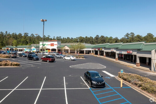
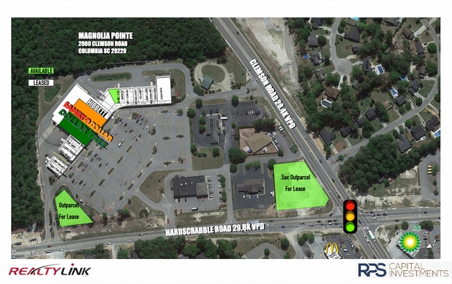
Property Record
2000 Clemson Rd, Columbia, SC 29229


Property Detail
2000 Clemson Rd
20200-02-07
PARCEL A & B #SU #PR RB405-2615 56-186
Commercialnec
Richland
PDD
South Carolina
B and X Area of moderate flood hazard, usually the area between the limits of the 100-year and 500-year floods.
11.98 AC
2025
Northeast Columbia
2024
Columbia
011417
Columbia, SC
69,202 SF
NEARBY LISTINGS FOR SALE OR LEASE
DEMOGRAPHICS near 2000 Clemson Rd
1 mile
3 mile
5 mile
2025 Total Population
9,437
65,282
122,960
2030 Population
9,720
67,172
127,258
Pop Growth 2025-2030
+ 3.00%
+ 2.90%
+ 3.50%
Average Age
38
38
38
2025 Total Households
3,726
24,610
47,360
HH Growth 2025-2030
+ 2.71%
+ 2.98%
+ 3.59%
Median Household Inc
$68,818
$76,372
$76,064
Avg Household Size
2.50
2.60
2.50
2025 Avg HH Vehicles
2.00
2.00
2.00
Median Home Value
$228,765
$253,167
$262,475
Median Year Built
2000
2002
2002
Nearby Places
Map Layers
Map Styles
 Street
 Aerial
Transit
 Traffic
 Biking
Places
Listings with unknown addresses are not visible on the map
- Restaurants
- Banks
- Shops
- Fitness
- Groceries
PUBLIC TRANSPORTATION
AIRPORT
Columbia Metro
Drive
Walk
Distance
Columbia Metro
43 min
25.7 mi
Freight Ports
North Charleston Terminal
Drive
Walk
Distance
North Charleston Terminal
142 min
122.8 mi
SALE & LEASE HISTORY
LISTING DATE
SALE/LEASE

Sep 25, 2016
For Lease
Mar 24, 2017
For Lease
Jul 07, 2017
For Lease
Jan 21, 2020
For Lease
Nearby Properties
Address
Land Use
TOTAL SIZE
Lot Size
Zoning
Address
Land Use
TOTAL SIZE
Lot Size
Zoning
231,760 SF
23.84 AC
M-1
Address
Land Use
TOTAL SIZE
Lot Size
Zoning
83,808 SF
95.58 AC
PDD
Address
Land Use
TOTAL SIZE
Lot Size
Zoning
333,002 SF
8.39 AC
GC
Address
Land Use
TOTAL SIZE
Lot Size
Zoning
244,269 SF
9.54 AC
GC
Address
Land Use
TOTAL SIZE
Lot Size
Zoning
563.44 AC
OI
Address
Land Use
TOTAL SIZE
Lot Size
Zoning
309,478 SF
8.87 AC
PDD
Address
Land Use
TOTAL SIZE
Lot Size
Zoning
325,344 SF
71.41 AC
HI
Address
Land Use
TOTAL SIZE
Lot Size
Zoning
306,612 SF
20.94 AC
GC
Address
Land Use
TOTAL SIZE
Lot Size
Zoning
301,627 SF
25.08 AC
PDD
Address
Land Use
TOTAL SIZE
Lot Size
Zoning
232,148 SF
14.16 AC
PDD
Address
Land Use
TOTAL SIZE
Lot Size
Zoning
140,567 SF
16.98 AC
M-1
Address
Land Use
TOTAL SIZE
Lot Size
Zoning
210,926 SF
22 AC
HI
Address
Land Use
TOTAL SIZE
Lot Size
Zoning
147,916 SF
4.69 AC
OI
Address
Land Use
TOTAL SIZE
Lot Size
Zoning
91,672 SF
12.18 AC
GC
Address
Land Use
TOTAL SIZE
Lot Size
Zoning
224,256 SF
25.49 AC
M-1
Address
Land Use
TOTAL SIZE
Lot Size
Zoning
51,803 SF
11.99 AC
M-1
Address
Land Use
TOTAL SIZE
Lot Size
Zoning
179,808 SF
12.85 AC
RM-HD
Address
Land Use
TOTAL SIZE
Lot Size
Zoning
50,000 SF
18.71 AC
RS-MD
Address
Land Use
TOTAL SIZE
Lot Size
Zoning
138,480 SF
23.02 AC
GC
Address
Land Use
TOTAL SIZE
Lot Size
Zoning
66,821 SF
6.32 AC
OI
Address
Land Use
TOTAL SIZE
Lot Size
Zoning
31,625 SF
3.30 AC
GC
Address
Land Use
TOTAL SIZE
Lot Size
Zoning
73,192 SF
6.12 AC
GC
Address
Land Use
TOTAL SIZE
Lot Size
Zoning
81,951 SF
11.81 AC
M-1
Address
Land Use
TOTAL SIZE
Lot Size
Zoning
148,809 SF
17.52 AC
M-1
Address
Land Use
TOTAL SIZE
Lot Size
Zoning
129,017 SF
14.70 AC
PDD
Address
Land Use
TOTAL SIZE
Lot Size
Zoning
161,727 SF
13.25 AC
GC
Address
Land Use
TOTAL SIZE
Lot Size
Zoning
143,072 SF
12.61 AC
PDD
Address
Land Use
TOTAL SIZE
Lot Size
Zoning
93,560 SF
9.39 AC
M-1
Address
Land Use
TOTAL SIZE
Lot Size
Zoning
87,363 SF
10.61 AC
M-1
Address
Land Use
TOTAL SIZE
Lot Size
Zoning
118,547 SF
10.64 AC
GC
The World's #1 Commercial Real Estate Marketplace
Connect with us
© 2026 CoStar Group
The information above has been obtained from sources believed reliable. While we do not doubt its accuracy we have not verified it and make no guarantee, warranty or representation about it. It is your responsibility to independently confirm its accuracy and completeness. Any projections, opinions, assumptions, or estimates used are for example only and do not represent the current or future performance of the property. The value of this transaction to you depends on tax and other factors which should be evaluated by your tax, financial, and legal advisors. You and your advisors should conduct a careful, independent investigation of the property to determine to your satisfaction the suitability of the property for your needs.