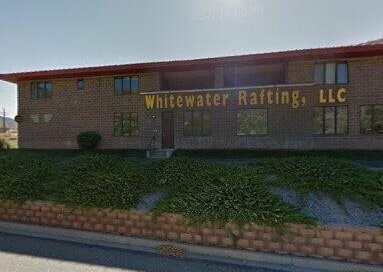
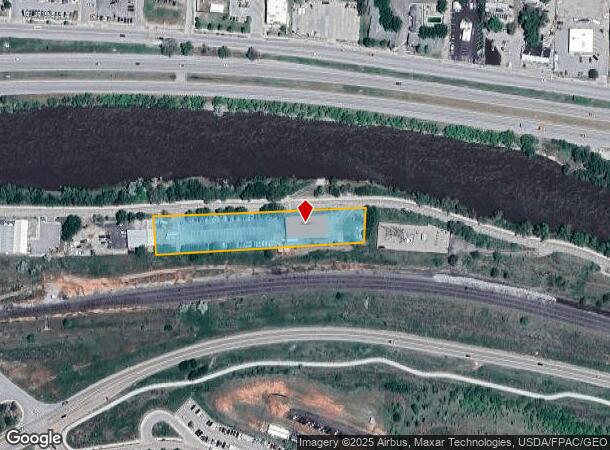
Property Record
2000 Devereux Rd, Glenwood Springs, CO 81601
NEARBY LISTINGS FOR SALE OR LEASE
Property Detail
2000 Devereux Rd
Other Market Areas
Colorado River Ind. Park Resub
Rifle, CO
SECTION: 5 TOWNSHIP: 6 RANGE: 89 SUBDIVISION: COLORADO RIVER IND. PARK RESUB LOT: 6 AND:- LOT: 7
R540084
Garfield
Sfr
Colorado
2025
6-7
2024
1.62 AC
951701
Colorado Northwest Area
6,900 SF
DEMOGRAPHICS near 2000 Devereux Rd
1 mile
3 mile
5 mile
2024 Total Population
3,660
9,500
12,376
2029 Population
3,814
9,863
12,838
Pop Growth 2024-2029
+ 4.21%
+ 3.82%
+ 3.73%
Average Age
38
39
39
2024 Total Households
1,360
3,754
4,814
HH Growth 2024-2029
+ 4.34%
+ 3.84%
+ 3.76%
Median Household Inc
$71,940
$68,712
$81,383
Avg Household Size
2.60
2.40
2.50
2024 Avg HH Vehicles
2.00
2.00
2.00
Median Home Value
$527,487
$576,592
$618,358
Median Year Built
1995
1977
1983
Nearby Places
Map Layers
Map Styles
 Street
 Aerial
Transit
 Traffic
 Biking
Places
Listings with unknown addresses are not visible on the map
- Restaurants
- Banks
- Shops
- Fitness
- Groceries
PUBLIC TRANSPORTATION
COMMUTER RAIL
Drive
Walk
Distance
6 min
3.1 mi
AIRPORT
Eagle County Regional
Drive
Walk
Distance
Eagle County Regional
38 min
29.2 mi
Aspen-Pitkin County/Sardy Field
Drive
Walk
Distance
Aspen-Pitkin County/Sardy Field
72 min
42.2 mi
Nearby Properties
Address
Land Use
TOTAL SIZE
Lot Size
Zoning
Address
Land Use
TOTAL SIZE
Lot Size
Zoning
58,900 SF
8.72 AC
Address
Land Use
TOTAL SIZE
Lot Size
Zoning
7,000 SF
10.25 AC
Address
Land Use
TOTAL SIZE
Lot Size
Zoning
Address
Land Use
TOTAL SIZE
Lot Size
Zoning
39,655 SF
37.08 AC
Address
Land Use
TOTAL SIZE
Lot Size
Zoning
45,110 SF
4.45 AC
Address
Land Use
TOTAL SIZE
Lot Size
Zoning
52,977 SF
0.60 AC
Address
Land Use
TOTAL SIZE
Lot Size
Zoning
36,321 SF
1.31 AC
Address
Land Use
TOTAL SIZE
Lot Size
Zoning
125,579 SF
10.64 AC
Address
Land Use
TOTAL SIZE
Lot Size
Zoning
89,560 SF
2.71 AC
Address
Land Use
TOTAL SIZE
Lot Size
Zoning
17,004 SF
5.65 AC
Address
Land Use
TOTAL SIZE
Lot Size
Zoning
45,855 SF
1.81 AC
Address
Land Use
TOTAL SIZE
Lot Size
Zoning
5,310 SF
4.85 AC
Address
Land Use
TOTAL SIZE
Lot Size
Zoning
42,256 SF
1.43 AC
Address
Land Use
TOTAL SIZE
Lot Size
Zoning
5,340 SF
1.55 AC
CL
Address
Land Use
TOTAL SIZE
Lot Size
Zoning
198.26 AC
PL
Address
Land Use
TOTAL SIZE
Lot Size
Zoning
61,845 SF
2.02 AC
Address
Land Use
TOTAL SIZE
Lot Size
Zoning
54,329 SF
2.71 AC
Address
Land Use
TOTAL SIZE
Lot Size
Zoning
32,072 SF
1.84 AC
Address
Land Use
TOTAL SIZE
Lot Size
Zoning
7,786 SF
2.92 AC
Address
Land Use
TOTAL SIZE
Lot Size
Zoning
22,053 SF
2.07 AC
Address
Land Use
TOTAL SIZE
Lot Size
Zoning
56,897 SF
3.26 AC
Address
Land Use
TOTAL SIZE
Lot Size
Zoning
42,546 SF
4.19 AC
Address
Land Use
TOTAL SIZE
Lot Size
Zoning
Address
Land Use
TOTAL SIZE
Lot Size
Zoning
21,216 SF
2.62 AC
R
Address
Land Use
TOTAL SIZE
Lot Size
Zoning
10,782 SF
2.44 AC
Address
Land Use
TOTAL SIZE
Lot Size
Zoning
14,117 SF
4.09 AC
Address
Land Use
TOTAL SIZE
Lot Size
Zoning
20,137 SF
0.40 AC
Address
Land Use
TOTAL SIZE
Lot Size
Zoning
10,559 SF
3.23 AC
Address
Land Use
TOTAL SIZE
Lot Size
Zoning
9,166 SF
81.76 AC
R
The World's #1 Commercial Real Estate Marketplace
Connect with us
© 2026 CoStar Group
The information above has been obtained from sources believed reliable. While we do not doubt its accuracy we have not verified it and make no guarantee, warranty or representation about it. It is your responsibility to independently confirm its accuracy and completeness. Any projections, opinions, assumptions, or estimates used are for example only and do not represent the current or future performance of the property. The value of this transaction to you depends on tax and other factors which should be evaluated by your tax, financial, and legal advisors. You and your advisors should conduct a careful, independent investigation of the property to determine to your satisfaction the suitability of the property for your needs.