Property Record
2000 E 54Th St N, Sioux Falls, SD 57104
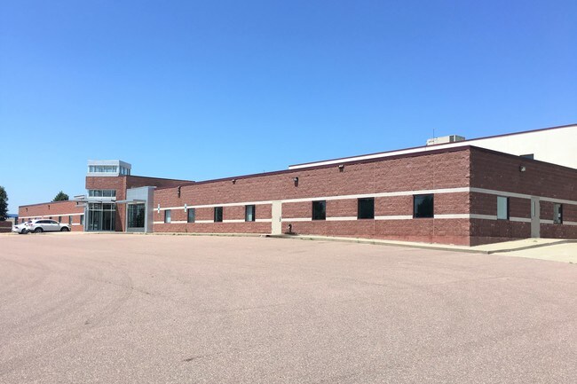

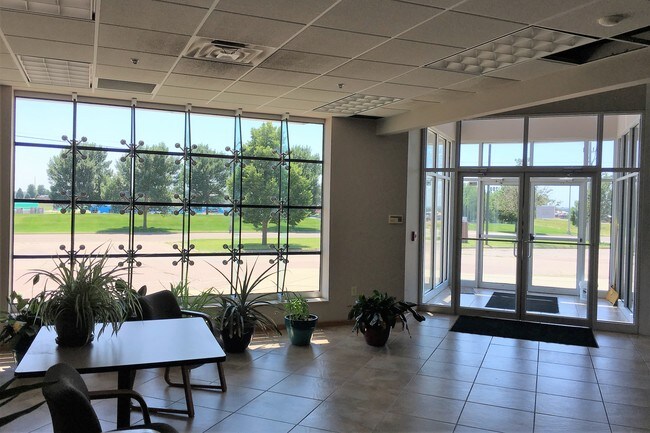

Property Detail
2000 E 54Th St N
66985
LOTS 1 & 2 & E 12 VAC ELEANOR AVE LYING ADJ LOT 1 BLOCK 1 SIOUX EMPIRE DEVELOPMENT PARK 5 ADDN TO CITY OF SIOUX FALLS
Manufacturinglight
Minnehaha
B and X Area of moderate flood hazard, usually the area between the limits of the 100-year and 500-year floods.
South Dakota
2024
1-2
2024
4.12 AC
000100
Other Market Areas
64,334 SF
Sioux Falls, SD-MN
NEARBY LISTINGS FOR SALE OR LEASE
DEMOGRAPHICS near 2000 E 54Th St N
1 mile
3 mile
5 mile
2024 Total Population
247
16,119
83,032
2029 Population
235
16,869
87,438
Pop Growth 2024-2029
(4.86%)
+ 4.65%
+ 5.31%
Average Age
49
39
38
2024 Total Households
115
5,827
34,199
HH Growth 2024-2029
(4.35%)
+ 5.10%
+ 5.74%
Median Household Inc
$57,413
$65,739
$64,420
Avg Household Size
2.10
2.40
2.30
2024 Avg HH Vehicles
2.00
2.00
2.00
Median Home Value
$151,351
$218,965
$258,174
Median Year Built
1985
1987
1978
Nearby Places
Map Layers
Map Styles
 Street
 Aerial
Transit
 Traffic
 Biking
Places
Listings with unknown addresses are not visible on the map
- Restaurants
- Banks
- Shops
- Fitness
- Groceries
PUBLIC TRANSPORTATION
AIRPORT
Joe Foss Field
Drive
Walk
Distance
Joe Foss Field
22 min
6.5 mi
Freight Ports
Port Milwaukee
Drive
Walk
Distance
Port Milwaukee
543 min
500.7 mi
SALE & LEASE HISTORY
LISTING DATE
SALE/LEASE

Aug 20, 2019
For Sale
Nearby Properties
Address
Land Use
TOTAL SIZE
Lot Size
Zoning
Address
Land Use
TOTAL SIZE
Lot Size
Zoning
348,059 SF
32.99 AC
Address
Land Use
TOTAL SIZE
Lot Size
Zoning
14,820 SF
80.57 AC
FP;FP
Address
Land Use
TOTAL SIZE
Lot Size
Zoning
300,920 SF
90.58 AC
Address
Land Use
TOTAL SIZE
Lot Size
Zoning
41.01 AC
FP;FP
Address
Land Use
TOTAL SIZE
Lot Size
Zoning
Address
Land Use
TOTAL SIZE
Lot Size
Zoning
50,160 SF
24.88 AC
Address
Land Use
TOTAL SIZE
Lot Size
Zoning
145,014 SF
14.41 AC
Address
Land Use
TOTAL SIZE
Lot Size
Zoning
149,520 SF
22.50 AC
Address
Land Use
TOTAL SIZE
Lot Size
Zoning
173,235 SF
10 AC
Address
Land Use
TOTAL SIZE
Lot Size
Zoning
33,416 SF
9.87 AC
Address
Land Use
TOTAL SIZE
Lot Size
Zoning
127,332 SF
28.18 AC
Address
Land Use
TOTAL SIZE
Lot Size
Zoning
18.37 AC
Address
Land Use
TOTAL SIZE
Lot Size
Zoning
62,856 SF
11.26 AC
Address
Land Use
TOTAL SIZE
Lot Size
Zoning
238,875 SF
21.92 AC
NO;SPECIAL
Address
Land Use
TOTAL SIZE
Lot Size
Zoning
127,500 SF
13.04 AC
Address
Land Use
TOTAL SIZE
Lot Size
Zoning
85,272 SF
4.83 AC
Address
Land Use
TOTAL SIZE
Lot Size
Zoning
1,806 SF
170.92 AC
FP;FP
Address
Land Use
TOTAL SIZE
Lot Size
Zoning
13.08 AC
Address
Land Use
TOTAL SIZE
Lot Size
Zoning
144,152 SF
12.89 AC
Address
Land Use
TOTAL SIZE
Lot Size
Zoning
5,040 SF
7.06 AC
Address
Land Use
TOTAL SIZE
Lot Size
Zoning
12,454 SF
13.30 AC
Address
Land Use
TOTAL SIZE
Lot Size
Zoning
111,104 SF
9.65 AC
NO;SPECIAL
Address
Land Use
TOTAL SIZE
Lot Size
Zoning
212,500 SF
12 AC
Address
Land Use
TOTAL SIZE
Lot Size
Zoning
175,340 SF
5.23 AC
Address
Land Use
TOTAL SIZE
Lot Size
Zoning
95,002 SF
8.32 AC
Address
Land Use
TOTAL SIZE
Lot Size
Zoning
137,336 SF
13.59 AC
Address
Land Use
TOTAL SIZE
Lot Size
Zoning
56,000 SF
21.37 AC
Address
Land Use
TOTAL SIZE
Lot Size
Zoning
81,440 SF
12.25 AC
Address
Land Use
TOTAL SIZE
Lot Size
Zoning
124,626 SF
15 AC
NO;SPECIAL
Address
Land Use
TOTAL SIZE
Lot Size
Zoning
120,000 SF
8.99 AC
The World's #1 Commercial Real Estate Marketplace
Connect with us
© 2026 CoStar Group
The information above has been obtained from sources believed reliable. While we do not doubt its accuracy we have not verified it and make no guarantee, warranty or representation about it. It is your responsibility to independently confirm its accuracy and completeness. Any projections, opinions, assumptions, or estimates used are for example only and do not represent the current or future performance of the property. The value of this transaction to you depends on tax and other factors which should be evaluated by your tax, financial, and legal advisors. You and your advisors should conduct a careful, independent investigation of the property to determine to your satisfaction the suitability of the property for your needs.