Property Record
2000 E 82Nd Ave, Hobart, IN 46342


Save to a Folder
{{folder.Name}}
{{folder.ListingIds.length}} Properties
{{folder.ListingIds.length}} Property
Create a New Folder
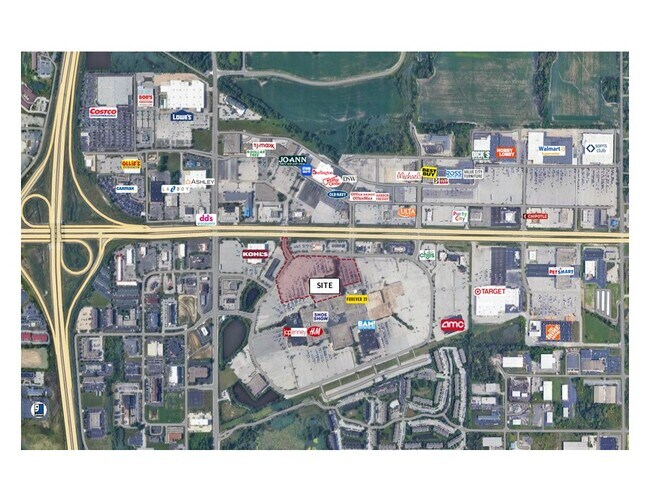
Property Detail
2000 E 82Nd Ave
Chicago-Naperville-Elgin, IL-IN
PT OF SW S.23 T.35 R.8 11.500 AC.
45-12-23-301-010.000-046
LAKE
Departmentstore
Indiana
B and X Area of moderate flood hazard, usually the area between the limits of the 100-year and 500-year floods.
1
2024
11.50 AC
2025
Indiana
042200
Chicago
181,849 SF
NEARBY LISTINGS FOR SALE OR LEASE
DEMOGRAPHICS near 2000 E 82Nd Ave
1 mile
3 mile
5 mile
2025 Total Population
1,739
24,348
94,005
2030 Population
1,739
24,360
94,740
Pop Growth 2025-2030
0.00%
+ 0.05%
+ 0.78%
Average Age
41
43
41
2025 Total Households
898
10,593
37,310
HH Growth 2025-2030
+ 0.11%
+ 0.12%
+ 0.73%
Median Household Inc
$58,316
$70,031
$77,090
Avg Household Size
1.90
2.20
2.40
2025 Avg HH Vehicles
1.00
2.00
2.00
Median Home Value
$231,045
$236,175
$243,099
Median Year Built
1992
1989
1977
Nearby Places
Map Layers
Map Styles
 Street
 Aerial
Layers
 Traffic
 Biking
Places
Listings with unknown addresses are not visible on the map
- Restaurants
- Banks
- Shops
- Fitness
- Groceries
SALE & LEASE HISTORY
LISTING DATE
SALE/LEASE

Apr 29, 2025
For Sale
Nearby Properties
Address
Land Use
TOTAL SIZE
Lot Size
Zoning
Address
Land Use
TOTAL SIZE
Lot Size
Zoning
1,002,000 SF
60.96 AC
Address
Land Use
TOTAL SIZE
Lot Size
Zoning
722,810 SF
64.65 AC
R33
Address
Land Use
TOTAL SIZE
Lot Size
Zoning
713,953 SF
39.61 AC
Address
Land Use
TOTAL SIZE
Lot Size
Zoning
552,100 SF
49.14 AC
Address
Land Use
TOTAL SIZE
Lot Size
Zoning
655,916 SF
46.27 AC
Address
Land Use
TOTAL SIZE
Lot Size
Zoning
598,983 SF
88 AC
Address
Land Use
TOTAL SIZE
Lot Size
Zoning
427,836 SF
54.72 AC
Address
Land Use
TOTAL SIZE
Lot Size
Zoning
590,274 SF
48.18 AC
Address
Land Use
TOTAL SIZE
Lot Size
Zoning
536,896 SF
20.08 AC
Address
Land Use
TOTAL SIZE
Lot Size
Zoning
129,204 SF
16.57 AC
Address
Land Use
TOTAL SIZE
Lot Size
Zoning
377,878 SF
21.58 AC
Address
Land Use
TOTAL SIZE
Lot Size
Zoning
184,544 SF
16.76 AC
Address
Land Use
TOTAL SIZE
Lot Size
Zoning
365,748 SF
17.44 AC
R33
Address
Land Use
TOTAL SIZE
Lot Size
Zoning
623,283 SF
44.38 AC
Address
Land Use
TOTAL SIZE
Lot Size
Zoning
276,540 SF
21.16 AC
Address
Land Use
TOTAL SIZE
Lot Size
Zoning
359,024 SF
43 AC
Address
Land Use
TOTAL SIZE
Lot Size
Zoning
263,968 SF
27.86 AC
Address
Land Use
TOTAL SIZE
Lot Size
Zoning
111,453 SF
15.21 AC
Address
Land Use
TOTAL SIZE
Lot Size
Zoning
291,060 SF
37.07 AC
Address
Land Use
TOTAL SIZE
Lot Size
Zoning
258,560 SF
17.30 AC
Address
Land Use
TOTAL SIZE
Lot Size
Zoning
236,904 SF
11.30 AC
R33
Address
Land Use
TOTAL SIZE
Lot Size
Zoning
159,548 SF
16.18 AC
Address
Land Use
TOTAL SIZE
Lot Size
Zoning
177,628 SF
12.95 AC
R3
Address
Land Use
TOTAL SIZE
Lot Size
Zoning
237,204 SF
28.82 AC
Address
Land Use
TOTAL SIZE
Lot Size
Zoning
194,027 SF
13.55 AC
Address
Land Use
TOTAL SIZE
Lot Size
Zoning
171,546 SF
19 AC
Address
Land Use
TOTAL SIZE
Lot Size
Zoning
143,060 SF
33.82 AC
Address
Land Use
TOTAL SIZE
Lot Size
Zoning
108,193 SF
2.42 AC
Address
Land Use
TOTAL SIZE
Lot Size
Zoning
329,040 SF
30.19 AC
Address
Land Use
TOTAL SIZE
Lot Size
Zoning
190,352 SF
12.36 AC
The World's #1 Commercial Real Estate Marketplace
Connect with us
© 2026 CoStar Group
The information above has been obtained from sources believed reliable. While we do not doubt its accuracy we have not verified it and make no guarantee, warranty or representation about it. It is your responsibility to independently confirm its accuracy and completeness. Any projections, opinions, assumptions, or estimates used are for example only and do not represent the current or future performance of the property. The value of this transaction to you depends on tax and other factors which should be evaluated by your tax, financial, and legal advisors. You and your advisors should conduct a careful, independent investigation of the property to determine to your satisfaction the suitability of the property for your needs.