Property Record
2000 E Kansas Ave, Mcpherson, KS 67460
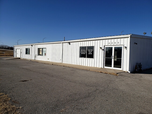


Property Detail
2000 E Kansas Ave
138-27-0-10-07-005.00-0
EASTGATE ADDITION, S27, T19, R03, LT 1 EX E80' BLK 2
Warehouse
McPherson
B6
Kansas
AE The base floodplain where base flood elevations are provided. AE Zones are now used on new format FIRMs instead of A1-A30 Zones.
1
2025
0.52 AC
2025
Kansas Area
788600
Other Market Areas
4,000 SF
McPherson, KS
NEARBY LISTINGS FOR SALE OR LEASE
DEMOGRAPHICS near 2000 E Kansas Ave
1 mile
3 mile
5 mile
2025 Total Population
3,142
14,962
15,645
2030 Population
3,195
15,166
15,847
Pop Growth 2025-2030
+ 1.69%
+ 1.36%
+ 1.29%
Average Age
37
40
40
2025 Total Households
1,203
5,991
6,254
HH Growth 2025-2030
+ 1.83%
+ 1.39%
+ 1.31%
Median Household Inc
$69,204
$76,720
$76,929
Avg Household Size
2.40
2.30
2.30
2025 Avg HH Vehicles
2.00
2.00
2.00
Median Home Value
$235,714
$216,564
$216,973
Median Year Built
1982
1976
1976
Nearby Places
Map Layers
Map Styles
 Street
 Aerial
Layers
 Traffic
 Biking
Places
Listings with unknown addresses are not visible on the map
- Restaurants
- Banks
- Shops
- Fitness
- Groceries
SALE & LEASE HISTORY
LISTING DATE
SALE/LEASE

Nov 16, 2020
For Lease
Jan 15, 2021
For Sale
Nearby Properties
Address
Land Use
TOTAL SIZE
Lot Size
Zoning
Address
Land Use
TOTAL SIZE
Lot Size
Zoning
19,502 SF
39.67 AC
Address
Land Use
TOTAL SIZE
Lot Size
Zoning
2,400 SF
405.10 AC
Address
Land Use
TOTAL SIZE
Lot Size
Zoning
158,285 SF
43.11 AC
Address
Land Use
TOTAL SIZE
Lot Size
Zoning
10,384 SF
10.01 AC
Address
Land Use
TOTAL SIZE
Lot Size
Zoning
516,003 SF
94.95 AC
Address
Land Use
TOTAL SIZE
Lot Size
Zoning
150,465 SF
13.17 AC
Address
Land Use
TOTAL SIZE
Lot Size
Zoning
50,269 SF
5.27 AC
Address
Land Use
TOTAL SIZE
Lot Size
Zoning
84,670 SF
33.75 AC
Address
Land Use
TOTAL SIZE
Lot Size
Zoning
2,080 SF
189.39 AC
Address
Land Use
TOTAL SIZE
Lot Size
Zoning
15,083 SF
15.74 AC
Address
Land Use
TOTAL SIZE
Lot Size
Zoning
573,437 SF
151.89 AC
Address
Land Use
TOTAL SIZE
Lot Size
Zoning
125,666 SF
7.56 AC
Address
Land Use
TOTAL SIZE
Lot Size
Zoning
64,152 SF
5.09 AC
Address
Land Use
TOTAL SIZE
Lot Size
Zoning
49,496 SF
9.83 AC
Address
Land Use
TOTAL SIZE
Lot Size
Zoning
48,617 SF
6.34 AC
B6
Address
Land Use
TOTAL SIZE
Lot Size
Zoning
52,060 SF
17.13 AC
Address
Land Use
TOTAL SIZE
Lot Size
Zoning
31,840 SF
4.44 AC
Address
Land Use
TOTAL SIZE
Lot Size
Zoning
25,777 SF
4.25 AC
I2
Address
Land Use
TOTAL SIZE
Lot Size
Zoning
55,426 SF
2.77 AC
Address
Land Use
TOTAL SIZE
Lot Size
Zoning
32,489 SF
0.67 AC
B3
Address
Land Use
TOTAL SIZE
Lot Size
Zoning
51,052 SF
3.51 AC
Address
Land Use
TOTAL SIZE
Lot Size
Zoning
565 SF
54.98 AC
Address
Land Use
TOTAL SIZE
Lot Size
Zoning
42,112 SF
6.24 AC
Address
Land Use
TOTAL SIZE
Lot Size
Zoning
38,200 SF
3.33 AC
R2
Address
Land Use
TOTAL SIZE
Lot Size
Zoning
27,835 SF
4.81 AC
I2
Address
Land Use
TOTAL SIZE
Lot Size
Zoning
16,296 SF
9.11 AC
Address
Land Use
TOTAL SIZE
Lot Size
Zoning
5,000 SF
55.21 AC
Address
Land Use
TOTAL SIZE
Lot Size
Zoning
20,620 SF
9.97 AC
Address
Land Use
TOTAL SIZE
Lot Size
Zoning
23,666 SF
1.18 AC
Address
Land Use
TOTAL SIZE
Lot Size
Zoning
18,918 SF
2.34 AC
The World's #1 Commercial Real Estate Marketplace
Connect with us
© 2026 CoStar Group
The information above has been obtained from sources believed reliable. While we do not doubt its accuracy we have not verified it and make no guarantee, warranty or representation about it. It is your responsibility to independently confirm its accuracy and completeness. Any projections, opinions, assumptions, or estimates used are for example only and do not represent the current or future performance of the property. The value of this transaction to you depends on tax and other factors which should be evaluated by your tax, financial, and legal advisors. You and your advisors should conduct a careful, independent investigation of the property to determine to your satisfaction the suitability of the property for your needs.