Property Record
2000 E Matthews Ave, Jonesboro, AR 72401
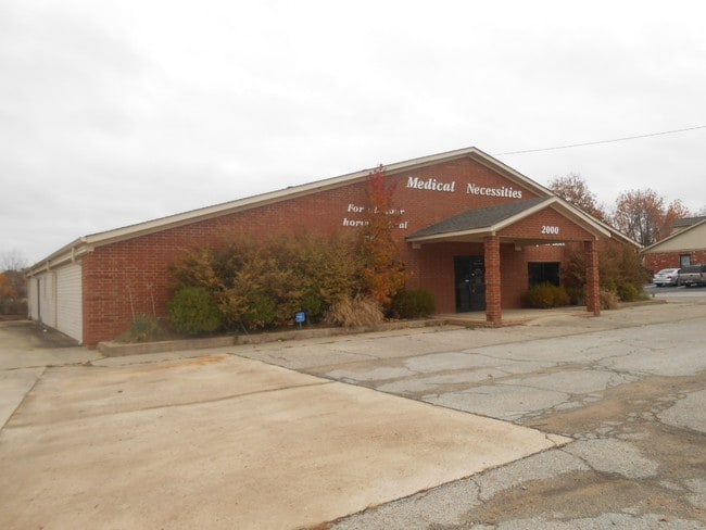

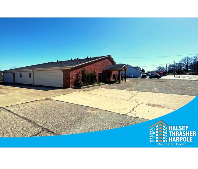
Property Detail
2000 E Matthews Ave
01-144201-01400
PT NE NE 50X161.6 JBORO CITY PT TRACT B
Officebuilding
Craighead
B and X Area of moderate flood hazard, usually the area between the limits of the 100-year and 500-year floods.
Arkansas
2024
0.17 AC
2025
Downtown Jonesboro
000102
Other Market Areas
6,468 SF
Jonesboro, AR
NEARBY LISTINGS FOR SALE OR LEASE
DEMOGRAPHICS near 2000 E Matthews Ave
1 mile
3 mile
5 mile
2025 Total Population
8,237
53,489
80,120
2030 Population
8,513
55,651
83,414
Pop Growth 2025-2030
+ 3.35%
+ 4.04%
+ 4.11%
Average Age
32
36
37
2025 Total Households
2,764
21,601
31,693
HH Growth 2025-2030
+ 4.78%
+ 4.49%
+ 4.48%
Median Household Inc
$34,272
$43,892
$54,887
Avg Household Size
2.10
2.30
2.40
2025 Avg HH Vehicles
1.00
2.00
2.00
Median Home Value
$225,210
$173,253
$197,856
Median Year Built
1982
1989
1993
Nearby Places
Map Layers
Map Styles
 Street
 Aerial
Transit
 Traffic
 Biking
Places
Listings with unknown addresses are not visible on the map
- Restaurants
- Banks
- Shops
- Fitness
- Groceries
SALE & LEASE HISTORY
LISTING DATE
SALE/LEASE

May 05, 2021
For Sale
Dec 06, 2016
For Sale
Nearby Properties
Address
Land Use
TOTAL SIZE
Lot Size
Zoning
Address
Land Use
TOTAL SIZE
Lot Size
Zoning
38,357 SF
5.41 AC
Address
Land Use
TOTAL SIZE
Lot Size
Zoning
353,512 SF
15.01 AC
Address
Land Use
TOTAL SIZE
Lot Size
Zoning
45,783 SF
346.92 AC
Address
Land Use
TOTAL SIZE
Lot Size
Zoning
61,868 SF
15.69 AC
Address
Land Use
TOTAL SIZE
Lot Size
Zoning
56,279 SF
8.37 AC
Address
Land Use
TOTAL SIZE
Lot Size
Zoning
219,080 SF
10.93 AC
Address
Land Use
TOTAL SIZE
Lot Size
Zoning
141,878 SF
8.30 AC
Address
Land Use
TOTAL SIZE
Lot Size
Zoning
19,078 SF
55.47 AC
Address
Land Use
TOTAL SIZE
Lot Size
Zoning
18,470 SF
1.54 AC
Address
Land Use
TOTAL SIZE
Lot Size
Zoning
99,212 SF
7.49 AC
Address
Land Use
TOTAL SIZE
Lot Size
Zoning
120,208 SF
10.21 AC
Address
Land Use
TOTAL SIZE
Lot Size
Zoning
152,814 SF
13.62 AC
Address
Land Use
TOTAL SIZE
Lot Size
Zoning
6.89 AC
Address
Land Use
TOTAL SIZE
Lot Size
Zoning
Address
Land Use
TOTAL SIZE
Lot Size
Zoning
65,020 SF
0.30 AC
Address
Land Use
TOTAL SIZE
Lot Size
Zoning
29,766 SF
2.41 AC
Address
Land Use
TOTAL SIZE
Lot Size
Zoning
86,075 SF
4.82 AC
Address
Land Use
TOTAL SIZE
Lot Size
Zoning
79,649 SF
2.71 AC
Address
Land Use
TOTAL SIZE
Lot Size
Zoning
62,735 SF
5.05 AC
Address
Land Use
TOTAL SIZE
Lot Size
Zoning
17,155 SF
16.91 AC
Address
Land Use
TOTAL SIZE
Lot Size
Zoning
104,717 SF
8.70 AC
Address
Land Use
TOTAL SIZE
Lot Size
Zoning
144,936 SF
10.40 AC
Address
Land Use
TOTAL SIZE
Lot Size
Zoning
68,081 SF
1.90 AC
Address
Land Use
TOTAL SIZE
Lot Size
Zoning
49,975 SF
12.66 AC
Address
Land Use
TOTAL SIZE
Lot Size
Zoning
47,512 SF
6.98 AC
Address
Land Use
TOTAL SIZE
Lot Size
Zoning
10,080 SF
2.88 AC
Address
Land Use
TOTAL SIZE
Lot Size
Zoning
60,004 SF
2.61 AC
Address
Land Use
TOTAL SIZE
Lot Size
Zoning
62,340 SF
6.78 AC
Address
Land Use
TOTAL SIZE
Lot Size
Zoning
49,568 SF
14 AC
The World's #1 Commercial Real Estate Marketplace
Connect with us
© 2026 CoStar Group
The information above has been obtained from sources believed reliable. While we do not doubt its accuracy we have not verified it and make no guarantee, warranty or representation about it. It is your responsibility to independently confirm its accuracy and completeness. Any projections, opinions, assumptions, or estimates used are for example only and do not represent the current or future performance of the property. The value of this transaction to you depends on tax and other factors which should be evaluated by your tax, financial, and legal advisors. You and your advisors should conduct a careful, independent investigation of the property to determine to your satisfaction the suitability of the property for your needs.