Property Record
2000 E Texas St, Bossier City, LA 71111
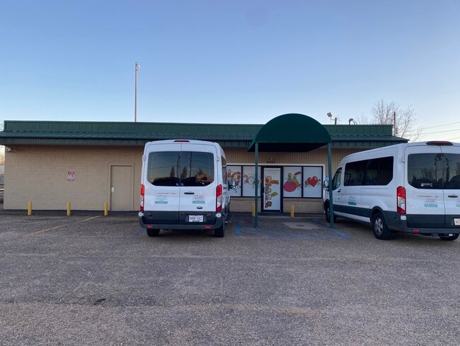

This Property Is For Sale
Property Detail
2000 E Texas St
Shreveport-Bossier City, LA
BEGIN ON S. R/W LINE OF HWY. 80 680 FT. ELY OF THE INTERSECTION OF HWY. 80 & HAMILTON RD. THENCE CONTINUE E. ALONG SAID R/W 1
129401
Bossier
Publicschool
Louisiana
B and X Area of moderate flood hazard, usually the area between the limits of the 100-year and 500-year floods.
3
2024
0.34 AC
2024
Bossier Parish
011300
Shreveport/Bossier City
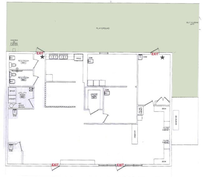
2,320 SF
NEARBY LISTINGS FOR SALE OR LEASE
DEMOGRAPHICS near 2000 E Texas St
1 mile
3 mile
5 mile
2025 Total Population
7,503
46,134
106,384
2030 Population
7,657
46,371
106,139
Pop Growth 2025-2030
+ 2.05%
+ 0.51%
(0.23%)
Average Age
36
39
39
2025 Total Households
3,096
19,468
45,170
HH Growth 2025-2030
+ 2.00%
+ 0.40%
(0.26%)
Median Household Inc
$36,480
$39,523
$49,767
Avg Household Size
2.30
2.20
2.20
2025 Avg HH Vehicles
1.00
1.00
1.00
Median Home Value
$96,700
$130,199
$167,835
Median Year Built
1969
1968
1969
Nearby Places
Map Layers
Map Styles
 Street
 Aerial
Transit
 Traffic
 Biking
Places
Listings with unknown addresses are not visible on the map
- Restaurants
- Banks
- Shops
- Fitness
- Groceries
Nearby Properties
Address
Land Use
TOTAL SIZE
Lot Size
Zoning
Address
Land Use
TOTAL SIZE
Lot Size
Zoning
0.78 AC
Address
Land Use
TOTAL SIZE
Lot Size
Zoning
66,239 SF
111 AC
Address
Land Use
TOTAL SIZE
Lot Size
Zoning
100 SF
7.17 AC
Address
Land Use
TOTAL SIZE
Lot Size
Zoning
239,598 SF
4.10 AC
Address
Land Use
TOTAL SIZE
Lot Size
Zoning
280,756 SF
3 AC
Address
Land Use
TOTAL SIZE
Lot Size
Zoning
166,418 SF
32 AC
Address
Land Use
TOTAL SIZE
Lot Size
Zoning
1,700 SF
28 AC
Address
Land Use
TOTAL SIZE
Lot Size
Zoning
Address
Land Use
TOTAL SIZE
Lot Size
Zoning
100 SF
0.74 AC
Address
Land Use
TOTAL SIZE
Lot Size
Zoning
100 SF
3.37 AC
Address
Land Use
TOTAL SIZE
Lot Size
Zoning
66,828 SF
74.46 AC
Address
Land Use
TOTAL SIZE
Lot Size
Zoning
348,362 SF
22 AC
Address
Land Use
TOTAL SIZE
Lot Size
Zoning
128,389 SF
7.77 AC
Address
Land Use
TOTAL SIZE
Lot Size
Zoning
100 SF
1.34 AC
Address
Land Use
TOTAL SIZE
Lot Size
Zoning
100 SF
4.21 AC
Address
Land Use
TOTAL SIZE
Lot Size
Zoning
222,616 SF
0.28 AC
Address
Land Use
TOTAL SIZE
Lot Size
Zoning
100 SF
3.08 AC
Address
Land Use
TOTAL SIZE
Lot Size
Zoning
Address
Land Use
TOTAL SIZE
Lot Size
Zoning
192,369 SF
7 AC
Address
Land Use
TOTAL SIZE
Lot Size
Zoning
100 SF
4.19 AC
Address
Land Use
TOTAL SIZE
Lot Size
Zoning
100 SF
0.48 AC
Address
Land Use
TOTAL SIZE
Lot Size
Zoning
100 SF
13.17 AC
Address
Land Use
TOTAL SIZE
Lot Size
Zoning
100 SF
2.48 AC
Address
Land Use
TOTAL SIZE
Lot Size
Zoning
Address
Land Use
TOTAL SIZE
Lot Size
Zoning
6,494 SF
74.46 AC
Address
Land Use
TOTAL SIZE
Lot Size
Zoning
107,841 SF
2 AC
Address
Land Use
TOTAL SIZE
Lot Size
Zoning
100 SF
6.52 AC
Address
Land Use
TOTAL SIZE
Lot Size
Zoning
100 SF
2.59 AC
Address
Land Use
TOTAL SIZE
Lot Size
Zoning
100 SF
3.98 AC
Address
Land Use
TOTAL SIZE
Lot Size
Zoning
205,616 SF
0.63 AC
The World's #1 Commercial Real Estate Marketplace
Connect with us
© 2026 CoStar Group
The information above has been obtained from sources believed reliable. While we do not doubt its accuracy we have not verified it and make no guarantee, warranty or representation about it. It is your responsibility to independently confirm its accuracy and completeness. Any projections, opinions, assumptions, or estimates used are for example only and do not represent the current or future performance of the property. The value of this transaction to you depends on tax and other factors which should be evaluated by your tax, financial, and legal advisors. You and your advisors should conduct a careful, independent investigation of the property to determine to your satisfaction the suitability of the property for your needs.