Property Record
2000 E Wyatt Earp Blvd, Dodge City, KS 67801


NEARBY LISTINGS FOR SALE OR LEASE
-
-
View all Dodge City listings for sale on LoopNet.com
Property Detail
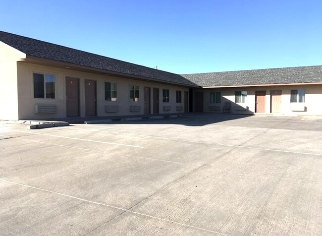
2000 E Wyatt Earp Blvd
Dodge City, KS
East Wyatt Earp Addition
099-30-0-30-02-002.00-0
EAST WYATT EARP ADDITION, S30, T26, R24, BLOCK 1, LOT 2, ACRES 2
Motel
Ford
X
Kansas
20057C0215E
2
2025
2.08 AC
2025
Kansas Area
962101
Other Market Areas
2,598 SF
DEMOGRAPHICS near 2000 E Wyatt Earp Blvd
1 Mile
3 Mile
5 Mile
2024 Total Population
1,811
25,948
29,775
2029 Population
1,795
25,540
29,307
Pop Growth 2024-2029
(0.88%)
(1.57%)
(1.57%)
Average Age
31
34
34
2024 Total Households
541
8,366
9,662
HH Growth 2024-2029
(0.92%)
(1.59%)
(1.58%)
Median Household Inc
$38,425
$59,281
$61,095
Avg Household Size
3.10
3.00
3.00
2024 Avg HH Vehicles
2.00
2.00
2.00
Median Home Value
$59,653
$112,604
$120,675
Median Year Built
1976
1970
1971
Nearby Places
Map Layers
Map Styles
 Street
 Aerial
- Restaurants
- Banks
- Shops
- Fitness
- Groceries
PUBLIC TRANSPORTATION
COMMUTER RAIL
Dodge City Amtrak Station (Southwest Chief - Amtrak)
DRIVE
WALK
Distance
Dodge City Amtrak Station (Southwest Chief - Amtrak)
3 min
1.7 mi
Freight Ports
Tulsa Port Of Catoosa
DRIVE
WALK
Distance
Tulsa Port Of Catoosa
384 min
341.8 mi
SALE & LEASE HISTORY
LISTING DATE
SALE/LEASE

Feb 29, 2024
For Sale
Nearby Properties
Address
Land Use
TOTAL SIZE
Lot Size
Zoning
Address
Land Use
TOTAL SIZE
Lot Size
Zoning
390,187 SF
137.30 AC
Address
Land Use
TOTAL SIZE
Lot Size
Zoning
345,768 SF
39.04 AC
Address
Land Use
TOTAL SIZE
Lot Size
Zoning
213,605 SF
7.54 AC
Address
Land Use
TOTAL SIZE
Lot Size
Zoning
198,802 SF
4.50 AC
Address
Land Use
TOTAL SIZE
Lot Size
Zoning
80,667 SF
76.81 AC
Address
Land Use
TOTAL SIZE
Lot Size
Zoning
181,759 SF
107.80 AC
Address
Land Use
TOTAL SIZE
Lot Size
Zoning
57,670 SF
40 AC
Address
Land Use
TOTAL SIZE
Lot Size
Zoning
139,595 SF
12.30 AC
Address
Land Use
TOTAL SIZE
Lot Size
Zoning
79,746 SF
2.10 AC
Address
Land Use
TOTAL SIZE
Lot Size
Zoning
63,557 SF
29.50 AC
Address
Land Use
TOTAL SIZE
Lot Size
Zoning
63,818 SF
4.06 AC
Address
Land Use
TOTAL SIZE
Lot Size
Zoning
37,310 SF
5.30 AC
Address
Land Use
TOTAL SIZE
Lot Size
Zoning
59,445 SF
30.50 AC
Address
Land Use
TOTAL SIZE
Lot Size
Zoning
85,946 SF
61.70 AC
Address
Land Use
TOTAL SIZE
Lot Size
Zoning
61,521 SF
6.97 AC
Address
Land Use
TOTAL SIZE
Lot Size
Zoning
59,445 SF
10.63 AC
Address
Land Use
TOTAL SIZE
Lot Size
Zoning
7,956 SF
48.52 AC
Address
Land Use
TOTAL SIZE
Lot Size
Zoning
171,419 SF
4.70 AC
Address
Land Use
TOTAL SIZE
Lot Size
Zoning
218,050 SF
36.50 AC
Address
Land Use
TOTAL SIZE
Lot Size
Zoning
30,214 SF
16.62 AC
Address
Land Use
TOTAL SIZE
Lot Size
Zoning
28,704 SF
2.10 AC
Address
Land Use
TOTAL SIZE
Lot Size
Zoning
5,386 SF
109 AC
Address
Land Use
TOTAL SIZE
Lot Size
Zoning
40,037 SF
0.35 AC
Address
Land Use
TOTAL SIZE
Lot Size
Zoning
19,706 SF
1.40 AC
Address
Land Use
TOTAL SIZE
Lot Size
Zoning
27,986 SF
5.52 AC
Address
Land Use
TOTAL SIZE
Lot Size
Zoning
44,608 SF
0.81 AC
Address
Land Use
TOTAL SIZE
Lot Size
Zoning
72,192 SF
18 AC
Address
Land Use
TOTAL SIZE
Lot Size
Zoning
118 AC
Address
Land Use
TOTAL SIZE
Lot Size
Zoning
13,071 SF
2.23 AC
Address
Land Use
TOTAL SIZE
Lot Size
Zoning
13,727 SF
1.80 AC
The World's #1 Commercial Real Estate Marketplace
Connect with us
© 2025 CoStar Group
The information above has been obtained from sources believed reliable. While we do not doubt its accuracy we have not verified it and make no guarantee, warranty or representation about it. It is your responsibility to independently confirm its accuracy and completeness. Any projections, opinions, assumptions, or estimates used are for example only and do not represent the current or future performance of the property. The value of this transaction to you depends on tax and other factors which should be evaluated by your tax, financial, and legal advisors. You and your advisors should conduct a careful, independent investigation of the property to determine to your satisfaction the suitability of the property for your needs.