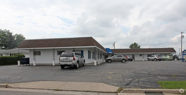
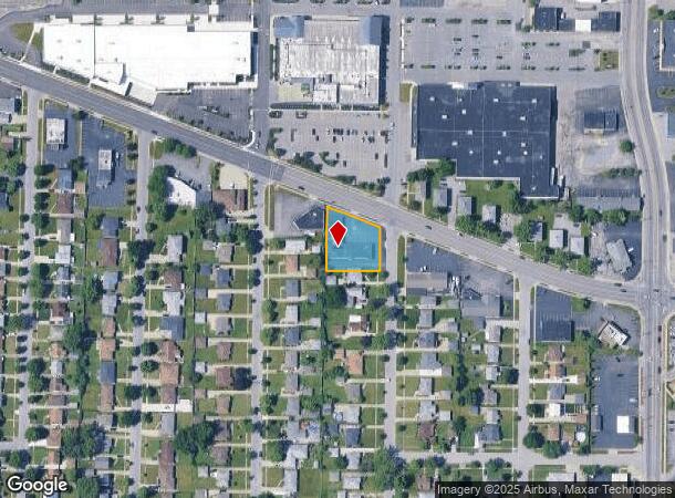
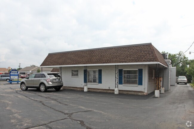
Property Record
2000 Eggert Rd, Buffalo, NY 14226
NEARBY LISTINGS FOR SALE OR LEASE
Property Detail
2000 Eggert Rd
Buffalo-Cheektowaga-Niagara Falls, NY
North Bailey Meadows
142289-067-480-0003-002-000
84 12 7 1299 189 190 191 N BAILEY MEADOWS, PT.1
Storesoffices
Erie
X
New York
36029C0205H
2.000
2025
0.56 AC
2024
North
009301
Buffalo/Niagara Falls
5,778 SF
DEMOGRAPHICS near 2000 Eggert Rd
1 Mile
3 Mile
5 Mile
2024 Total Population
18,236
155,169
355,679
2029 Population
18,275
153,831
350,553
Pop Growth 2024-2029
+ 0.21%
(0.86%)
(1.44%)
Average Age
40
39
40
2024 Total Households
7,700
64,639
150,452
HH Growth 2024-2029
+ 0.13%
(0.93%)
(1.49%)
Median Household Inc
$64,176
$66,204
$59,393
Avg Household Size
2.30
2.20
2.20
2024 Avg HH Vehicles
2.00
2.00
1.00
Median Home Value
$163,901
$183,585
$179,765
Median Year Built
1955
1953
1952
Nearby Places
- Restaurants
- Banks
- Shops
- Fitness
- Groceries
PUBLIC TRANSPORTATION
COMMUTER RAIL
DRIVE
WALK
Distance
17 min
8.8 mi
DRIVE
WALK
Distance
17 min
9.2 mi
AIRPORT
Buffalo Niagara International
DRIVE
WALK
Distance
Buffalo Niagara International
14 min
6.5 mi
Niagara Falls International
DRIVE
WALK
Distance
Niagara Falls International
24 min
12.5 mi
Nearby Properties
Address
Land Use
TOTAL SIZE
Lot Size
Zoning
Address
Land Use
TOTAL SIZE
Lot Size
Zoning
2,592,064 SF
1,057.90 AC
Address
Land Use
TOTAL SIZE
Lot Size
Zoning
135,396 SF
146.32 AC
D-E
Address
Land Use
TOTAL SIZE
Lot Size
Zoning
109,328 SF
12.77 AC
GB
Address
Land Use
TOTAL SIZE
Lot Size
Zoning
646,259 SF
16.31 AC
D-M
Address
Land Use
TOTAL SIZE
Lot Size
Zoning
409,925 SF
36.41 AC
CTR-5
Address
Land Use
TOTAL SIZE
Lot Size
Zoning
132,940 SF
41.50 AC
CF
Address
Land Use
TOTAL SIZE
Lot Size
Zoning
177,000 SF
14.91 AC
CF
Address
Land Use
TOTAL SIZE
Lot Size
Zoning
16,065 SF
19.75 AC
Address
Land Use
TOTAL SIZE
Lot Size
Zoning
8,565 SF
22.65 AC
Address
Land Use
TOTAL SIZE
Lot Size
Zoning
12,262 SF
29 AC
MFR-5
Address
Land Use
TOTAL SIZE
Lot Size
Zoning
19,608 SF
0.45 AC
N-3C
Address
Land Use
TOTAL SIZE
Lot Size
Zoning
70,261 SF
14.63 AC
CTR-5
Address
Land Use
TOTAL SIZE
Lot Size
Zoning
100,737 SF
21.10 AC
CTR-5
Address
Land Use
TOTAL SIZE
Lot Size
Zoning
117,980 SF
14.40 AC
CTR-5
Address
Land Use
TOTAL SIZE
Lot Size
Zoning
540,154 SF
7.06 AC
D-E
Address
Land Use
TOTAL SIZE
Lot Size
Zoning
181,897 SF
15.30 AC
CTR-2.5
Address
Land Use
TOTAL SIZE
Lot Size
Zoning
8,842 SF
29.30 AC
Address
Land Use
TOTAL SIZE
Lot Size
Zoning
71,053 SF
2.52 AC
OB
Address
Land Use
TOTAL SIZE
Lot Size
Zoning
17,778 SF
14 AC
GB
Address
Land Use
TOTAL SIZE
Lot Size
Zoning
197,430 SF
8.20 AC
Address
Land Use
TOTAL SIZE
Lot Size
Zoning
197,430 SF
7.35 AC
Address
Land Use
TOTAL SIZE
Lot Size
Zoning
3,456 SF
6.90 AC
MFR-5
Address
Land Use
TOTAL SIZE
Lot Size
Zoning
83,256 SF
8.01 AC
NCD
Address
Land Use
TOTAL SIZE
Lot Size
Zoning
191,420 SF
59.30 AC
Address
Land Use
TOTAL SIZE
Lot Size
Zoning
132,000 SF
9.40 AC
Address
Land Use
TOTAL SIZE
Lot Size
Zoning
3,712 SF
36.08 AC
03RA
Address
Land Use
TOTAL SIZE
Lot Size
Zoning
7,753 SF
1 AC
N-1C
Address
Land Use
TOTAL SIZE
Lot Size
Zoning
6,384 SF
13.40 AC
Address
Land Use
TOTAL SIZE
Lot Size
Zoning
122,669 SF
7.94 AC
CTR-2.5
Address
Land Use
TOTAL SIZE
Lot Size
Zoning
109,461 SF
7.90 AC
CTR-5
The World's #1 Commercial Real Estate Marketplace
Connect with us
© 2025 CoStar Group
The information above has been obtained from sources believed reliable. While we do not doubt its accuracy we have not verified it and make no guarantee, warranty or representation about it. It is your responsibility to independently confirm its accuracy and completeness. Any projections, opinions, assumptions, or estimates used are for example only and do not represent the current or future performance of the property. The value of this transaction to you depends on tax and other factors which should be evaluated by your tax, financial, and legal advisors. You and your advisors should conduct a careful, independent investigation of the property to determine to your satisfaction the suitability of the property for your needs.