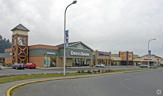
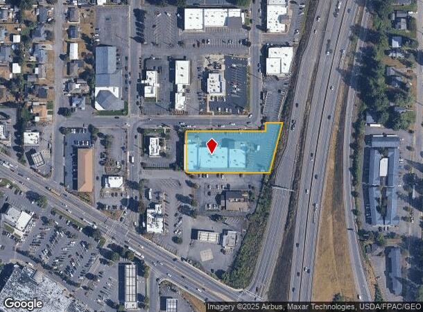
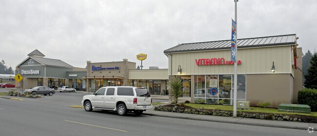
Property Record
2000 Haviland St, Centralia, WA 98531
NEARBY LISTINGS FOR SALE OR LEASE
Property Detail
2000 Haviland St
Other Market Areas
Mt View Add
Centralia, WA
SECTION 06 TOWNSHIP 14N RANGE 02W PT LOTS 5-10 BLK 3 MT VIEW ADD PT LOT 16 J&J ACRE TRS W HWY & PT VAC ALLEY & ST ADJ
002918-010-006
Lewis
Storebuilding
Washington
2024
16,5-
2025
1.33 AC
970300
Washington State Area
22,288 SF
DEMOGRAPHICS near 2000 Haviland St
1 Mile
3 Mile
5 Mile
2024 Total Population
7,358
26,719
33,618
2029 Population
8,232
29,945
37,568
Pop Growth 2024-2029
+ 11.88%
+ 12.07%
+ 11.75%
Average Age
41
40
40
2024 Total Households
2,942
10,295
12,964
HH Growth 2024-2029
+ 12.00%
+ 12.19%
+ 11.88%
Median Household Inc
$54,444
$55,898
$59,173
Avg Household Size
2.40
2.50
2.50
2024 Avg HH Vehicles
2.00
2.00
2.00
Median Home Value
$274,064
$297,183
$306,231
Median Year Built
1975
1978
1977
Nearby Places
Map Layers
Map Styles
 Street
 Aerial
- Restaurants
- Banks
- Shops
- Fitness
- Groceries
PUBLIC TRANSPORTATION
COMMUTER RAIL
DRIVE
WALK
Distance
6 min
1.8 mi
Freight Ports
Port of Long View, WA
DRIVE
WALK
Distance
Port of Long View, WA
60 min
47.2 mi
Nearby Properties
Address
Land Use
TOTAL SIZE
Lot Size
Zoning
Address
Land Use
TOTAL SIZE
Lot Size
Zoning
1,038,447 SF
77 AC
PMP
Address
Land Use
TOTAL SIZE
Lot Size
Zoning
32,914 SF
3.38 AC
PMP
Address
Land Use
TOTAL SIZE
Lot Size
Zoning
155,458 SF
15.79 AC
PMP
Address
Land Use
TOTAL SIZE
Lot Size
Zoning
2,003 SF
27.85 AC
LBD
Address
Land Use
TOTAL SIZE
Lot Size
Zoning
738,962 SF
16.50 AC
Address
Land Use
TOTAL SIZE
Lot Size
Zoning
1,427 SF
15.22 AC
Address
Land Use
TOTAL SIZE
Lot Size
Zoning
129,242 SF
11.91 AC
M1
Address
Land Use
TOTAL SIZE
Lot Size
Zoning
Address
Land Use
TOTAL SIZE
Lot Size
Zoning
1,792 SF
38.78 AC
OSPF
Address
Land Use
TOTAL SIZE
Lot Size
Zoning
14,264 SF
6.60 AC
R20
Address
Land Use
TOTAL SIZE
Lot Size
Zoning
2,956 SF
4.99 AC
R15
Address
Land Use
TOTAL SIZE
Lot Size
Zoning
64,421 SF
5 AC
H1
Address
Land Use
TOTAL SIZE
Lot Size
Zoning
196,060 SF
24.68 AC
PMP
Address
Land Use
TOTAL SIZE
Lot Size
Zoning
7,168 SF
4.10 AC
OSPF
Address
Land Use
TOTAL SIZE
Lot Size
Zoning
57,621 SF
5.33 AC
H1
Address
Land Use
TOTAL SIZE
Lot Size
Zoning
1.03 AC
C1
Address
Land Use
TOTAL SIZE
Lot Size
Zoning
7,200 SF
4 AC
OSPF
Address
Land Use
TOTAL SIZE
Lot Size
Zoning
28,522 SF
2 AC
M2
Address
Land Use
TOTAL SIZE
Lot Size
Zoning
29,204 SF
3.91 AC
R20
Address
Land Use
TOTAL SIZE
Lot Size
Zoning
75,993 SF
18.76 AC
PMP
Address
Land Use
TOTAL SIZE
Lot Size
Zoning
Address
Land Use
TOTAL SIZE
Lot Size
Zoning
Address
Land Use
TOTAL SIZE
Lot Size
Zoning
Address
Land Use
TOTAL SIZE
Lot Size
Zoning
3,196 SF
4.48 AC
R15
Address
Land Use
TOTAL SIZE
Lot Size
Zoning
48,865 SF
4.70 AC
H1
Address
Land Use
TOTAL SIZE
Lot Size
Zoning
104,872 SF
Address
Land Use
TOTAL SIZE
Lot Size
Zoning
Address
Land Use
TOTAL SIZE
Lot Size
Zoning
3,536 SF
1.73 AC
R20
Address
Land Use
TOTAL SIZE
Lot Size
Zoning
1,512 SF
8.64 AC
OSPF
Address
Land Use
TOTAL SIZE
Lot Size
Zoning
21,672 SF
2.08 AC
R20
The World's #1 Commercial Real Estate Marketplace
Connect with us
© 2026 CoStar Group
The information above has been obtained from sources believed reliable. While we do not doubt its accuracy we have not verified it and make no guarantee, warranty or representation about it. It is your responsibility to independently confirm its accuracy and completeness. Any projections, opinions, assumptions, or estimates used are for example only and do not represent the current or future performance of the property. The value of this transaction to you depends on tax and other factors which should be evaluated by your tax, financial, and legal advisors. You and your advisors should conduct a careful, independent investigation of the property to determine to your satisfaction the suitability of the property for your needs.