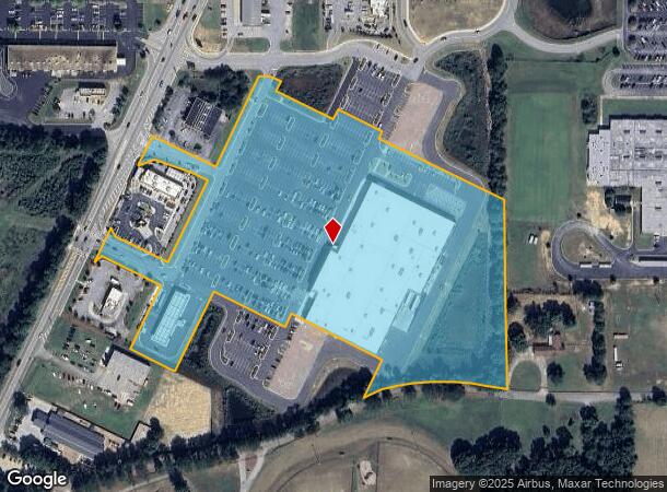
Property Record
2000 Highway 155 N, Mcdonough, GA 30252

NEARBY LISTINGS FOR SALE OR LEASE
-
-
View all Mcdonough listings for sale on LoopNet.com
Property Detail
2000 Highway 155 N
0103-03-019-007
LAND LOT: 27 /LAND DISTRICT: 7
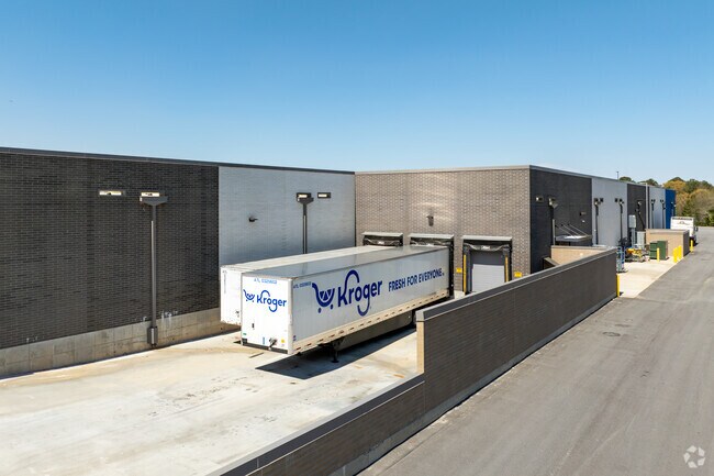
Regionalshoppingcenterormallwithanchorstore
Henry
X
Georgia
13151C0095D
14.88 AC
2025
McDonough/Butts
2025
Atlanta
070208
Atlanta-Sandy Springs-Roswell, GA
367,812 SF
DEMOGRAPHICS near 2000 Highway 155 N
1 Mile
3 Mile
5 Mile
2024 Total Population
1,593
21,522
76,117
2029 Population
1,744
23,487
83,082
Pop Growth 2024-2029
+ 9.48%
+ 9.13%
+ 9.15%
Average Age
38
40
38
2024 Total Households
517
7,292
26,406
HH Growth 2024-2029
+ 9.67%
+ 9.17%
+ 9.22%
Median Household Inc
$96,180
$93,416
$82,538
Avg Household Size
3.00
2.90
2.80
2024 Avg HH Vehicles
2.00
2.00
2.00
Median Home Value
$261,306
$271,024
$269,985
Median Year Built
1997
1998
1999
Nearby Places
Map Layers
Map Styles
 Street
 Aerial
- Restaurants
- Banks
- Shops
- Fitness
- Groceries
PUBLIC TRANSPORTATION
AIRPORT
Hartsfield - Jackson Atlanta International
DRIVE
WALK
Distance
Hartsfield - Jackson Atlanta International
34 min
23.1 mi
Freight Ports
Georgia Ports - Savannah
DRIVE
WALK
Distance
Georgia Ports - Savannah
255 min
226.0 mi
Nearby Properties
Address
Land Use
TOTAL SIZE
Lot Size
Zoning
Address
Land Use
TOTAL SIZE
Lot Size
Zoning
498,160 SF
44.14 AC
M1
Address
Land Use
TOTAL SIZE
Lot Size
Zoning
540,464 SF
86.60 AC
RA
Address
Land Use
TOTAL SIZE
Lot Size
Zoning
68,500 SF
140.42 AC
R2
Address
Land Use
TOTAL SIZE
Lot Size
Zoning
69,524 SF
11.99 AC
RA
Address
Land Use
TOTAL SIZE
Lot Size
Zoning
25,020 SF
169.25 AC
RA
Address
Land Use
TOTAL SIZE
Lot Size
Zoning
89,514 SF
48.76 AC
Address
Land Use
TOTAL SIZE
Lot Size
Zoning
81,800 SF
31.31 AC
RA
Address
Land Use
TOTAL SIZE
Lot Size
Zoning
116,076 SF
4.55 AC
C3
Address
Land Use
TOTAL SIZE
Lot Size
Zoning
109,203 SF
19.50 AC
RA
Address
Land Use
TOTAL SIZE
Lot Size
Zoning
83,281 SF
15.46 AC
M1
Address
Land Use
TOTAL SIZE
Lot Size
Zoning
51,578 SF
5.75 AC
C3
Address
Land Use
TOTAL SIZE
Lot Size
Zoning
1,818 SF
163.82 AC
RA
Address
Land Use
TOTAL SIZE
Lot Size
Zoning
83,262 SF
30.71 AC
RA
Address
Land Use
TOTAL SIZE
Lot Size
Zoning
48,869 SF
26.62 AC
R2
Address
Land Use
TOTAL SIZE
Lot Size
Zoning
28,764 SF
20.11 AC
RA
Address
Land Use
TOTAL SIZE
Lot Size
Zoning
23,288 SF
20 AC
OI
Address
Land Use
TOTAL SIZE
Lot Size
Zoning
11,225 SF
9.44 AC
C3
Address
Land Use
TOTAL SIZE
Lot Size
Zoning
17,541 SF
1.50 AC
C2
Address
Land Use
TOTAL SIZE
Lot Size
Zoning
127,800 SF
6.70 AC
M1
Address
Land Use
TOTAL SIZE
Lot Size
Zoning
17,955 SF
2.23 AC
Address
Land Use
TOTAL SIZE
Lot Size
Zoning
22,750 SF
4.30 AC
C3
Address
Land Use
TOTAL SIZE
Lot Size
Zoning
22,422 SF
3.03 AC
C1
Address
Land Use
TOTAL SIZE
Lot Size
Zoning
9,750 SF
3.17 AC
C1
Address
Land Use
TOTAL SIZE
Lot Size
Zoning
201,875 SF
6.42 AC
M1
Address
Land Use
TOTAL SIZE
Lot Size
Zoning
77,200 SF
3.60 AC
M1
Address
Land Use
TOTAL SIZE
Lot Size
Zoning
899,052 SF
18.20 AC
M1
Address
Land Use
TOTAL SIZE
Lot Size
Zoning
9,954 SF
1.66 AC
C3
Address
Land Use
TOTAL SIZE
Lot Size
Zoning
8,380 SF
1.17 AC
C2
Address
Land Use
TOTAL SIZE
Lot Size
Zoning
72,306 SF
2.58 AC
C1
The World's #1 Commercial Real Estate Marketplace
Connect with us
© 2025 CoStar Group
The information above has been obtained from sources believed reliable. While we do not doubt its accuracy we have not verified it and make no guarantee, warranty or representation about it. It is your responsibility to independently confirm its accuracy and completeness. Any projections, opinions, assumptions, or estimates used are for example only and do not represent the current or future performance of the property. The value of this transaction to you depends on tax and other factors which should be evaluated by your tax, financial, and legal advisors. You and your advisors should conduct a careful, independent investigation of the property to determine to your satisfaction the suitability of the property for your needs.