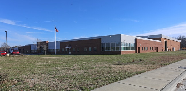
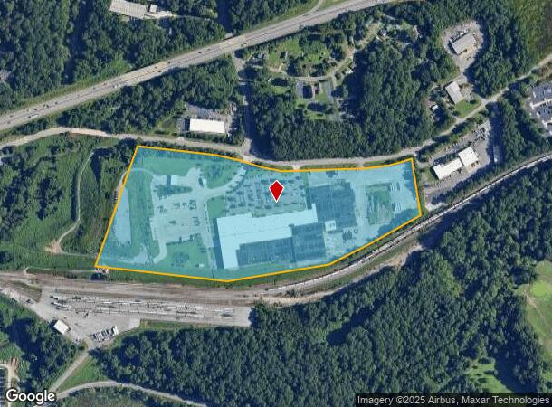
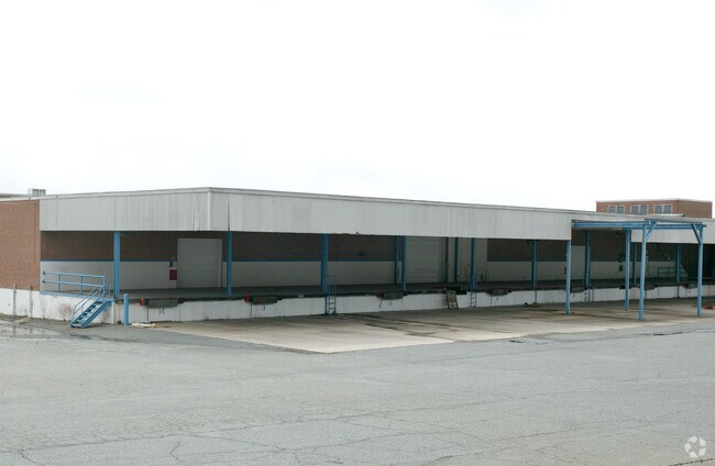
Property Record
2000 Lowery St, Winston Salem, NC 27101
NEARBY LISTINGS FOR SALE OR LEASE
Property Detail
2000 Lowery St
Winston-Salem, NC
W-S Sanitation Div
6845-14-3718
W-S SANITATION DIV. LO:002 BL:6388 BU:1
Commercialnec
Forsyth
X
North Carolina
3710684500J
2
0
35.01 AC
2025
SE Forsyth County
003309
Greensboro/Winston-Salem
1,368 SF
DEMOGRAPHICS near 2000 Lowery St
1 mile
3 mile
5 mile
2024 Total Population
5,236
65,354
142,737
2029 Population
5,504
68,623
149,199
Pop Growth 2024-2029
+ 5.12%
+ 5.00%
+ 4.53%
Average Age
37
36
37
2024 Total Households
1,947
26,127
56,503
HH Growth 2024-2029
+ 5.34%
+ 5.20%
+ 4.71%
Median Household Inc
$32,819
$34,470
$45,405
Avg Household Size
2.40
2.30
2.30
2024 Avg HH Vehicles
1.00
1.00
2.00
Median Home Value
$114,118
$137,816
$173,043
Median Year Built
1970
1968
1972
Nearby Places
Map Layers
Map Styles
 Street
 Aerial
Transit
 Traffic
 Biking
Places
Listings with unknown addresses are not visible on the map
- Restaurants
- Banks
- Shops
- Fitness
- Groceries
PUBLIC TRANSPORTATION
AIRPORT
Piedmont Triad International
Drive
Walk
Distance
Piedmont Triad International
31 min
18.9 mi
Freight Ports
Virginia Port Authority - Richmond
Drive
Walk
Distance
Virginia Port Authority - Richmond
257 min
222.5 mi
Nearby Properties
Address
Land Use
TOTAL SIZE
Lot Size
Zoning
Address
Land Use
TOTAL SIZE
Lot Size
Zoning
368,715 SF
4.11 AC
CI
Address
Land Use
TOTAL SIZE
Lot Size
Zoning
205,729 SF
2.35 AC
CI
Address
Land Use
TOTAL SIZE
Lot Size
Zoning
244,516 SF
4.42 AC
CI
Address
Land Use
TOTAL SIZE
Lot Size
Zoning
297,475 SF
3.06 AC
CI-S
Address
Land Use
TOTAL SIZE
Lot Size
Zoning
315,590 SF
2 AC
CB
Address
Land Use
TOTAL SIZE
Lot Size
Zoning
156,507 SF
NULL
Address
Land Use
TOTAL SIZE
Lot Size
Zoning
121,886 SF
3.92 AC
PB-S
Address
Land Use
TOTAL SIZE
Lot Size
Zoning
100 SF
37.41 AC
C,H
Address
Land Use
TOTAL SIZE
Lot Size
Zoning
202,752 SF
3.43 AC
PB-L
Address
Land Use
TOTAL SIZE
Lot Size
Zoning
352,549 SF
2.30 AC
CB WO
Address
Land Use
TOTAL SIZE
Lot Size
Zoning
140,472 SF
1.33 AC
CB WO
Address
Land Use
TOTAL SIZE
Lot Size
Zoning
153,315 SF
2.07 AC
CI
Address
Land Use
TOTAL SIZE
Lot Size
Zoning
195,551 SF
2.07 AC
CI
Address
Land Use
TOTAL SIZE
Lot Size
Zoning
200 SF
8.16 AC
PB-S
Address
Land Use
TOTAL SIZE
Lot Size
Zoning
154,655 SF
0.76 AC
CI
Address
Land Use
TOTAL SIZE
Lot Size
Zoning
112,000 SF
15.57 AC
IP
Address
Land Use
TOTAL SIZE
Lot Size
Zoning
205,979 SF
1.73 AC
CB WO
Address
Land Use
TOTAL SIZE
Lot Size
Zoning
207,203 SF
4.26 AC
PB
Address
Land Use
TOTAL SIZE
Lot Size
Zoning
70,376 SF
2.86 AC
PB-S
Address
Land Use
TOTAL SIZE
Lot Size
Zoning
106,204 SF
1.13 AC
CI
Address
Land Use
TOTAL SIZE
Lot Size
Zoning
124,134 SF
2.14 AC
CB WO
Address
Land Use
TOTAL SIZE
Lot Size
Zoning
121,925 SF
1.49 AC
GO
Address
Land Use
TOTAL SIZE
Lot Size
Zoning
200,188 SF
4.99 AC
GB-S
Address
Land Use
TOTAL SIZE
Lot Size
Zoning
115,340 SF
2.10 AC
CI
Address
Land Use
TOTAL SIZE
Lot Size
Zoning
56,975 SF
0.26 AC
CB WO
Address
Land Use
TOTAL SIZE
Lot Size
Zoning
62,714 SF
0.55 AC
CB WO
Address
Land Use
TOTAL SIZE
Lot Size
Zoning
177,562 SF
12.59 AC
GO
Address
Land Use
TOTAL SIZE
Lot Size
Zoning
100 SF
119.35 AC
C
Address
Land Use
TOTAL SIZE
Lot Size
Zoning
196,804 SF
2.16 AC
CB
Address
Land Use
TOTAL SIZE
Lot Size
Zoning
46,506 SF
0.55 AC
CB WO
The World's #1 Commercial Real Estate Marketplace
Connect with us
© 2026 CoStar Group
The information above has been obtained from sources believed reliable. While we do not doubt its accuracy we have not verified it and make no guarantee, warranty or representation about it. It is your responsibility to independently confirm its accuracy and completeness. Any projections, opinions, assumptions, or estimates used are for example only and do not represent the current or future performance of the property. The value of this transaction to you depends on tax and other factors which should be evaluated by your tax, financial, and legal advisors. You and your advisors should conduct a careful, independent investigation of the property to determine to your satisfaction the suitability of the property for your needs.