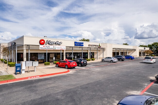
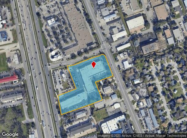
Property Record
2000 N Mays St N, Round Rock, TX 78664
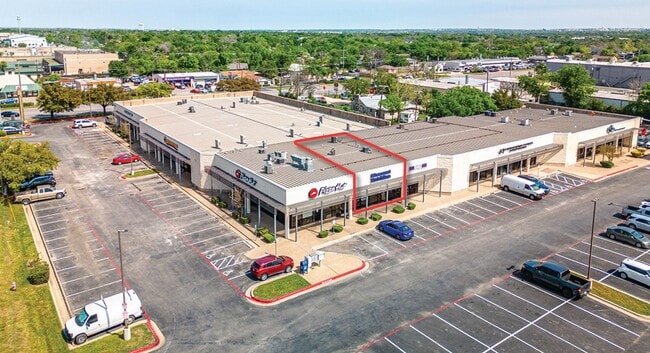
Current Lease Availabilities
Property Detail
2000 N Mays St N
Austin-Round Rock-San Marcos, TX
Triangle Sec 1 Revised (Lt 1 & 2 Blk A A
R604740
S8191 - TRIANGLE SEC 1 REVISED (LT 1 & 2 BLK A AMENDED), BLOCK A, LOT 2A, ACRES 4.9, R086628/COM-REF,R078782/COM-REF
Commercialnec
Williamson
X
Texas
48491C0494F
1a&2a
2024
4.90 AC
2025
Round Rock
021503
Austin
60,016 SF
NEARBY LISTINGS FOR SALE OR LEASE
DEMOGRAPHICS near 2000 N Mays St N
1 mile
3 mile
5 mile
2024 Total Population
9,898
100,081
227,863
2029 Population
12,495
126,310
285,637
Pop Growth 2024-2029
+ 26.24%
+ 26.21%
+ 25.35%
Average Age
35
37
36
2024 Total Households
3,527
36,365
81,536
HH Growth 2024-2029
+ 26.74%
+ 26.74%
+ 25.92%
Median Household Inc
$59,889
$84,879
$100,940
Avg Household Size
2.70
2.70
2.70
2024 Avg HH Vehicles
2.00
2.00
2.00
Median Home Value
$292,246
$348,684
$392,141
Median Year Built
1989
1997
2003
Nearby Places
Map Layers
Map Styles
 Street
 Aerial
Transit
 Traffic
 Biking
Places
Listings with unknown addresses are not visible on the map
- Restaurants
- Banks
- Shops
- Fitness
- Groceries
PUBLIC TRANSPORTATION
AIRPORT
Austin-Bergstrom International
Drive
Walk
Distance
Austin-Bergstrom International
43 min
30.2 mi
Freight Ports
Calhoun Port
Drive
Walk
Distance
Calhoun Port
207 min
178.8 mi
Nearby Properties
Address
Land Use
TOTAL SIZE
Lot Size
Zoning
Address
Land Use
TOTAL SIZE
Lot Size
Zoning
489,460 SF
55.81 AC
PF3
Address
Land Use
TOTAL SIZE
Lot Size
Zoning
543,047 SF
76.14 AC
PUD
Address
Land Use
TOTAL SIZE
Lot Size
Zoning
536,741 SF
80.32 AC
SF2
Address
Land Use
TOTAL SIZE
Lot Size
Zoning
757,866 SF
33.21 AC
Address
Land Use
TOTAL SIZE
Lot Size
Zoning
325,797 SF
36.36 AC
Address
Land Use
TOTAL SIZE
Lot Size
Zoning
345,000 SF
48.61 AC
Address
Land Use
TOTAL SIZE
Lot Size
Zoning
533,151 SF
26.90 AC
PUD
Address
Land Use
TOTAL SIZE
Lot Size
Zoning
445,321 SF
12.52 AC
Address
Land Use
TOTAL SIZE
Lot Size
Zoning
420,181 SF
18.86 AC
Address
Land Use
TOTAL SIZE
Lot Size
Zoning
456,943 SF
66.31 AC
SF2
Address
Land Use
TOTAL SIZE
Lot Size
Zoning
362,216 SF
19.72 AC
Address
Land Use
TOTAL SIZE
Lot Size
Zoning
411,020 SF
29.91 AC
PUD
Address
Land Use
TOTAL SIZE
Lot Size
Zoning
337,685 SF
14.35 AC
Address
Land Use
TOTAL SIZE
Lot Size
Zoning
140,409 SF
17.15 AC
Address
Land Use
TOTAL SIZE
Lot Size
Zoning
330,541 SF
20.90 AC
PUD
Address
Land Use
TOTAL SIZE
Lot Size
Zoning
364,432 SF
20.56 AC
MF
Address
Land Use
TOTAL SIZE
Lot Size
Zoning
203,198 SF
14.04 AC
Address
Land Use
TOTAL SIZE
Lot Size
Zoning
409,875 SF
25.28 AC
MF
Address
Land Use
TOTAL SIZE
Lot Size
Zoning
300,061 SF
19.19 AC
Address
Land Use
TOTAL SIZE
Lot Size
Zoning
295,680 SF
16 AC
MF
Address
Land Use
TOTAL SIZE
Lot Size
Zoning
299,400 SF
15.91 AC
MF
Address
Land Use
TOTAL SIZE
Lot Size
Zoning
330,300 SF
18.58 AC
C1
Address
Land Use
TOTAL SIZE
Lot Size
Zoning
446,815 SF
30.55 AC
Address
Land Use
TOTAL SIZE
Lot Size
Zoning
285,760 SF
15.71 AC
Address
Land Use
TOTAL SIZE
Lot Size
Zoning
375,523 SF
15.43 AC
PUD
Address
Land Use
TOTAL SIZE
Lot Size
Zoning
217,013 SF
20.44 AC
Address
Land Use
TOTAL SIZE
Lot Size
Zoning
236,569 SF
26.86 AC
PUD
Address
Land Use
TOTAL SIZE
Lot Size
Zoning
395,492 SF
7.16 AC
Address
Land Use
TOTAL SIZE
Lot Size
Zoning
326,218 SF
44.54 AC
Address
Land Use
TOTAL SIZE
Lot Size
Zoning
236,046 SF
9.77 AC
The World's #1 Commercial Real Estate Marketplace
Connect with us
© 2026 CoStar Group
The information above has been obtained from sources believed reliable. While we do not doubt its accuracy we have not verified it and make no guarantee, warranty or representation about it. It is your responsibility to independently confirm its accuracy and completeness. Any projections, opinions, assumptions, or estimates used are for example only and do not represent the current or future performance of the property. The value of this transaction to you depends on tax and other factors which should be evaluated by your tax, financial, and legal advisors. You and your advisors should conduct a careful, independent investigation of the property to determine to your satisfaction the suitability of the property for your needs.