Property Record
2000 Ogletown Rd, Newark, DE 19711

Save to a Folder
{{folder.Name}}
{{folder.ListingIds.length}} Properties
{{folder.ListingIds.length}} Property
Create a New Folder
Property Detail
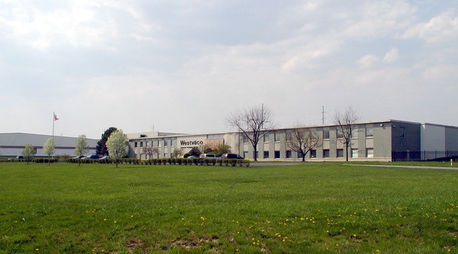
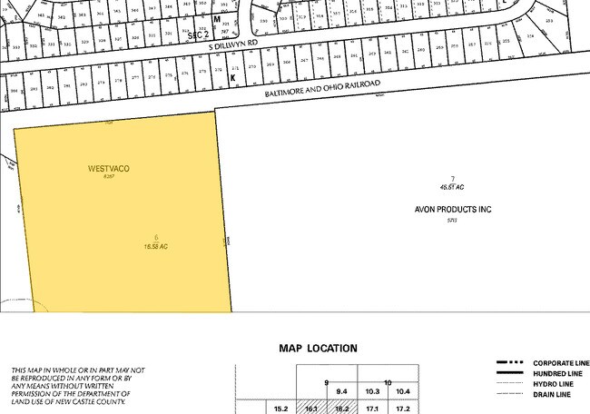
2000 Ogletown Rd
09-016.00-006
BEG AT IRON PIPE FOUND MARKING INTERSECTION OF NLY RIGHT-OF-WAY LIMITSOF STATE R
Storebuilding
New Castle
I
Delaware
B and X Area of moderate flood hazard, usually the area between the limits of the 100-year and 500-year floods.
16.77 AC
2025
New Castle County
2025
Philadelphia
014200
Philadelphia-Camden-Wilmington, PA-NJ-DE-MD
139,990 SF
NEARBY LISTINGS FOR SALE OR LEASE
DEMOGRAPHICS near 2000 Ogletown Rd
1 mile
3 mile
5 mile
2025 Total Population
11,019
84,519
196,113
2030 Population
11,265
88,336
203,057
Pop Growth 2025-2030
+ 2.23%
+ 4.52%
+ 3.54%
Average Age
38
37
39
2025 Total Households
4,226
30,708
75,340
HH Growth 2025-2030
+ 2.51%
+ 4.73%
+ 3.68%
Median Household Inc
$68,331
$76,711
$84,139
Avg Household Size
2.50
2.40
2.40
2025 Avg HH Vehicles
2.00
2.00
2.00
Median Home Value
$293,786
$328,741
$329,958
Median Year Built
1967
1975
1980
Nearby Places
Map Layers
Map Styles
 Street
 Aerial
Layers
 Traffic
 Biking
Places
Listings with unknown addresses are not visible on the map
- Restaurants
- Banks
- Shops
- Fitness
- Groceries
PUBLIC TRANSPORTATION
COMMUTER RAIL
Newark (R2 - Southeastern Pennsylvania Transportation Authority Regional Rail (SEPTA Regional Rail))
Drive
Walk
Distance
Newark (R2 - Southeastern Pennsylvania Transportation Authority Regional Rail (SEPTA Regional Rail))
7 min
3.2 mi
Churchmans Crossing (R2 - Southeastern Pennsylvania Transportation Authority Regional Rail (SEPTA Regional Rail))
Drive
Walk
Distance
Churchmans Crossing (R2 - Southeastern Pennsylvania Transportation Authority Regional Rail (SEPTA Regional Rail))
8 min
3.7 mi
AIRPORT
Philadelphia International
Drive
Walk
Distance
Philadelphia International
45 min
32.5 mi
Freight Ports
Port of Wilmington, RI
Drive
Walk
Distance
Port of Wilmington, RI
20 min
12.4 mi
Nearby Properties
Address
Land Use
TOTAL SIZE
Lot Size
Zoning
Address
Land Use
TOTAL SIZE
Lot Size
Zoning
525,757 SF
189.70 AC
NCPUD
Address
Land Use
TOTAL SIZE
Lot Size
Zoning
354.61 AC
18UN
Address
Land Use
TOTAL SIZE
Lot Size
Zoning
108,170 SF
111.08 AC
18UN
Address
Land Use
TOTAL SIZE
Lot Size
Zoning
169,544 SF
60.86 AC
OR
Address
Land Use
TOTAL SIZE
Lot Size
Zoning
488,637 SF
229.83 AC
NCPUD
Address
Land Use
TOTAL SIZE
Lot Size
Zoning
43,943 SF
8.95 AC
18BB
Address
Land Use
TOTAL SIZE
Lot Size
Zoning
80,834 SF
4.60 AC
18BB
Address
Land Use
TOTAL SIZE
Lot Size
Zoning
92,081 SF
30.99 AC
18RM
Address
Land Use
TOTAL SIZE
Lot Size
Zoning
Address
Land Use
TOTAL SIZE
Lot Size
Zoning
351,528 SF
24.88 AC
NCAP
Address
Land Use
TOTAL SIZE
Lot Size
Zoning
33,790 SF
45.17 AC
S
Address
Land Use
TOTAL SIZE
Lot Size
Zoning
54,907 SF
21.74 AC
18RA
Address
Land Use
TOTAL SIZE
Lot Size
Zoning
560 SF
157.58 AC
18STC
Address
Land Use
TOTAL SIZE
Lot Size
Zoning
57,214 SF
1.10 AC
18BB
Address
Land Use
TOTAL SIZE
Lot Size
Zoning
138,791 SF
15.19 AC
18STC
Address
Land Use
TOTAL SIZE
Lot Size
Zoning
118,400 SF
59.44 AC
S
Address
Land Use
TOTAL SIZE
Lot Size
Zoning
62,498 SF
132.23 AC
I
Address
Land Use
TOTAL SIZE
Lot Size
Zoning
276,191 SF
54.91 AC
BP
Address
Land Use
TOTAL SIZE
Lot Size
Zoning
2,463 SF
5.98 AC
18STC
Address
Land Use
TOTAL SIZE
Lot Size
Zoning
242,811 SF
38.77 AC
CR
Address
Land Use
TOTAL SIZE
Lot Size
Zoning
119,820 SF
19.86 AC
18UN
Address
Land Use
TOTAL SIZE
Lot Size
Zoning
332,800 SF
18.70 AC
NCAP
Address
Land Use
TOTAL SIZE
Lot Size
Zoning
102,955 SF
9.57 AC
I
Address
Land Use
TOTAL SIZE
Lot Size
Zoning
108,553 SF
5.89 AC
18RM
Address
Land Use
TOTAL SIZE
Lot Size
Zoning
225,947 SF
18.68 AC
NCAP
Address
Land Use
TOTAL SIZE
Lot Size
Zoning
Address
Land Use
TOTAL SIZE
Lot Size
Zoning
166,635 SF
50 AC
18STC
Address
Land Use
TOTAL SIZE
Lot Size
Zoning
21,243 SF
154.32 AC
OR
Address
Land Use
TOTAL SIZE
Lot Size
Zoning
1,815 SF
115.74 AC
S
Address
Land Use
TOTAL SIZE
Lot Size
Zoning
396,768 SF
11.96 AC
NCAP
The World's #1 Commercial Real Estate Marketplace
Connect with us
© 2026 CoStar Group
The information above has been obtained from sources believed reliable. While we do not doubt its accuracy we have not verified it and make no guarantee, warranty or representation about it. It is your responsibility to independently confirm its accuracy and completeness. Any projections, opinions, assumptions, or estimates used are for example only and do not represent the current or future performance of the property. The value of this transaction to you depends on tax and other factors which should be evaluated by your tax, financial, and legal advisors. You and your advisors should conduct a careful, independent investigation of the property to determine to your satisfaction the suitability of the property for your needs.