Property Record
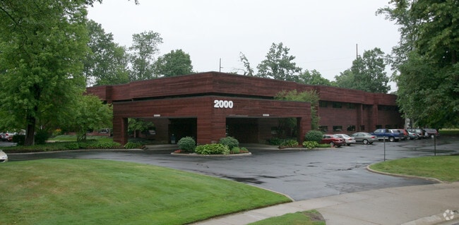
2000 Regency Ct, Toledo, OH 43623


Property Detail
2000 Regency Ct
24-22191
THE REGENCY LOT 2 TRI PCE MEAS 10 FT N & E LINES 14.05 FT SWLINE EXC PT IN RD
Medicalbuilding
Lucas
10-CO
Ohio
B and X Area of moderate flood hazard, usually the area between the limits of the 100-year and 500-year floods.
2
0
3.79 AC
2025
West/Sylvania
008303
Toledo
52,429 SF
Toledo, OH
NEARBY LISTINGS FOR SALE OR LEASE
DEMOGRAPHICS near 2000 Regency Ct
1 mile
3 mile
5 mile
2025 Total Population
9,205
73,062
193,295
2030 Population
8,925
71,556
191,036
Pop Growth 2025-2030
(3.04%)
(2.06%)
(1.17%)
Average Age
43
41
40
2025 Total Households
4,013
32,226
82,332
HH Growth 2025-2030
(3.09%)
(2.05%)
(1.12%)
Median Household Inc
$73,419
$72,416
$66,330
Avg Household Size
2.30
2.20
2.20
2025 Avg HH Vehicles
2.00
2.00
2.00
Median Home Value
$183,485
$175,470
$172,763
Median Year Built
1965
1961
1963
Nearby Places
Map Layers
Map Styles
 Street
 Aerial
Transit
 Traffic
 Biking
Places
Listings with unknown addresses are not visible on the map
- Restaurants
- Banks
- Shops
- Fitness
- Groceries
PUBLIC TRANSPORTATION
COMMUTER RAIL
Drive
Walk
Distance
15 min
8.0 mi
AIRPORT
Eugene F Kranz Toledo Express
Drive
Walk
Distance
Eugene F Kranz Toledo Express
36 min
19.5 mi
Detroit Metro Wayne County
Drive
Walk
Distance
Detroit Metro Wayne County
65 min
48.4 mi
SALE & LEASE HISTORY
LISTING DATE
SALE/LEASE

Jan 04, 2023
For Lease
Nearby Properties
Address
Land Use
TOTAL SIZE
Lot Size
Zoning
Address
Land Use
TOTAL SIZE
Lot Size
Zoning
607,717 SF
7.39 AC
31-R3
Address
Land Use
TOTAL SIZE
Lot Size
Zoning
448,269 SF
29.52 AC
10-IC
Address
Land Use
TOTAL SIZE
Lot Size
Zoning
253,662 SF
16.59 AC
10-MX
Address
Land Use
TOTAL SIZE
Lot Size
Zoning
15.79 AC
31-B4
Address
Land Use
TOTAL SIZE
Lot Size
Zoning
312,089 SF
6.34 AC
31-B5
Address
Land Use
TOTAL SIZE
Lot Size
Zoning
7.71 AC
10-CRSO
Address
Land Use
TOTAL SIZE
Lot Size
Zoning
12.52 AC
10-CRSO
Address
Land Use
TOTAL SIZE
Lot Size
Zoning
293,770 SF
13.95 AC
10-RS6
Address
Land Use
TOTAL SIZE
Lot Size
Zoning
260,875 SF
9.91 AC
20-R5
Address
Land Use
TOTAL SIZE
Lot Size
Zoning
90,113 SF
11.83 AC
10-RS6
Address
Land Use
TOTAL SIZE
Lot Size
Zoning
166,837 SF
23.82 AC
10-MX
Address
Land Use
TOTAL SIZE
Lot Size
Zoning
208,092 SF
12.49 AC
10-CR
Address
Land Use
TOTAL SIZE
Lot Size
Zoning
87,071 SF
8.10 AC
10-CRSO
Address
Land Use
TOTAL SIZE
Lot Size
Zoning
141,643 SF
14.31 AC
10-RS9
Address
Land Use
TOTAL SIZE
Lot Size
Zoning
222,493 SF
29.88 AC
10-IC
Address
Land Use
TOTAL SIZE
Lot Size
Zoning
49,960 SF
8.33 AC
10-CO
Address
Land Use
TOTAL SIZE
Lot Size
Zoning
49,960 SF
8.33 AC
10-CO
Address
Land Use
TOTAL SIZE
Lot Size
Zoning
51,129 SF
460.05 AC
20-S1
Address
Land Use
TOTAL SIZE
Lot Size
Zoning
154,003 SF
14 AC
10-MX
Address
Land Use
TOTAL SIZE
Lot Size
Zoning
169,580 SF
8.98 AC
20-C2
Address
Land Use
TOTAL SIZE
Lot Size
Zoning
67,713 SF
10.24 AC
20-C2
Address
Land Use
TOTAL SIZE
Lot Size
Zoning
174,890 SF
19.86 AC
31-R3
Address
Land Use
TOTAL SIZE
Lot Size
Zoning
203,129 SF
10 AC
10-RS9
Address
Land Use
TOTAL SIZE
Lot Size
Zoning
157,086 SF
13.24 AC
10-CRSO
Address
Land Use
TOTAL SIZE
Lot Size
Zoning
161,884 SF
3.09 AC
10-RM36
Address
Land Use
TOTAL SIZE
Lot Size
Zoning
135,978 SF
14.01 AC
31-B2
Address
Land Use
TOTAL SIZE
Lot Size
Zoning
123,985 SF
9.74 AC
10-MX
Address
Land Use
TOTAL SIZE
Lot Size
Zoning
84,485 SF
8.41 AC
20-C2
Address
Land Use
TOTAL SIZE
Lot Size
Zoning
214,400 SF
13.07 AC
20-C2
The World's #1 Commercial Real Estate Marketplace
Connect with us
© 2026 CoStar Group
The information above has been obtained from sources believed reliable. While we do not doubt its accuracy we have not verified it and make no guarantee, warranty or representation about it. It is your responsibility to independently confirm its accuracy and completeness. Any projections, opinions, assumptions, or estimates used are for example only and do not represent the current or future performance of the property. The value of this transaction to you depends on tax and other factors which should be evaluated by your tax, financial, and legal advisors. You and your advisors should conduct a careful, independent investigation of the property to determine to your satisfaction the suitability of the property for your needs.