Property Record
2000 S Padre Island Dr, Corpus Christi, TX 78416
NEARBY LISTINGS FOR SALE OR LEASE
-
-
View all Corpus Christi listings for sale on LoopNet.com
Property Detail
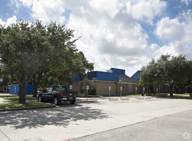
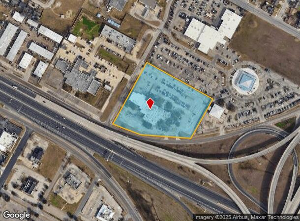
2000 S Padre Island Dr
Corpus Christi, TX
Teachers Credit Union
200041507
TEACHERS CREDIT UNION LT 1 BLK 1
Commercialnec
Nueces
X
Texas
48355C0510G
1
2024
5.19 AC
2025
West Side
001801
Corpus Christi
27,859 SF
DEMOGRAPHICS near 2000 S Padre Island Dr
1 Mile
3 Mile
5 Mile
2024 Total Population
8,209
83,150
165,862
2029 Population
8,027
81,839
164,087
Pop Growth 2024-2029
(2.22%)
(1.58%)
(1.07%)
Average Age
38
38
39
2024 Total Households
2,800
29,655
61,765
HH Growth 2024-2029
(2.39%)
(1.62%)
(1.10%)
Median Household Inc
$41,870
$44,594
$48,243
Avg Household Size
2.80
2.70
2.60
2024 Avg HH Vehicles
2.00
2.00
2.00
Median Home Value
$83,977
$108,284
$135,624
Median Year Built
1958
1962
1969
Nearby Places
Map Layers
Map Styles
 Street
 Aerial
- Restaurants
- Banks
- Shops
- Fitness
- Groceries
PUBLIC TRANSPORTATION
AIRPORT
Corpus Christi International
DRIVE
WALK
Distance
Corpus Christi International
12 min
6.9 mi
SALE & LEASE HISTORY
LISTING DATE
SALE/LEASE

Feb 05, 2019
For Sale
Nearby Properties
Address
Land Use
TOTAL SIZE
Lot Size
Zoning
Address
Land Use
TOTAL SIZE
Lot Size
Zoning
567,638 SF
18.37 AC
B4
Address
Land Use
TOTAL SIZE
Lot Size
Zoning
419,479 SF
32.65 AC
Address
Land Use
TOTAL SIZE
Lot Size
Zoning
382,448 SF
14.98 AC
Address
Land Use
TOTAL SIZE
Lot Size
Zoning
1 SF
62.73 AC
III
Address
Land Use
TOTAL SIZE
Lot Size
Zoning
176,076 SF
19.84 AC
R1B
Address
Land Use
TOTAL SIZE
Lot Size
Zoning
251,402 SF
7.17 AC
Address
Land Use
TOTAL SIZE
Lot Size
Zoning
278,919 SF
39.27 AC
R1B
Address
Land Use
TOTAL SIZE
Lot Size
Zoning
1 SF
40.02 AC
R1B
Address
Land Use
TOTAL SIZE
Lot Size
Zoning
74,247 SF
6.39 AC
Address
Land Use
TOTAL SIZE
Lot Size
Zoning
124,257 SF
7.63 AC
Address
Land Use
TOTAL SIZE
Lot Size
Zoning
65,301 SF
7.37 AC
B-4
Address
Land Use
TOTAL SIZE
Lot Size
Zoning
85,871 SF
18.68 AC
R1B
Address
Land Use
TOTAL SIZE
Lot Size
Zoning
11,109 SF
76.58 AC
R1B
Address
Land Use
TOTAL SIZE
Lot Size
Zoning
89,537 SF
11.35 AC
R1B
Address
Land Use
TOTAL SIZE
Lot Size
Zoning
83,835 SF
19.14 AC
Address
Land Use
TOTAL SIZE
Lot Size
Zoning
101,912 SF
13.89 AC
I-2
Address
Land Use
TOTAL SIZE
Lot Size
Zoning
74,261 SF
4.44 AC
R1B
Address
Land Use
TOTAL SIZE
Lot Size
Zoning
105.49 AC
R1B
Address
Land Use
TOTAL SIZE
Lot Size
Zoning
13,773 SF
28.82 AC
R1B
Address
Land Use
TOTAL SIZE
Lot Size
Zoning
114,121 SF
2.64 AC
B-4
Address
Land Use
TOTAL SIZE
Lot Size
Zoning
42,984 SF
5.20 AC
Address
Land Use
TOTAL SIZE
Lot Size
Zoning
186,106 SF
6.54 AC
B1
Address
Land Use
TOTAL SIZE
Lot Size
Zoning
94,600 SF
9.29 AC
R2
Address
Land Use
TOTAL SIZE
Lot Size
Zoning
140,058 SF
90.04 AC
I2
Address
Land Use
TOTAL SIZE
Lot Size
Zoning
95,658 SF
21.87 AC
I2
Address
Land Use
TOTAL SIZE
Lot Size
Zoning
60,934 SF
12.20 AC
R1B
Address
Land Use
TOTAL SIZE
Lot Size
Zoning
83,499 SF
5.38 AC
III
Address
Land Use
TOTAL SIZE
Lot Size
Zoning
95,860 SF
10.80 AC
R1B
Address
Land Use
TOTAL SIZE
Lot Size
Zoning
25,998 SF
31.72 AC
R1B
Address
Land Use
TOTAL SIZE
Lot Size
Zoning
73,559 SF
11.05 AC
R1B
The World's #1 Commercial Real Estate Marketplace
Connect with us
© 2025 CoStar Group
The information above has been obtained from sources believed reliable. While we do not doubt its accuracy we have not verified it and make no guarantee, warranty or representation about it. It is your responsibility to independently confirm its accuracy and completeness. Any projections, opinions, assumptions, or estimates used are for example only and do not represent the current or future performance of the property. The value of this transaction to you depends on tax and other factors which should be evaluated by your tax, financial, and legal advisors. You and your advisors should conduct a careful, independent investigation of the property to determine to your satisfaction the suitability of the property for your needs.