Property Record
2000 Spring Arbor Rd, Jackson, MI 49203


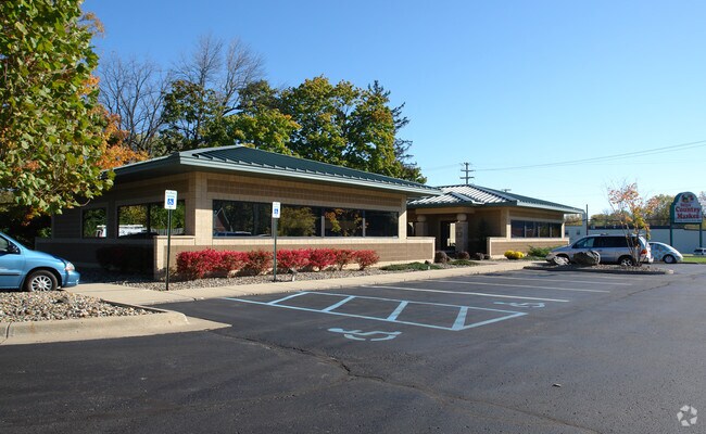
Property Detail
2000 Spring Arbor Rd
000-13-04-301-039-00
BEG AT THE INTERSECTION OF THE E LN OF 21ST ST EXTENDED S WITH THE S LN OF BROOKLINE, A RECORDED PLAT, TH S 73%50'E 700 FT
Officebuilding
Jackson
O-1
Michigan
B and X Area of moderate flood hazard, usually the area between the limits of the 100-year and 500-year floods.
2.75 AC
2024
Jackson County
2025
West Michigan
005301
Jackson, MI
12,208 SF
NEARBY LISTINGS FOR SALE OR LEASE
DEMOGRAPHICS near 2000 Spring Arbor Rd
1 mile
3 mile
5 mile
2025 Total Population
7,766
49,354
74,971
2030 Population
7,691
49,218
74,663
Pop Growth 2025-2030
(0.97%)
(0.28%)
(0.41%)
Average Age
40
40
40
2025 Total Households
3,353
21,163
31,369
HH Growth 2025-2030
(1.01%)
(0.27%)
(0.41%)
Median Household Inc
$60,266
$47,398
$52,939
Avg Household Size
2.30
2.20
2.30
2025 Avg HH Vehicles
2.00
2.00
2.00
Median Home Value
$162,045
$149,425
$157,951
Median Year Built
1949
1954
1957
Nearby Places
Map Layers
Map Styles
 Street
 Aerial
Transit
 Traffic
 Biking
Places
Listings with unknown addresses are not visible on the map
- Restaurants
- Banks
- Shops
- Fitness
- Groceries
PUBLIC TRANSPORTATION
COMMUTER RAIL
Drive
Walk
Distance
5 min
2.6 mi
Freight Ports
Drive
Walk
Distance
118 min
97.3 mi
Nearby Properties
Address
Land Use
TOTAL SIZE
Lot Size
Zoning
Address
Land Use
TOTAL SIZE
Lot Size
Zoning
392,155 SF
7.01 AC
C-3
Address
Land Use
TOTAL SIZE
Lot Size
Zoning
121,532 SF
29.94 AC
PC-1
Address
Land Use
TOTAL SIZE
Lot Size
Zoning
398,449 SF
41.51 AC
PR-1
Address
Land Use
TOTAL SIZE
Lot Size
Zoning
240,148 SF
30.64 AC
PC-1
Address
Land Use
TOTAL SIZE
Lot Size
Zoning
415,004 SF
19.97 AC
PB
Address
Land Use
TOTAL SIZE
Lot Size
Zoning
224,803 SF
22.59 AC
RM-1
Address
Land Use
TOTAL SIZE
Lot Size
Zoning
401,234 SF
23.40 AC
I-2
Address
Land Use
TOTAL SIZE
Lot Size
Zoning
64,257 SF
1.90 AC
R-4
Address
Land Use
TOTAL SIZE
Lot Size
Zoning
187,264 SF
7.10 AC
R-4
Address
Land Use
TOTAL SIZE
Lot Size
Zoning
189,680 SF
6.90 AC
R-4
Address
Land Use
TOTAL SIZE
Lot Size
Zoning
202,757 SF
13 AC
PC-1
Address
Land Use
TOTAL SIZE
Lot Size
Zoning
74,254 SF
12.64 AC
I-2
Address
Land Use
TOTAL SIZE
Lot Size
Zoning
84,489 SF
55.50 AC
RM-1
Address
Land Use
TOTAL SIZE
Lot Size
Zoning
125,393 SF
3.94 AC
C-2
Address
Land Use
TOTAL SIZE
Lot Size
Zoning
91,108 SF
5.42 AC
C-2
Address
Land Use
TOTAL SIZE
Lot Size
Zoning
145,152 SF
41.45 AC
RM-1
Address
Land Use
TOTAL SIZE
Lot Size
Zoning
84,084 SF
6.50 AC
PB
Address
Land Use
TOTAL SIZE
Lot Size
Zoning
242,708 SF
29.44 AC
PC-1
Address
Land Use
TOTAL SIZE
Lot Size
Zoning
110,011 SF
12.50 AC
Address
Land Use
TOTAL SIZE
Lot Size
Zoning
207,420 SF
15.10 AC
RM-1
Address
Land Use
TOTAL SIZE
Lot Size
Zoning
217,324 SF
40.24 AC
I-2
Address
Land Use
TOTAL SIZE
Lot Size
Zoning
136,221 SF
8.04 AC
R-3
Address
Land Use
TOTAL SIZE
Lot Size
Zoning
136,221 SF
6.78 AC
R-3
Address
Land Use
TOTAL SIZE
Lot Size
Zoning
112,571 SF
9.35 AC
C-4
Address
Land Use
TOTAL SIZE
Lot Size
Zoning
137,313 SF
23.30 AC
C-3
Address
Land Use
TOTAL SIZE
Lot Size
Zoning
159,432 SF
31.90 AC
RM-1
Address
Land Use
TOTAL SIZE
Lot Size
Zoning
67,146 SF
0.80 AC
C-3
Address
Land Use
TOTAL SIZE
Lot Size
Zoning
111,312 SF
3.27 AC
R-2
Address
Land Use
TOTAL SIZE
Lot Size
Zoning
35,908 SF
6.60 AC
R-4
Address
Land Use
TOTAL SIZE
Lot Size
Zoning
98,560 SF
13.35 AC
RM-1
The World's #1 Commercial Real Estate Marketplace
Connect with us
© 2026 CoStar Group
The information above has been obtained from sources believed reliable. While we do not doubt its accuracy we have not verified it and make no guarantee, warranty or representation about it. It is your responsibility to independently confirm its accuracy and completeness. Any projections, opinions, assumptions, or estimates used are for example only and do not represent the current or future performance of the property. The value of this transaction to you depends on tax and other factors which should be evaluated by your tax, financial, and legal advisors. You and your advisors should conduct a careful, independent investigation of the property to determine to your satisfaction the suitability of the property for your needs.