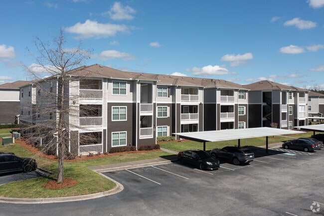
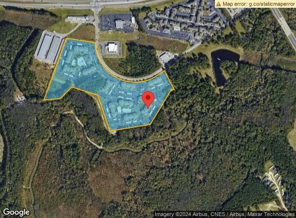
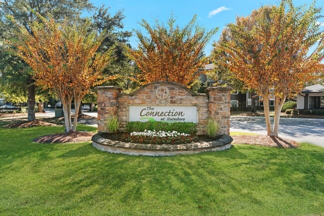
Property Record
2000 Stambuk Ln, Statesboro, GA 30458
NEARBY LISTINGS FOR SALE OR LEASE
Property Detail
2000 Stambuk Ln
MS63000026-016
22.959 AC /FAIRFIELD/2000 STAMBUK LN
Clubslodgesprofessionalassociations
Bulloch
A
Georgia
13031C0220D
22.96 AC
2024
Georgia South Area
2025
Other Market Areas
110406
Statesboro, GA
7,063 SF
DEMOGRAPHICS near 2000 Stambuk Ln
1 Mile
3 Mile
5 Mile
2024 Total Population
7,275
29,630
51,042
2029 Population
7,795
31,947
55,674
Pop Growth 2024-2029
+ 7.15%
+ 7.82%
+ 9.07%
Average Age
26
29
33
2024 Total Households
2,839
10,471
18,771
HH Growth 2024-2029
+ 7.54%
+ 8.56%
+ 9.89%
Median Household Inc
$38,229
$47,904
$51,813
Avg Household Size
2.40
2.30
2.40
2024 Avg HH Vehicles
2.00
2.00
2.00
Median Home Value
$164,900
$189,744
$193,862
Median Year Built
1995
1993
1992
Nearby Places
Map Layers
Map Styles
 Street
 Aerial
- Restaurants
- Banks
- Shops
- Fitness
- Groceries
Nearby Properties
Address
Land Use
TOTAL SIZE
Lot Size
Zoning
Address
Land Use
TOTAL SIZE
Lot Size
Zoning
612.82 AC
EXPT
Address
Land Use
TOTAL SIZE
Lot Size
Zoning
15,334 SF
1.67 AC
CR
Address
Land Use
TOTAL SIZE
Lot Size
Zoning
250,037 SF
30.67 AC
O
Address
Land Use
TOTAL SIZE
Lot Size
Zoning
9,870 SF
46.47 AC
CR/R4
Address
Land Use
TOTAL SIZE
Lot Size
Zoning
10,228 SF
24.06 AC
R4
Address
Land Use
TOTAL SIZE
Lot Size
Zoning
11,490 SF
10.01 AC
R4
Address
Land Use
TOTAL SIZE
Lot Size
Zoning
7,470 SF
39.71 AC
CR
Address
Land Use
TOTAL SIZE
Lot Size
Zoning
5.54 AC
EXPT
Address
Land Use
TOTAL SIZE
Lot Size
Zoning
41.09 AC
R3/R15
Address
Land Use
TOTAL SIZE
Lot Size
Zoning
146,137 SF
17.78 AC
CR
Address
Land Use
TOTAL SIZE
Lot Size
Zoning
55 AC
EXPT
Address
Land Use
TOTAL SIZE
Lot Size
Zoning
3,659 SF
38.60 AC
R40
Address
Land Use
TOTAL SIZE
Lot Size
Zoning
37,918 SF
9.93 AC
R4
Address
Land Use
TOTAL SIZE
Lot Size
Zoning
8,824 SF
29.25 AC
PUD/R4
Address
Land Use
TOTAL SIZE
Lot Size
Zoning
8,394 SF
14.34 AC
R4/CR
Address
Land Use
TOTAL SIZE
Lot Size
Zoning
3,951 SF
20.19 AC
CR
Address
Land Use
TOTAL SIZE
Lot Size
Zoning
54,062 SF
2.20 AC
CR
Address
Land Use
TOTAL SIZE
Lot Size
Zoning
3,552 SF
16.42 AC
PUD/R4/CR
Address
Land Use
TOTAL SIZE
Lot Size
Zoning
22,392 SF
13.97 AC
R4
Address
Land Use
TOTAL SIZE
Lot Size
Zoning
60,537 SF
8.76 AC
CR
Address
Land Use
TOTAL SIZE
Lot Size
Zoning
4,450 SF
26.60 AC
R4
Address
Land Use
TOTAL SIZE
Lot Size
Zoning
58,520 SF
2.44 AC
CR
Address
Land Use
TOTAL SIZE
Lot Size
Zoning
61,539 SF
2.50 AC
CR
Address
Land Use
TOTAL SIZE
Lot Size
Zoning
58,176 SF
2.10 AC
HOC
Address
Land Use
TOTAL SIZE
Lot Size
Zoning
4,969 SF
13.52 AC
PUD/R4
Address
Land Use
TOTAL SIZE
Lot Size
Zoning
12,010 SF
21.14 AC
HC
Address
Land Use
TOTAL SIZE
Lot Size
Zoning
21.05 AC
PUD/R4
Address
Land Use
TOTAL SIZE
Lot Size
Zoning
31.73 AC
LI
Address
Land Use
TOTAL SIZE
Lot Size
Zoning
4,622 SF
17 AC
R4/CR
The World's #1 Commercial Real Estate Marketplace
Connect with us
© 2026 CoStar Group
The information above has been obtained from sources believed reliable. While we do not doubt its accuracy we have not verified it and make no guarantee, warranty or representation about it. It is your responsibility to independently confirm its accuracy and completeness. Any projections, opinions, assumptions, or estimates used are for example only and do not represent the current or future performance of the property. The value of this transaction to you depends on tax and other factors which should be evaluated by your tax, financial, and legal advisors. You and your advisors should conduct a careful, independent investigation of the property to determine to your satisfaction the suitability of the property for your needs.