Property Record
2000 Tom Williams Way, Irondale, AL 35210

NEARBY LISTINGS FOR SALE OR LEASE
-
-
View all Irondale listings for sale on LoopNet.com
Property Detail
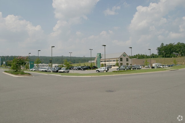
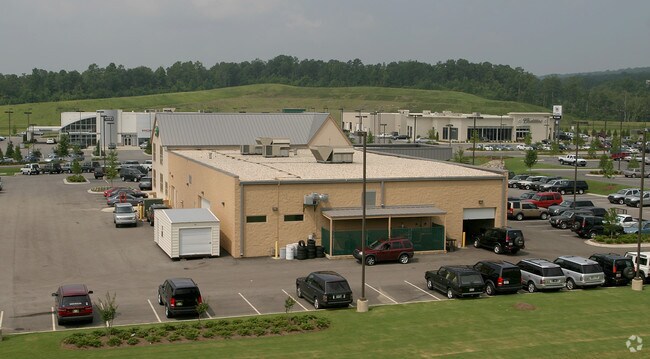
2000 Tom Williams Way
Birmingham-Hoover, AL
Grants Mill Auto Mall
24-00-29-4-000-022.001
LOT 1 GRANTS MILL AUTO MALL 211/1 211/38
Vehiclerentalsvehiclesales
Jefferson
X
Alabama
01073C0418H
1
2023
15.48 AC
2024
Trussville
010807
Birmingham
158,161 SF
DEMOGRAPHICS near 2000 Tom Williams Way
1 Mile
3 Mile
5 Mile
2024 Total Population
1,104
14,583
59,445
2029 Population
1,074
14,143
58,350
Pop Growth 2024-2029
(2.72%)
(3.02%)
(1.84%)
Average Age
46
41
40
2024 Total Households
463
5,715
23,679
HH Growth 2024-2029
(2.81%)
(2.99%)
(1.99%)
Median Household Inc
$87,335
$87,966
$68,231
Avg Household Size
2.30
2.50
2.40
2024 Avg HH Vehicles
2.00
2.00
2.00
Median Home Value
$263,499
$287,055
$265,874
Median Year Built
1980
1979
1971
Nearby Places
Map Layers
Map Styles
 Street
 Aerial
- Restaurants
- Banks
- Shops
- Fitness
- Groceries
PUBLIC TRANSPORTATION
AIRPORT
Birmingham-Shuttlesworth International
DRIVE
WALK
Distance
Birmingham-Shuttlesworth International
16 min
8.3 mi
Freight Ports
Port of Mobile
DRIVE
WALK
Distance
Port of Mobile
282 min
258.3 mi
Nearby Properties
Address
Land Use
TOTAL SIZE
Lot Size
Zoning
Address
Land Use
TOTAL SIZE
Lot Size
Zoning
174,247 SF
46.70 AC
INST
Address
Land Use
TOTAL SIZE
Lot Size
Zoning
146,331 SF
161 AC
I3S&
Address
Land Use
TOTAL SIZE
Lot Size
Zoning
125,324 SF
53 AC
INST
Address
Land Use
TOTAL SIZE
Lot Size
Zoning
137,168 SF
63 AC
A1
Address
Land Use
TOTAL SIZE
Lot Size
Zoning
168,744 SF
8.46 AC
I1
Address
Land Use
TOTAL SIZE
Lot Size
Zoning
8.10 AC
QR6
Address
Land Use
TOTAL SIZE
Lot Size
Zoning
223,365 SF
15 AC
I1
Address
Land Use
TOTAL SIZE
Lot Size
Zoning
43,566 SF
18.99 AC
C1
Address
Land Use
TOTAL SIZE
Lot Size
Zoning
52,416 SF
7 AC
A1
Address
Land Use
TOTAL SIZE
Lot Size
Zoning
113,014 SF
8 AC
I1
Address
Land Use
TOTAL SIZE
Lot Size
Zoning
104,000 SF
7.66 AC
I1
Address
Land Use
TOTAL SIZE
Lot Size
Zoning
47,720 SF
5.21 AC
QB2
Address
Land Use
TOTAL SIZE
Lot Size
Zoning
129,706 SF
120 AC
INST
Address
Land Use
TOTAL SIZE
Lot Size
Zoning
64,859 SF
105 AC
INST
Address
Land Use
TOTAL SIZE
Lot Size
Zoning
97,021 SF
17.50 AC
R1
Address
Land Use
TOTAL SIZE
Lot Size
Zoning
63,798 SF
4.18 AC
I1
Address
Land Use
TOTAL SIZE
Lot Size
Zoning
119,300 SF
7.72 AC
I1
Address
Land Use
TOTAL SIZE
Lot Size
Zoning
89,526 SF
7.30 AC
C1&O
Address
Land Use
TOTAL SIZE
Lot Size
Zoning
14,432 SF
38.50 AC
I1
Address
Land Use
TOTAL SIZE
Lot Size
Zoning
96,670 SF
5.50 AC
C1PO
Address
Land Use
TOTAL SIZE
Lot Size
Zoning
31,103 SF
2 AC
C-2
Address
Land Use
TOTAL SIZE
Lot Size
Zoning
76,304 SF
12 AC
R-A
Address
Land Use
TOTAL SIZE
Lot Size
Zoning
40,759 SF
5.40 AC
C-1
Address
Land Use
TOTAL SIZE
Lot Size
Zoning
28,068 SF
4.65 AC
C1
Address
Land Use
TOTAL SIZE
Lot Size
Zoning
22,866 SF
4.41 AC
A1
Address
Land Use
TOTAL SIZE
Lot Size
Zoning
228,928 SF
25 AC
C-1
Address
Land Use
TOTAL SIZE
Lot Size
Zoning
137,210 SF
14 AC
C-1
Address
Land Use
TOTAL SIZE
Lot Size
Zoning
31,128 SF
6.32 AC
C1
Address
Land Use
TOTAL SIZE
Lot Size
Zoning
26,842 SF
48 AC
R7PU
The World's #1 Commercial Real Estate Marketplace
Connect with us
© 2026 CoStar Group
The information above has been obtained from sources believed reliable. While we do not doubt its accuracy we have not verified it and make no guarantee, warranty or representation about it. It is your responsibility to independently confirm its accuracy and completeness. Any projections, opinions, assumptions, or estimates used are for example only and do not represent the current or future performance of the property. The value of this transaction to you depends on tax and other factors which should be evaluated by your tax, financial, and legal advisors. You and your advisors should conduct a careful, independent investigation of the property to determine to your satisfaction the suitability of the property for your needs.