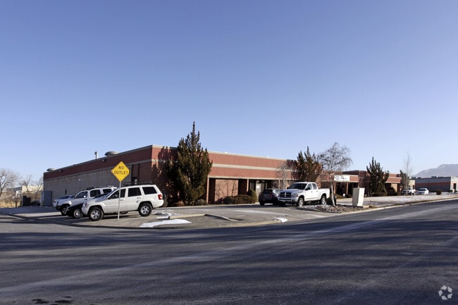
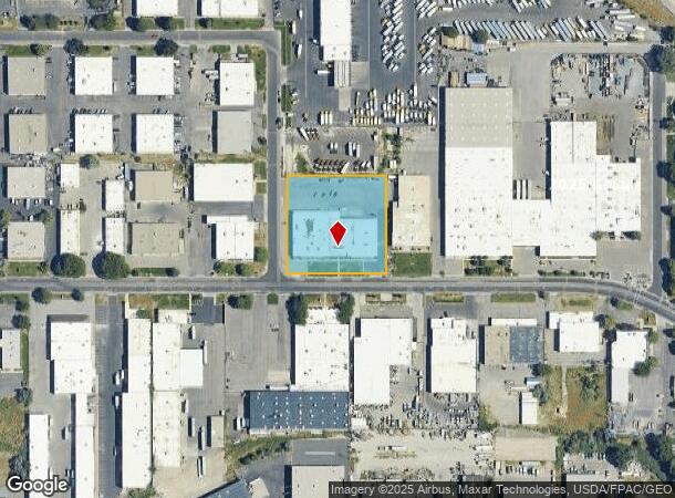
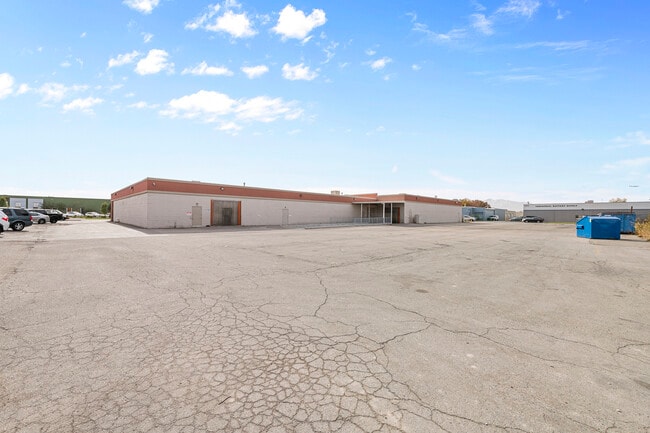
Property Record
2000 W 2300 S, West Valley City, UT 84119
Current Lease Availabilities
NEARBY LISTINGS FOR SALE OR LEASE
Property Detail
2000 W 2300 S
15-22-102-014-0000
BEG N 0^0235 E 1083 FT & W 1332.67 FT FR CEN OF SEC 22, T 1S, R 1W, S L M; W 267.12 FT; N 261 FT; E 267.12 FT; S 261 FT TO BEG. 1.6 AC. 5464-2747 5859-2884 7705-2842 08336-2708
Lightindustrial
Salt Lake
X
Utah
49035C0280E
1.60 AC
2024
West Valley
2025
Salt Lake City
113312
Salt Lake City, UT
24,340 SF
DEMOGRAPHICS near 2000 W 2300 S
1 Mile
3 Mile
5 Mile
2024 Total Population
4,843
88,114
336,554
2029 Population
4,838
88,590
342,000
Pop Growth 2024-2029
(0.10%)
+ 0.54%
+ 1.62%
Average Age
34
35
36
2024 Total Households
1,452
29,105
130,383
HH Growth 2024-2029
(0.14%)
+ 0.74%
+ 1.98%
Median Household Inc
$54,736
$56,386
$61,746
Avg Household Size
3.10
2.80
2.40
2024 Avg HH Vehicles
2.00
2.00
2.00
Median Home Value
$220,995
$302,738
$365,701
Median Year Built
1979
1981
1978
Nearby Places
- Restaurants
- Banks
- Shops
- Fitness
- Groceries
PUBLIC TRANSPORTATION
TRANSIT/SUBWAY
Redwood Junction Station (Green Line - Utah Transit Authority (UTA))
DRIVE
WALK
Distance
Redwood Junction Station (Green Line - Utah Transit Authority (UTA))
3 min
19 min
1.0 mi
COMMUTER RAIL
North Temple Station (FrontRunner - Utah Transit Authority (UTA))
DRIVE
WALK
Distance
North Temple Station (FrontRunner - Utah Transit Authority (UTA))
12 min
6.2 mi
Warm Springs Relief Point (FrontRunner - Utah Transit Authority (UTA))
DRIVE
WALK
Distance
Warm Springs Relief Point (FrontRunner - Utah Transit Authority (UTA))
13 min
7.6 mi
AIRPORT
Salt Lake City International
DRIVE
WALK
Distance
Salt Lake City International
11 min
7.1 mi
Freight Ports
Port of Stockton
DRIVE
WALK
Distance
Port of Stockton
711 min
693.7 mi
Nearby Properties
Address
Land Use
TOTAL SIZE
Lot Size
Zoning
Address
Land Use
TOTAL SIZE
Lot Size
Zoning
488,509 SF
36.03 AC
FLEX
Address
Land Use
TOTAL SIZE
Lot Size
Zoning
828,269 SF
9.06 AC
RM
Address
Land Use
TOTAL SIZE
Lot Size
Zoning
673,062 SF
15.84 AC
RM
Address
Land Use
TOTAL SIZE
Lot Size
Zoning
185,436 SF
25.23 AC
RM
Address
Land Use
TOTAL SIZE
Lot Size
Zoning
95,854 SF
15.42 AC
CC
Address
Land Use
TOTAL SIZE
Lot Size
Zoning
322,076 SF
16.32 AC
PL
Address
Land Use
TOTAL SIZE
Lot Size
Zoning
195,790 SF
14.32 AC
RM
Address
Land Use
TOTAL SIZE
Lot Size
Zoning
76,096 SF
17.30 AC
RM
Address
Land Use
TOTAL SIZE
Lot Size
Zoning
84,870 SF
9.76 AC
MPMU
Address
Land Use
TOTAL SIZE
Lot Size
Zoning
347,330 SF
6.91 AC
CC
Address
Land Use
TOTAL SIZE
Lot Size
Zoning
217,700 SF
52.59 AC
FLEX
Address
Land Use
TOTAL SIZE
Lot Size
Zoning
401,887 SF
3.51 AC
RM
Address
Land Use
TOTAL SIZE
Lot Size
Zoning
80,985 SF
19.18 AC
RM
Address
Land Use
TOTAL SIZE
Lot Size
Zoning
29.13 AC
C-2
Address
Land Use
TOTAL SIZE
Lot Size
Zoning
426,280 SF
19.84 AC
M1
Address
Land Use
TOTAL SIZE
Lot Size
Zoning
289,725 SF
8.42 AC
1108
Address
Land Use
TOTAL SIZE
Lot Size
Zoning
116,268 SF
8.07 AC
RMF-45
Address
Land Use
TOTAL SIZE
Lot Size
Zoning
89,239 SF
14.78 AC
RM
Address
Land Use
TOTAL SIZE
Lot Size
Zoning
137,209 SF
38.90 AC
FLEX
Address
Land Use
TOTAL SIZE
Lot Size
Zoning
436,875 SF
26.95 AC
M-1
Address
Land Use
TOTAL SIZE
Lot Size
Zoning
431,400 SF
23.99 AC
IP-M-1
Address
Land Use
TOTAL SIZE
Lot Size
Zoning
381,105 SF
2.88 AC
CC
Address
Land Use
TOTAL SIZE
Lot Size
Zoning
750,887 SF
28 AC
M1
Address
Land Use
TOTAL SIZE
Lot Size
Zoning
213,286 SF
3.67 AC
CG
Address
Land Use
TOTAL SIZE
Lot Size
Zoning
304,366 SF
2.71 AC
M
Address
Land Use
TOTAL SIZE
Lot Size
Zoning
180,383 SF
4.77 AC
MXD
Address
Land Use
TOTAL SIZE
Lot Size
Zoning
46,874 SF
16.35 AC
RM
Address
Land Use
TOTAL SIZE
Lot Size
Zoning
393,809 SF
2.86 AC
CC
Address
Land Use
TOTAL SIZE
Lot Size
Zoning
29,654 SF
9.98 AC
RMF-45
Address
Land Use
TOTAL SIZE
Lot Size
Zoning
387,309 SF
32.37 AC
FLEX
The World's #1 Commercial Real Estate Marketplace
Connect with us
© 2025 CoStar Group
The information above has been obtained from sources believed reliable. While we do not doubt its accuracy we have not verified it and make no guarantee, warranty or representation about it. It is your responsibility to independently confirm its accuracy and completeness. Any projections, opinions, assumptions, or estimates used are for example only and do not represent the current or future performance of the property. The value of this transaction to you depends on tax and other factors which should be evaluated by your tax, financial, and legal advisors. You and your advisors should conduct a careful, independent investigation of the property to determine to your satisfaction the suitability of the property for your needs.