Property Record
2000 W 41St St, Baltimore, MD 21211
NEARBY LISTINGS FOR SALE OR LEASE
Property Detail
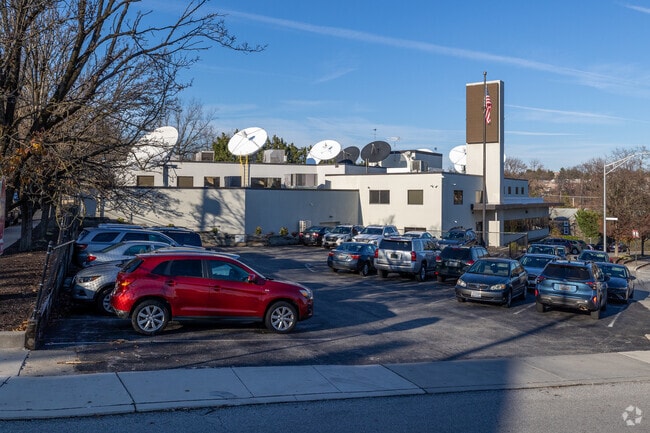
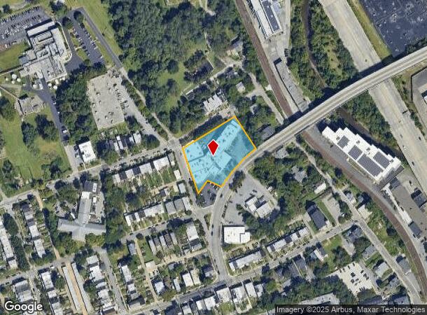
2000 W 41St St
3398-041
1.266 ACRES
Officebuilding
Baltimore City
X
Maryland
2400100385G
41
2024
1.27 AC
2025
Baltimore Northwest
130806
Baltimore
48,488 SF
Baltimore-Columbia-Towson, MD
DEMOGRAPHICS near 2000 W 41St St
1 mile
3 mile
5 mile
2024 Total Population
19,139
224,652
553,620
2029 Population
18,454
218,287
538,160
Pop Growth 2024-2029
(3.58%)
(2.83%)
(2.79%)
Average Age
42
40
40
2024 Total Households
9,063
97,641
236,662
HH Growth 2024-2029
(3.91%)
(3.13%)
(3.08%)
Median Household Inc
$60,621
$51,851
$56,707
Avg Household Size
2.00
2.10
2.20
2024 Avg HH Vehicles
1.00
1.00
1.00
Median Home Value
$244,326
$203,842
$219,682
Median Year Built
1949
1948
1950
Nearby Places
Map Layers
Map Styles
 Street
 Aerial
Transit
 Traffic
 Biking
Places
Listings with unknown addresses are not visible on the map
- Restaurants
- Banks
- Shops
- Fitness
- Groceries
PUBLIC TRANSPORTATION
TRANSIT/SUBWAY
Woodberry (Hunt Valley & BWI Marshall - Maryland Transit Administration Light Rail (Baltimore Light Rail), Timonium & Cromwell - Maryland Transit Administration Light Rail (Baltimore Light Rail))
Drive
Walk
Distance
Woodberry (Hunt Valley & BWI Marshall - Maryland Transit Administration Light Rail (Baltimore Light Rail), Timonium & Cromwell - Maryland Transit Administration Light Rail (Baltimore Light Rail))
2 min
7 min
0.4 mi
COMMUTER RAIL
Penn Station (Penn Line - Maryland Area Regional Commuter Trains (The MARC))
Drive
Walk
Distance
Penn Station (Penn Line - Maryland Area Regional Commuter Trains (The MARC))
9 min
3.5 mi
West Baltimore (Penn Line - Maryland Area Regional Commuter Trains (The MARC))
Drive
Walk
Distance
West Baltimore (Penn Line - Maryland Area Regional Commuter Trains (The MARC))
10 min
3.6 mi
AIRPORT
Baltimore/Washington International Thurgood Marshall
Drive
Walk
Distance
Baltimore/Washington International Thurgood Marshall
28 min
13.4 mi
Ronald Reagan Washington Ntl
Drive
Walk
Distance
Ronald Reagan Washington Ntl
74 min
45.7 mi
Freight Ports
Port of Baltimore
Drive
Walk
Distance
Port of Baltimore
12 min
5.1 mi
Nearby Properties
Address
Land Use
TOTAL SIZE
Lot Size
Zoning
Address
Land Use
TOTAL SIZE
Lot Size
Zoning
1,632,000 SF
106.32 AC
EC-2
Address
Land Use
TOTAL SIZE
Lot Size
Zoning
810,716 SF
28.88 AC
H
Address
Land Use
TOTAL SIZE
Lot Size
Zoning
1,228,117 SF
9.43 AC
C-2
Address
Land Use
TOTAL SIZE
Lot Size
Zoning
256,816 SF
1.27 AC
EC-2
Address
Land Use
TOTAL SIZE
Lot Size
Zoning
599,187 SF
30.14 AC
EC-2
Address
Land Use
TOTAL SIZE
Lot Size
Zoning
334,715 SF
1.77 AC
H
Address
Land Use
TOTAL SIZE
Lot Size
Zoning
189,700 SF
0.71 AC
TOD-4
Address
Land Use
TOTAL SIZE
Lot Size
Zoning
743.89 AC
OS
Address
Land Use
TOTAL SIZE
Lot Size
Zoning
372,287 SF
0.98 AC
R-10
Address
Land Use
TOTAL SIZE
Lot Size
Zoning
567,521 SF
8.12 AC
R-9
Address
Land Use
TOTAL SIZE
Lot Size
Zoning
5.03 AC
R-10
Address
Land Use
TOTAL SIZE
Lot Size
Zoning
320,000 SF
4.56 AC
TOD-4
Address
Land Use
TOTAL SIZE
Lot Size
Zoning
543,281 SF
7.28 AC
C-2
Address
Land Use
TOTAL SIZE
Lot Size
Zoning
366,234 SF
1.12 AC
R-10
Address
Land Use
TOTAL SIZE
Lot Size
Zoning
117,000 SF
71.11 AC
EC-2
Address
Land Use
TOTAL SIZE
Lot Size
Zoning
430,271 SF
56.35 AC
EC-2
Address
Land Use
TOTAL SIZE
Lot Size
Zoning
507,813 SF
4.94 AC
TOD-2
Address
Land Use
TOTAL SIZE
Lot Size
Zoning
457,289 SF
29.52 AC
TOD-2
Address
Land Use
TOTAL SIZE
Lot Size
Zoning
211,229 SF
7.46 AC
R-9
Address
Land Use
TOTAL SIZE
Lot Size
Zoning
158,600 SF
1.50 AC
TOD-4
Address
Land Use
TOTAL SIZE
Lot Size
Zoning
367,920 SF
2.87 AC
R-9
Address
Land Use
TOTAL SIZE
Lot Size
Zoning
54.25 AC
EC-1
Address
Land Use
TOTAL SIZE
Lot Size
Zoning
507 SF
3.58 AC
R-10
Address
Land Use
TOTAL SIZE
Lot Size
Zoning
245,951 SF
58.90 AC
EC-1
Address
Land Use
TOTAL SIZE
Lot Size
Zoning
1.15 AC
R-10
Address
Land Use
TOTAL SIZE
Lot Size
Zoning
218,005 SF
5.73 AC
R-10
Address
Land Use
TOTAL SIZE
Lot Size
Zoning
814,033 SF
23.60 AC
OR-2
Address
Land Use
TOTAL SIZE
Lot Size
Zoning
117,680 SF
23.12 AC
H
Address
Land Use
TOTAL SIZE
Lot Size
Zoning
334,557 SF
52 AC
R-6
Address
Land Use
TOTAL SIZE
Lot Size
Zoning
276,666 SF
3.05 AC
TOD-2
The World's #1 Commercial Real Estate Marketplace
Connect with us
© 2026 CoStar Group
The information above has been obtained from sources believed reliable. While we do not doubt its accuracy we have not verified it and make no guarantee, warranty or representation about it. It is your responsibility to independently confirm its accuracy and completeness. Any projections, opinions, assumptions, or estimates used are for example only and do not represent the current or future performance of the property. The value of this transaction to you depends on tax and other factors which should be evaluated by your tax, financial, and legal advisors. You and your advisors should conduct a careful, independent investigation of the property to determine to your satisfaction the suitability of the property for your needs.