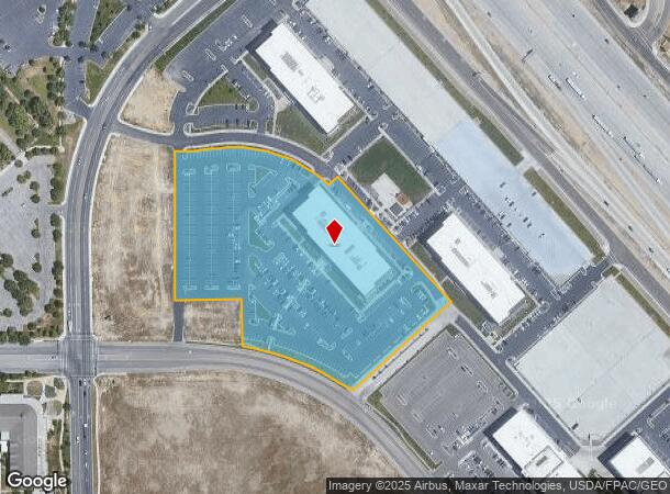
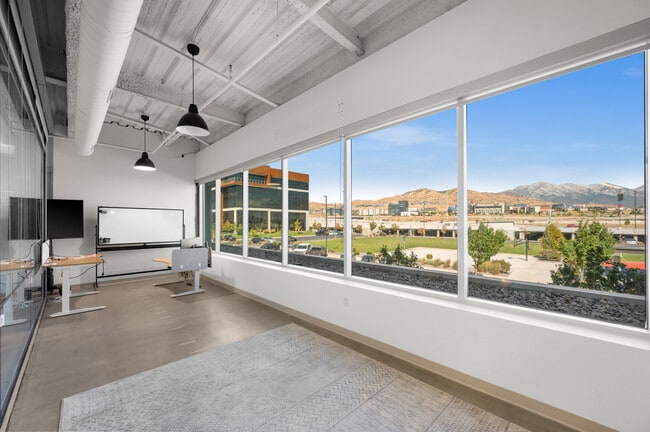
Property Record
2000 W Ashton Blvd, Lehi, UT 84048

NEARBY LISTINGS FOR SALE OR LEASE
Property Detail
2000 W Ashton Blvd
Provo-Orem, UT
COM N 0 DEG 1 25 W 432.86 FT & E 907.37 FT FR SW COR. SEC. 31, T4S, R1E, SLB&M.; ALONG A CURVE TO L (CHORD BEARS: N 86 DEG 47 1 E 95.93 FT, RADIUS = 425 FT); ALONG A CURVE TO R (CHORD BEARS: S 73 DEG 9 15 E 335.14 FT, RADIUS = 375 FT); N 48 DEG 17 35
11-032-0479
Utah
Officebuilding
Utah
2024
7.07 AC
2025
Utah County
010128
Salt Lake City
154,416 SF
DEMOGRAPHICS near 2000 W Ashton Blvd
1 Mile
3 Mile
5 Mile
2024 Total Population
8,882
83,535
163,377
2029 Population
10,491
99,115
189,840
Pop Growth 2024-2029
+ 18.12%
+ 18.65%
+ 16.20%
Average Age
30
29
30
2024 Total Households
2,418
22,986
44,662
HH Growth 2024-2029
+ 17.62%
+ 19.10%
+ 16.34%
Median Household Inc
$111,500
$117,642
$118,144
Avg Household Size
3.70
3.60
3.60
2024 Avg HH Vehicles
2.00
2.00
2.00
Median Home Value
$441,876
$507,129
$553,906
Median Year Built
2008
2010
2009
Nearby Places
Map Layers
Map Styles
 Street
 Aerial
- Restaurants
- Banks
- Shops
- Fitness
- Groceries
PUBLIC TRANSPORTATION
COMMUTER RAIL
Lehi Station (FrontRunner - Utah Transit Authority (UTA))
DRIVE
WALK
Distance
Lehi Station (FrontRunner - Utah Transit Authority (UTA))
6 min
20 min
1.1 mi
American Fork Station (FrontRunner - Utah Transit Authority (UTA))
DRIVE
WALK
Distance
American Fork Station (FrontRunner - Utah Transit Authority (UTA))
12 min
5.6 mi
AIRPORT
Provo Municipal
DRIVE
WALK
Distance
Provo Municipal
30 min
20.9 mi
Salt Lake City International
DRIVE
WALK
Distance
Salt Lake City International
36 min
30.2 mi
Freight Ports
Port of Stockton
DRIVE
WALK
Distance
Port of Stockton
737 min
720.6 mi
SALE & LEASE HISTORY
LISTING DATE
SALE/LEASE

Sep 25, 2024
For Lease
Oct 10, 2023
For Lease
Nov 25, 2024
For Lease
Mar 28, 2023
For Lease
Mar 17, 2023
For Lease
Mar 15, 2023
For Lease
Jun 07, 2024
For Lease
Feb 16, 2023
For Lease
Dec 08, 2022
For Lease
Aug 23, 2023
For Lease
Nearby Properties
Address
Land Use
TOTAL SIZE
Lot Size
Zoning
Address
Land Use
TOTAL SIZE
Lot Size
Zoning
2,586,860 SF
99.85 AC
Address
Land Use
TOTAL SIZE
Lot Size
Zoning
702,133 SF
19.46 AC
Address
Land Use
TOTAL SIZE
Lot Size
Zoning
264,805 SF
16.20 AC
Address
Land Use
TOTAL SIZE
Lot Size
Zoning
130,480 SF
27.19 AC
Address
Land Use
TOTAL SIZE
Lot Size
Zoning
36.17 AC
Address
Land Use
TOTAL SIZE
Lot Size
Zoning
313,847 SF
35.44 AC
Address
Land Use
TOTAL SIZE
Lot Size
Zoning
130,480 SF
25.12 AC
Address
Land Use
TOTAL SIZE
Lot Size
Zoning
376,499 SF
5.22 AC
Address
Land Use
TOTAL SIZE
Lot Size
Zoning
330,039 SF
10.08 AC
Address
Land Use
TOTAL SIZE
Lot Size
Zoning
386,065 SF
26.62 AC
Address
Land Use
TOTAL SIZE
Lot Size
Zoning
301,411 SF
13.27 AC
Address
Land Use
TOTAL SIZE
Lot Size
Zoning
166,233 SF
8.70 AC
Address
Land Use
TOTAL SIZE
Lot Size
Zoning
118,569 SF
23.63 AC
Address
Land Use
TOTAL SIZE
Lot Size
Zoning
374,937 SF
18.37 AC
Address
Land Use
TOTAL SIZE
Lot Size
Zoning
545,572 SF
182.84 AC
Address
Land Use
TOTAL SIZE
Lot Size
Zoning
281,215 SF
15.30 AC
Address
Land Use
TOTAL SIZE
Lot Size
Zoning
186,256 SF
4.19 AC
Address
Land Use
TOTAL SIZE
Lot Size
Zoning
131,961 SF
7.57 AC
Address
Land Use
TOTAL SIZE
Lot Size
Zoning
247,594 SF
19.01 AC
Address
Land Use
TOTAL SIZE
Lot Size
Zoning
194,033 SF
7.76 AC
Address
Land Use
TOTAL SIZE
Lot Size
Zoning
214,607 SF
7.31 AC
Address
Land Use
TOTAL SIZE
Lot Size
Zoning
194,767 SF
7.35 AC
Address
Land Use
TOTAL SIZE
Lot Size
Zoning
216,478 SF
7.38 AC
Address
Land Use
TOTAL SIZE
Lot Size
Zoning
255,672 SF
6.21 AC
Address
Land Use
TOTAL SIZE
Lot Size
Zoning
206,456 SF
6.55 AC
Address
Land Use
TOTAL SIZE
Lot Size
Zoning
215,516 SF
4.93 AC
Address
Land Use
TOTAL SIZE
Lot Size
Zoning
153,475 SF
3.37 AC
Address
Land Use
TOTAL SIZE
Lot Size
Zoning
181,908 SF
1.43 AC
Address
Land Use
TOTAL SIZE
Lot Size
Zoning
147,368 SF
6.91 AC
Address
Land Use
TOTAL SIZE
Lot Size
Zoning
304,991 SF
7.05 AC
The World's #1 Commercial Real Estate Marketplace
Connect with us
© 2026 CoStar Group
The information above has been obtained from sources believed reliable. While we do not doubt its accuracy we have not verified it and make no guarantee, warranty or representation about it. It is your responsibility to independently confirm its accuracy and completeness. Any projections, opinions, assumptions, or estimates used are for example only and do not represent the current or future performance of the property. The value of this transaction to you depends on tax and other factors which should be evaluated by your tax, financial, and legal advisors. You and your advisors should conduct a careful, independent investigation of the property to determine to your satisfaction the suitability of the property for your needs.