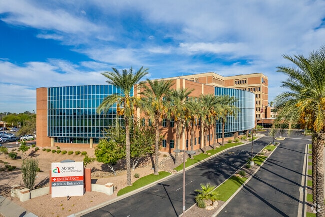
Property Record
2000 W Bethany Home Rd, Phoenix, AZ 85015

Property Detail
2000 W Bethany Home Rd
156-13-113D
PHOENIX BAPTIST HOSPITAL AND MEDICAL CENTER NO 2 MCR 451-47
Hospitalpublic
Maricopa
C-C
Arizona
C and X Area of minimal flood hazard, usually depicted on FIRMs as above the 500-year flood level.
1
2025
13.68 AC
2025
Northwest Phoenix
106802
Phoenix
474,952 SF
Phoenix-Mesa-Chandler, AZ
NEARBY LISTINGS FOR SALE OR LEASE
DEMOGRAPHICS near 2000 W Bethany Home Rd
1 mile
3 mile
5 mile
2025 Total Population
26,658
212,394
489,684
2030 Population
27,739
219,767
507,806
Pop Growth 2025-2030
+ 4.06%
+ 3.47%
+ 3.70%
Average Age
36
36
37
2025 Total Households
10,233
79,357
188,260
HH Growth 2025-2030
+ 4.08%
+ 3.77%
+ 4.05%
Median Household Inc
$51,973
$63,420
$65,178
Avg Household Size
2.50
2.50
2.50
2025 Avg HH Vehicles
1.00
2.00
2.00
Median Home Value
$357,393
$418,206
$399,148
Median Year Built
1971
1970
1973
Nearby Places
Map Layers
Map Styles
 Street
 Aerial
Layers
 Traffic
 Biking
Places
Listings with unknown addresses are not visible on the map
- Restaurants
- Banks
- Shops
- Fitness
- Groceries
PUBLIC TRANSPORTATION
TRANSIT/SUBWAY
Montebello/19Th Ave (METRO Light Rail - Valley Metro (Phoenix Light Rail))
Drive
Walk
Distance
Montebello/19Th Ave (METRO Light Rail - Valley Metro (Phoenix Light Rail))
1 min
7 min
0.4 mi
Glendale/19Th Ave (Valley Metro Rail - Valley Metro (Phoenix Light Rail))
Drive
Walk
Distance
Glendale/19Th Ave (Valley Metro Rail - Valley Metro (Phoenix Light Rail))
3 min
18 min
1.0 mi
AIRPORT
Phoenix Sky Harbor International
Drive
Walk
Distance
Phoenix Sky Harbor International
21 min
13.2 mi
Phoenix-Mesa Gateway
Drive
Walk
Distance
Phoenix-Mesa Gateway
53 min
40.0 mi
Freight Ports
Port of San Diego
Drive
Walk
Distance
Port of San Diego
399 min
357.5 mi
Nearby Properties
Address
Land Use
TOTAL SIZE
Lot Size
Zoning
Address
Land Use
TOTAL SIZE
Lot Size
Zoning
96,183 SF
11.04 AC
R-6
Address
Land Use
TOTAL SIZE
Lot Size
Zoning
913,637 SF
35.53 AC
M-H
Address
Land Use
TOTAL SIZE
Lot Size
Zoning
21,587 SF
3.66 AC
R-10
Address
Land Use
TOTAL SIZE
Lot Size
Zoning
956,022 SF
14.86 AC
Address
Land Use
TOTAL SIZE
Lot Size
Zoning
547,141 SF
18.52 AC
R-6
Address
Land Use
TOTAL SIZE
Lot Size
Zoning
496,222 SF
29.53 AC
C-R
Address
Land Use
TOTAL SIZE
Lot Size
Zoning
32,600 SF
2.38 AC
R-5
Address
Land Use
TOTAL SIZE
Lot Size
Zoning
337,487 SF
39 AC
R-6
Address
Land Use
TOTAL SIZE
Lot Size
Zoning
423,681 SF
8.29 AC
Address
Land Use
TOTAL SIZE
Lot Size
Zoning
5.67 AC
Address
Land Use
TOTAL SIZE
Lot Size
Zoning
464,812 SF
35.43 AC
R16
Address
Land Use
TOTAL SIZE
Lot Size
Zoning
299,513 SF
43.10 AC
M-H
Address
Land Use
TOTAL SIZE
Lot Size
Zoning
401,203 SF
7.25 AC
C2
Address
Land Use
TOTAL SIZE
Lot Size
Zoning
146,867 SF
12.95 AC
CPGCP
Address
Land Use
TOTAL SIZE
Lot Size
Zoning
1.82 AC
Address
Land Use
TOTAL SIZE
Lot Size
Zoning
211,015 SF
9.59 AC
R-6
Address
Land Use
TOTAL SIZE
Lot Size
Zoning
364,236 SF
2.99 AC
WU
Address
Land Use
TOTAL SIZE
Lot Size
Zoning
369,277 SF
3.31 AC
PAD
Address
Land Use
TOTAL SIZE
Lot Size
Zoning
194,523 SF
37.27 AC
R-6
Address
Land Use
TOTAL SIZE
Lot Size
Zoning
394,793 SF
3.60 AC
PUD
Address
Land Use
TOTAL SIZE
Lot Size
Zoning
540,839 SF
8.28 AC
M-H
Address
Land Use
TOTAL SIZE
Lot Size
Zoning
348,766 SF
37.16 AC
R-10
Address
Land Use
TOTAL SIZE
Lot Size
Zoning
342,995 SF
2.65 AC
WU
Address
Land Use
TOTAL SIZE
Lot Size
Zoning
281,990 SF
15.58 AC
R1-6
Address
Land Use
TOTAL SIZE
Lot Size
Zoning
364,351 SF
1.98 AC
C-C
Address
Land Use
TOTAL SIZE
Lot Size
Zoning
204,144 SF
17.64 AC
R-6
Address
Land Use
TOTAL SIZE
Lot Size
Zoning
439,655 SF
1.48 AC
C2
Address
Land Use
TOTAL SIZE
Lot Size
Zoning
250,180 SF
16.16 AC
C-C
Address
Land Use
TOTAL SIZE
Lot Size
Zoning
800,804 SF
0.50 AC
C-G
The World's #1 Commercial Real Estate Marketplace
Connect with us
© 2026 CoStar Group
The information above has been obtained from sources believed reliable. While we do not doubt its accuracy we have not verified it and make no guarantee, warranty or representation about it. It is your responsibility to independently confirm its accuracy and completeness. Any projections, opinions, assumptions, or estimates used are for example only and do not represent the current or future performance of the property. The value of this transaction to you depends on tax and other factors which should be evaluated by your tax, financial, and legal advisors. You and your advisors should conduct a careful, independent investigation of the property to determine to your satisfaction the suitability of the property for your needs.